Related Research Articles

The Arapaho are a Native American people historically living on the plains of Colorado and Wyoming. They were close allies of the Cheyenne tribe and loosely aligned with the Lakota and Dakota.

The Cheyenne are an Indigenous people of the Great Plains. The Cheyenne comprise two Native American tribes, the Só'taeo'o or Só'taétaneo'o and the Tsétsėhéstȧhese ; the tribes merged in the early 19th century. Today, the Cheyenne people are split into two federally recognized nations: the Southern Cheyenne, who are enrolled in the Cheyenne and Arapaho Tribes in Oklahoma, and the Northern Cheyenne, who are enrolled in the Northern Cheyenne Tribe of the Northern Cheyenne Indian Reservation in Montana. The Cheyenne language belongs to the Algonquian language family.

Roger Mills County is a county located in the western part of the U.S. state of Oklahoma. As of the 2020 census, the population was 3,442, making it the fourth-least populous county in Oklahoma. Its county seat is Cheyenne. The county was created in 1891.

Cheyenne is a town in Roger Mills County, Oklahoma, United States. As of the 2020 census, the town's population was 771. It is the county seat of Roger Mills County.

Strong City is a town in Roger Mills County, Oklahoma, United States. As of the 2020 census, the town’s population was 33.

The Sand Creek massacre was a massacre of Cheyenne and Arapaho people by the U.S. Army in the American Indian Wars that occurred on November 29, 1864, when a 675-man force of the Third Colorado Cavalry under the command of U.S. Volunteers Colonel John Chivington attacked and destroyed a village of Cheyenne and Arapaho people in southeastern Colorado Territory, killing and mutilating an estimated 70 to over 600 Native American people. Chivington claimed 500 to 600 warriors were killed. However, most sources estimate around 150 people were killed, about two-thirds of whom were women and children. The location has been designated the Sand Creek Massacre National Historic Site and is administered by the National Park Service. The massacre is considered part of a series of events known as the Colorado Wars.

Black Kettle was a leader of the Southern Cheyenne during the American Indian Wars. Born to the Northern Só'taeo'o / Só'taétaneo'o band of the Northern Cheyenne in the Black Hills of present-day South Dakota, he later married into the Wotápio / Wutapai band of the Southern Cheyenne.

The Battle of the Washita River occurred on November 27, 1868, when Lt. Col. George Armstrong Custer's 7th U.S. Cavalry attacked Black Kettle's Southern Cheyenne camp on the Washita River.

The Colorado War was an Indian War fought in 1864 and 1865 between the Southern Cheyenne, Arapaho, and allied Brulé and Oglala Sioux peoples versus the U.S. Army, Colorado militia, and white settlers in Colorado Territory and adjacent regions. The Kiowa and the Comanche played a minor role in actions that occurred in the southern part of the Territory along the Arkansas River. The Cheyenne, Arapaho, and Sioux played the major role in actions that occurred north of the Arkansas River and along the South Platte River, the Great Platte River Road, and the eastern portion of the Overland Trail. The United States government and Colorado Territory authorities participated through the 1st Colorado Cavalry Regiment, often called the Colorado volunteers. The war was centered on the Colorado Eastern Plains, extending eastward into Kansas and Nebraska.

The Cibola National Forest is a 1,633,783 acre United States National Forest in New Mexico, US. The name Cibola is thought to be the original Zuni Indian name for their pueblos or tribal lands. The name was later interpreted by the Spanish to mean "buffalo". The forest is disjointed with lands spread across central and northern New Mexico, west Texas and Oklahoma. The Cibola National Forest is divided into four Ranger Districts: the Sandia, Mountainair, Mt. Taylor, and Magdalena. The Forest includes the San Mateo, Magdalena, Datil, Bear, Gallina, Manzano, Sandia, Mt. Taylor, and Zuni Mountains of west-central New Mexico. The Forest also manages four National Grasslands that stretch from northeastern New Mexico eastward into the Texas Panhandle and western Oklahoma. The Cibola National Forest and Grassland is administered by Region 3 of the United States Forest Service from offices in Albuquerque, New Mexico. Elevation ranges from 5,000 ft to 11,301 ft. The descending order of Cibola National Forest acres by county are: Socorro, Cibola, McKinley, Catron, Torrance, Bernalillo, Sandoval County, New Mexico, Lincoln, Sierra, and Valencia counties in New Mexico. The Cibola National Forest currently has 137,701 acres designated as Wilderness. In addition to these acres, it has 246,000 acres classified as Inventoried Roadless Areas pursuant to the Roadless Area Conservation Rule.
Kiowa National Grassland is a National Grassland, located in northeastern New Mexico. The southwestern Great Plains grassland includes prairie and part of the Canadian River Canyon.
McClellan Creek National Grassland is a National Grassland located in southern Gray County, Texas, United States. It was purchased with the goal of restoring badly eroded land to its natural state. The grassland is administered by the U.S. Forest Service together with Cibola National Forest and Black Kettle, Kiowa, and Rita Blanca National Grasslands, from common headquarters located in Albuquerque, New Mexico. The grassland is part of the combined Black Kettle and McClellan Creek Ranger District with offices in Cheyenne, Oklahoma.
Rita Blanca National Grassland is a National Grassland on the Great Plains near the community of Texline in northwest Dallam County, Texas, in the Texas Panhandle, and in southern Cimarron County, Oklahoma, in the western Oklahoma Panhandle. The principal city in the area is Dalhart, Texas, which houses the XIT Museum.

State Highway 47 is a state highway in Oklahoma. It runs 94.6 miles (152.2 km) west-to-east in Roger Mills, Dewey and Custer counties.
The Cheyenne and Arapaho Tribes are a united, federally recognized tribe of Southern Arapaho and Southern Cheyenne people in western Oklahoma.

Howling Wolf was a Southern Cheyenne warrior who was a member of Black Kettle's band and was present at the Sand Creek Massacre in Colorado. After being imprisoned in the Fort Marion in Saint Augustine, Florida in 1875, Howling Wolf became a proficient artist in a style known as Ledger art for the accounting ledger books in which the drawings were done.

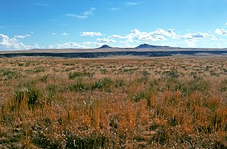
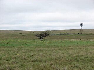
The Black Kettle National Grassland, in Roger Mills County, Oklahoma, and Hemphill County, Texas, contains 31,286 acres (12,661 ha) of which 30,710 acres (12,430 ha) are in Oklahoma.
Skipout Lake is located in Roger Mills County about 2 miles south and 3 miles east of Reydon in the State of Oklahoma. It is inside the Black Kettle National Grassland, which is managed by the Cibola National Forest. It is 60 acres in size. The lake is open year round, and has picnic areas, outdoor grills, and boat ramps/docks. Camping and RV facilities are also available.
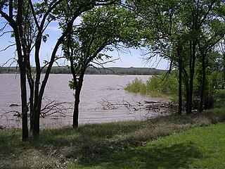
Spring Creek Lake is located on Spring Creek in Roger Mills County about 14 miles north of Cheyenne on US Route 283 and 8 miles west on SH-33, in the State of Oklahoma. It is inside the Black Kettle National Grassland, which is managed by the Cibola National Forest. It is 60 acres in size.
Spring Creek originates in Eastern Oklahoma near the town of Kansas, and flows generally southwest about 34 miles through Delaware, Cherokee, and Mayes counties before emptying into Fort Gibson Lake on the Grand (Neosho) River. Throughout its roughly 117,000 acre watershed, the creek is fed by small springs which contribute most of the estimated 15 million gallons of water that flow through it per day. Spring Creek is listed as having high quality water, being one of only five bodies of water in the state having this rating.
References
- ↑ "Dead Warrior Lake". Geographic Names Information System . United States Geological Survey, United States Department of the Interior . Retrieved August 11, 2021.
- 1 2 3 4 5 "Dead Warrior Lake christened". Josh Rabe, The Oklahoman, November 4, 2006. Retrieved July 22, 2021.
- 1 2 3 4 5 "Blackkettle National Grasslands". Cheyenne Roger Mills Chamber of Commerce. Archived from the original on May 15, 2014. Retrieved July 22, 2021.
{{cite web}}: CS1 maint: unfit URL (link) - ↑ "Roll, Oklahoma to Dead Warrior Lake". Google Maps. Retrieved December 20, 2021.
- ↑ "Dead Indian Lake". Google Maps. Retrieved July 22, 2021.
- ↑ "Grassland Information". US National Forest Campground Guide. Retrieved July 22, 2021.
- ↑ "Black Kettle and McClellan Creek National Grasslands". Forest Service. Retrieved July 22, 2021.
- ↑ "Cibola National Forest Homepage". US Forest Service. Retrieved July 22, 2021.
- ↑ "Fishing in Dead Warrior Lake". Fishbrain. Retrieved July 22, 2021.
- ↑ "Roll, Oklahoma". Google Maps. Retrieved December 20, 2021.
- ↑ "Dead Indian Creek, Oklahoma". Google Maps. Retrieved December 20, 2021.
- ↑ "Strong City, Oklahoma". Google Maps. Retrieved December 20, 2021.
35°44′53″N99°43′05″W / 35.748°N 99.718°W
| | This Oklahoma state location article is a stub. You can help Wikipedia by expanding it. |
| | This article related to a lake in the United States is a stub. You can help Wikipedia by expanding it. |