The Chalk Group is the lithostratigraphic unit which contains the Late Cretaceous limestone succession in southern and eastern England. The same or similar rock sequences occur across the wider northwest European chalk 'province'. It is characterised by thick deposits of chalk, a soft porous white limestone, deposited in a marine environment.
The geology of Hampshire in southern England broadly comprises a gently folded succession of sedimentary rocks dating from the Cretaceous and Palaeogene periods. The lower (early) Cretaceous rocks are sandstones and mudstones whilst those of the upper (late) Cretaceous are the various formations which comprise the Chalk Group and give rise to the county's downlands. Overlying these rocks are the less consolidated Palaeogene clays, sands, gravels and silts of the Lambeth, Thames and Bracklesham Groups which characterise the Hampshire Basin.
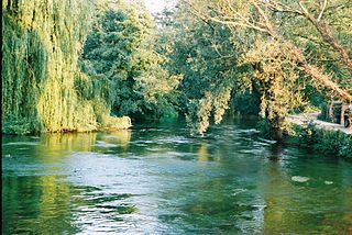
Twyford is a village and civil parish in Hampshire, England, approximately three miles south of Winchester and near the M3 motorway and Twyford Down. In 2001, the population of the parish was 1,456. The village and parish are on the left bank of the Itchen, which passes through nearby watermeadows, and has been important economically for its residents.
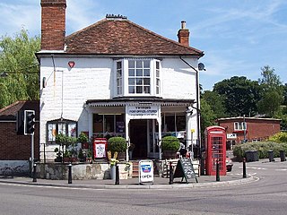
Fair Oak, Hampshire is a large village on the outskirts of Eastleigh, and near Southampton and Winchester. Its parish incorporates the neighbouring village of Horton Heath, which lies to the south.

Owslebury is a village and civil parish in the county of Hampshire, in the south of England approximately 5 miles (8.0 km) outside Winchester. It lies within the administrative district of the City of Winchester.

Compton and Shawford is a civil parish in the City of Winchester, Hampshire, England. The word compton means village in a combe and aptly describes the settlement as it primarily consists of a long street on the side of a chalk valley.
Beacon Hill, Warnford, Hampshire is a chalk hill in the South Downs on the boundary of the parishes of Warnford and Exton. Part of the hill is a national nature reserve and 44.8 hectares biological SSSI, first notified in 1979.

Chilcomb is a small village and civil parish in the English county of Hampshire 3 miles (4.8 km) east of Winchester and includes the South Downs Way long distance footpath.
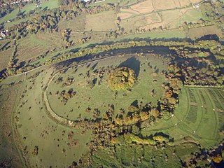
St. Catherine's Hill is a small but dramatic chalk hill to the south east of Winchester in Hampshire, England. Rising steeply some 67 metres (220 ft) from the water meadows of the River Itchen, the summit of the hill at 97 metres (318 ft) provides a fine view over Winchester.

The London Basin is an elongated, roughly triangular sedimentary basin approximately 250 kilometres (160 mi) long which underlies London and a large area of south east England, south eastern East Anglia and the adjacent North Sea. The basin formed as a result of compressional tectonics related to the Alpine orogeny during the Palaeogene period and was mainly active between 40 and 60 million years ago.

The Hampshire Basin is a geological basin of Palaeogene age in southern England, underlying parts of Hampshire, the Isle of Wight, Dorset, and Sussex. Like the London Basin to the northeast, it is filled with sands and clays of Paleocene and younger ages and it is surrounded by a broken rim of chalk hills of Cretaceous age.

The geology of East Sussex is defined by the Weald–Artois anticline, a 60 kilometres (37 mi) wide and 100 kilometres (62 mi) long fold within which caused the arching up of the chalk into a broad dome within the middle Miocene, which has subsequently been eroded to reveal a lower Cretaceous to Upper Jurassic stratigraphy. East Sussex is best known geologically for the identification of the first dinosaur by Gideon Mantell, near Cuckfield, to the famous hoax of the Piltdown man near Uckfield.
The Winchester-East Meon Anticline is one of a series of parallel east-west trending folds in the Cretaceous chalk of Hampshire. It lies at the western end of the South Downs, immediately to the north of the Hampshire Basin and south-east of Salisbury Plain.
The Winchester-King's Somborne Syncline is one of a series of parallel east-west trending folds in the Cretaceous chalk of Hampshire. It lies at the western end of the South Downs, immediately to the north of the Winchester-East Meon Anticline and east of Salisbury Plain.
The Stockbridge Anticline is one of a series of parallel east-west trending folds in the Cretaceous chalk of Hampshire. It lies at the western end of the South Downs, immediately to the north of the Winchester-King's Somborne Syncline and east of Salisbury Plain.
The Micheldever Syncline is one of a series of parallel east-west trending folds in the Cretaceous chalk of Hampshire. It lies at the western end of the South Downs, immediately to the north of the Stockbridge Anticline and east of Salisbury Plain.
The Alderbury-Mottisfont Syncline is an east-west trending fold in the Cretaceous chalk of Hampshire. It lies to the north of the Dean Hill Anticline and south of Salisbury Plain.
The geology of West Sussex in southeast England comprises a succession of sedimentary rocks of Cretaceous age overlain in the south by sediments of Palaeogene age. The sequence of strata from both periods consists of a variety of sandstones, mudstones, siltstones and limestones. These sediments were deposited within the Hampshire and Weald basins. Erosion subsequent to large scale but gentle folding associated with the Alpine Orogeny has resulted in the present outcrop pattern across the county, dominated by the north facing chalk scarp of the South Downs. The bedrock is overlain by a suite of Quaternary deposits of varied origin. Parts of both the bedrock and these superficial deposits have been worked for a variety of minerals for use in construction, industry and agriculture.
The Portsdown Anticline is a north-facing geological fold of Tertiary age affecting rocks in Hampshire, southern England. This upfold of the local sedimentary rock sequence is paralleled by the Bere Forest/Chichester Syncline (downfold) about 2km to its north and a postulated deep fault to the north again. Further west, this major east-west structure adopts more of a NW - SE alignment. At the surface the Portsdown Anticline is seen to affect the Chalk rocks of Late Cretaceous age at Ports Down though it is known to also affect the underlying Jurassic strata.
This article describes the geology of the New Forest, a national park in Hampshire, in southern England.