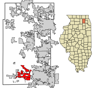
Sugar Grove is a village in Kane County, Illinois, United States. The population at the 2010 census was 8,997, and in 2018 the estimated population was 9,803.

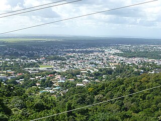
Pottsville is a city and the county seat of Schuylkill County, Pennsylvania, United States. The population was 13,346 at the 2020 census, and is the principal city of the Pottsville, PA Micropolitan Statistical Area. The city lies along the west bank of the Schuylkill River, 52 miles (84 km) south of Wilkes-Barre. It is located in Pennsylvania's Coal Region.

Lawrence Heights is a neighbourhood in Toronto, Ontario, Canada. It is located north-west of central Toronto, in the district of North York. The neighbourhood is roughly bounded by Lawrence Avenue to the south, Yorkdale Road to the north, Varna Drive to the east and Dufferin Street to the west. It is part of the greater Yorkdale-Glen Park official Toronto neighbourhood.
Penal is a town in south Trinidad, Trinidad and Tobago. It lies south of San Fernando, Princes Town, and Debe, and north of Moruga, Morne Diablo and Siparia. Penal is noted as a heartland of Hindu and Indo-Trinidadian culture.
Saint Augustine is a town in the northwest of Trinidad, Trinidad and Tobago.
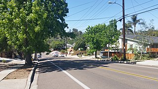
The College Area is a residential community in the Mid-City region of San Diego, California, United States. The College Area is dominated by San Diego State University, after which the area is named. Several neighborhoods in the College Area were developed in the 1930s, with others becoming established in the post-war period. The College Area is bordered on the west by Kensington and Talmadge and on the east by the city of La Mesa. El Cajon Boulevard is a busy shopping district; additional retail, entertainment and dining establishments are located in a new housing and commercial complex known as South Campus Plaza on College Avenue at Aztec Center. The College Area includes the neighborhoods of the Catoctin Area, Dennstedt Point, East Falls View Drive, Saranac-Mohawk, and an Orthodox Jewish neighborhood in the area near Congregation Beth Jacob Orthodox Synagogue on College Avenue. The region includes UC San Diego Health East Campus Medical Center, a 306-bed acute care facility, and the College-Rolando branch of the San Diego Public Library.

Salaga is a town and is the capital of East Gonja district, a district in the Savannah Region of north Ghana. Salaga had a 2012 settlement population of 25,472 people. Salaga was the largest slave market in the 18th and 19th centuries.
Saudabad is a neighborhood in Karachi, Pakistan, that is within Malir District. It was named after King Saud of Saudi Arabia.
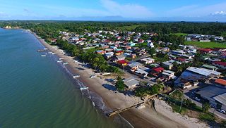
Cedros is a coastal area that lies on a peninsula at the South-Western end of the island of Trinidad. Named by Spanish sailors due to the once heavy presence of cedar trees, it is located at the tip of the peninsula which lies mere miles off the coast of Venezuela and is the most southern point in the Caribbean. The main area is known as Bonasse which is of French origin meaning "easy-going."

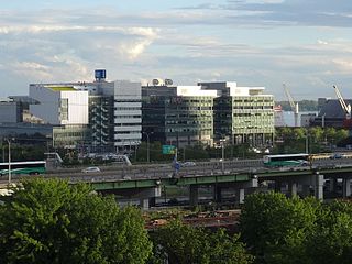
METRO Regional Transit Authority, also known as Akron Metropolitan Regional Transit Authority, is the public transit agency serving Summit County, Ohio and the city of Akron. It operates a number of local routes, and also operates one route into downtown Cleveland. Akron Metro transports passengers to/from school, work, grocery stores, malls and jobs all across Summit County. METRO RTA's fleet consists of about 200+ vehicles running on diesel, diesel-electric hybrid and as of 2022/2023, two fully electric Gillig vehicles, compressed natural gas fuels. In 2023, the system had a ridership of 4,260,900, or about 22,600 per weekday as of the first quarter of 2024.
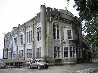
Mount Hermon School is a co-educational Christian boarding school in the town of Darjeeling, in the Indian state of West Bengal. It is located in North Point, Singmari. It follows the American education style, rather than the British style in vogue in the other schools of the area. It prepares children for ICSE and ISC. Mount Hermon offers classes in science, humanities, and commerce. More than 25 languages are spoken among the student body.

Dhupguri is a town and a municipality of Jalpaiguri district near Jaldhaka River in the state of West Bengal, India.It is the headquarters of the Dhupguri subdivision.

South Dum Dum is a city and a municipality of North 24 Parganas district in the Indian state of West Bengal. It is a part of the area covered by Kolkata Metropolitan Development Authority (KMDA) and a vital locality in Kolkata Metropolitan Area.
Warisaliganj is a Community Development block and a Municipal Council in Nawada district in the Indian state of Bihar.

Carapichaima is a town in central Trinidad, Trinidad and Tobago. Communities and villages in Carapichaima include Orangefield, Waterloo, Brickfield, and Korea Village.

Cross Green is a mainly industrial area of Leeds, West Yorkshire, England. It is around 1 mile (1.6 km) on a hill to the south east of Leeds city centre, with the A63 road running through the middle and dividing it into a residential estate with playing fields and housing to the north, and a large industrial estate to the south. The area lies in the LS9 Leeds postcode area between Osmondthorpe, Richmond Hill and Hunslet.
East Bayfront, or the East Bayfront Precinct, is an emerging neighbourhood in Toronto, Ontario, Canada. It is currently undergoing a transformation from industrial use to mixed-use as part of Waterfront Toronto's plans to create a residential and commercial district urban core near the lake.
Peachtree Hills is a neighborhood within the Buckhead district of Atlanta, Georgia. It primarily contains residential buildings, however, commercial buildings are scattered throughout the neighborhood. Peachtree Battle Shopping Center is located within the borders of Peachtree Hills.


