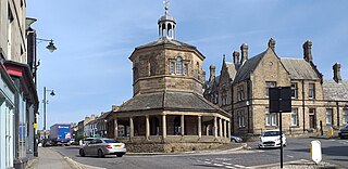
Barnard Castle is a market town on the north bank of the River Tees, in County Durham, England. The town is named after and built around a medieval castle ruin. The town's Bowes Museum has an 18th-century Silver Swan automaton exhibit and paintings by Goya and El Greco.

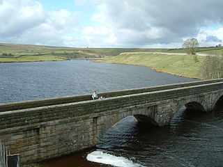
The River Tees, in England, rises on the eastern slope of Cross Fell in the North Pennines and flows eastwards for 85 miles (137 km) to reach the North Sea in the North East of England. The modern-day history of the river has been tied with the industries on Teesside in its lower reaches, where it has provided the means of import and export of goods to and from the North East England. The need for water further downstream also meant that reservoirs were built in the extreme upper reaches, such as Cow Green.
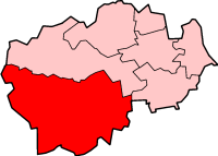
Teesdale was, from 1974 to 2009, a local government district in County Durham, England. Its council was based in Barnard Castle and it was named after the valley of the River Tees.
Startforth Rural District was a rural district in the North Riding of the historic county of Yorkshire in the Pennines of northern England.

Teesdale is a dale, or valley, located principally in County Durham, North East England. It is one of the Durham Dales, which are themselves part of the North Pennines, the northernmost part of the Pennine uplands.
Holwick is a small village in Teesdale, County Durham (district), England. Located in the Pennine hills, it consists of a few houses spread along a road in the pattern of a linear settlement. As the population taken at the 2011 Census was less than 100, details are maintained in the parish of Lunedale.
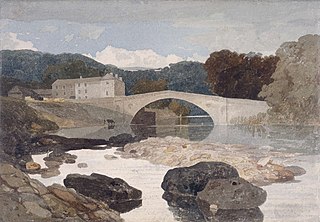
Greta Bridge is a hamlet on the River Greta in the parishes of Rokeby and Brignall in County Durham, England. The bridge is over the River Greta, just south of its confluence with the River Tees. The North Pennines, Teesdale and the Greta Bridge area – including the Meeting of the Waters – became a source of inspiration for romantic artists, poets and writers during the eighteenth century.

Mickleton is a village and civil parish in Teesdale, County Durham, England, situated 8.5 miles (13.7 km) north west of Barnard Castle. Lying within the historic boundaries of the North Riding of Yorkshire, the village along with the rest of the former Startforth Rural District has been administered with County Durham since 1 April 1974, under the provisions of the Local Government Act 1972

Merrybent is a linear village in the civil parish of Low Coniscliffe and Merrybent in County Durham, in England. It is situated on the A67 road to the west of Darlington, a short distance to the north of the River Tees and the Teesdale Way. At the beginning of the 20th century there were hardly any buildings here, and its main feature at that time was Merrybent Nurseries with its many glasshouses. The nursery was cut through by the A1 road in the 1960s; at this point it runs on the trackbed of the old Merrybent railway. The village is now a settlement of modern housing.

Winston is a village and civil parish in County Durham, England. It is situated approximately 6 miles (9.7 km) east of Barnard Castle, on a crossroads between the A67 and B6274 roads. According to the 2011 UK Census the population was 431, the parish includes the hamlets of Little Newsham and South Cleatlam.
The Walney to Wear and Whitby Cycle Route is the name of a cross-country cycle route in Northern England. It runs from Walney Island in Cumbria to Sunderland on the River Wear or Whitby.

The Teesdale Way is a long-distance walk between the Cumbrian Pennines and the North Sea coast of North Yorkshire in England. The walk is 100 miles (160 km) in length; it links in with other long-distance walks such as the Pennine Way and the E2 European Walk between Harwich and Stranraer.

Baldersdale is a dale, or valley, on the east side of the Pennines in England, northwest of Barnard Castle. Its principal settlements are Hury and Briscoe. Baldersdale lies within the traditional boundaries of the North Riding of Yorkshire. Under provisions of the Local Government Act 1972, it was incorporated into County Durham for administrative purposes on 1 April 1974, along with the rest of the former Startforth Rural District.

The Balder is an English river that rises on the eastern slope of Stainmore Common in the Pennine Chain and flows eastwards for about 23.4 kilometres (14.5 mi), before joining the River Tees at Cotherstone.
Lunedale is the dale, or valley, of the River Lune, on the east side of the Pennines in England, west of Middleton-in-Teesdale. Its principal settlements are Grassholme, Thringarth and Bowbank.

The South Durham and Lancashire Union Railway (SD&LUR) built a railway line linking the Stockton and Darlington Railway near Bishop Auckland with the Lancaster and Carlisle Railway at Tebay, via Barnard Castle, Stainmore Summit and Kirkby Stephen. The line opened in 1861 and became known as the Stainmore Line.

The Tees Valley Railway was an 8+3⁄4-mile (14.1 km) branch railway line that ran between Barnard Castle on the South Durham & Lancashire Union Railway line between Bishop Auckland and Kirkby Stephen East, and Middleton-in-Teesdale via three intermediate stations Cotherstone, Romaldkirk and Mickleton.
The Durham Dales are a series of valleys in the west of County Durham, North East England. They are the Durham portion of the North Pennines, the northernmost part of the Pennine uplands. The principal valleys are Teesdale in the south and Weardale in the north, each of which has several side valleys, including Baldersdale, Lunedale, and Rook Hope. The part of Teesdale south of the Tees was historically in Yorkshire.
