Deister Gate

Last updated
Deister Gate
Deisterpforte vom Katzberg.jpg
View from the Katzberg ridge of the Deister Gate. Left: the Ebersberg; right: the Raher Berg
Elevation 130DE-NN
Coordinates 52°11′59″N9°31′41″E / 52.1998500°N 9.5280000°E / 52.1998500; 9.5280000 Coordinates: 52°11′59″N9°31′41″E / 52.1998500°N 9.5280000°E / 52.1998500; 9.5280000
The Deister Gate between the Deister and Kleiner Deister Kleiner Deister.jpg
The Deister Gate between the Deister and Kleiner Deister
The B 217 near Sedemunder with a view of the Deister Gate B 217 Sedemunder Deisterpforte neu.jpg
The B 217 near Sedemünder with a view of the Deister Gate
View from the Ebersberg of the pass of the Deister Gate Deisterpforte von Springe.jpg
View from the Ebersberg of the pass of the Deister Gate

The Deister Gate (German : Deisterpforte) is a 550-metre-wide gap between the Deister and Kleiner Deister hill ridges in Springe in Hanover Region, Lower Saxony, Germany. The height of the pass varies between 130 m above NN to 120 m above NN. [1] The River Haller rises in the Deister Gate. Several transport and supply routes run through the Deister Gate.

German language West Germanic language

German is a West Germanic language that is mainly spoken in Central Europe. It is the most widely spoken and official or co-official language in Germany, Austria, Switzerland, South Tyrol (Italy), the German-speaking Community of Belgium, and Liechtenstein. It is also one of the three official languages of Luxembourg and a co-official language in the Opole Voivodeship in Poland. The languages which are most similar to German are the other members of the West Germanic language branch: Afrikaans, Dutch, English, the Frisian languages, Low German/Low Saxon, Luxembourgish, and Yiddish. There are also strong similarities in vocabulary with Danish, Norwegian and Swedish, although those belong to the North Germanic group. German is the second most widely spoken Germanic language, after English.

Deister mountain range

The Deister is a chain of hills in the German state of Lower Saxony, about 15 mi (25 km) southwest of the city of Hanover. It runs in a north-westerly direction from Springe in the south to Rodenberg in the north. The next in the chain of hills to the south is the Kleiner Deister from which it is separated by the flat pass of the Deister Gate. It is surrounded by Springe, Wennigsen, Barsinghausen, Bad Nenndorf, Rodenberg and Bad Münder.

Kleiner Deister mountains in Germany

The Kleiner Deister is a ridge of hills in the Calenberg Uplands which, together with the Nesselberg and the Osterwald, forms a group of three adjacent hill ranges in the northern part of the Leine Uplands. It lies between Springe and Eldagsen in Hanover region in Lower Saxony, Germany.

Contents

Etymology

Around the year 1,000, the site of the karst spring in the Deister Gate is mentioned in a description of the boundaries of the Bishopric of Hildesheim under the name Helereisprig. The Haller forms the boundary between the Bishoprics (now Dioceses) of Hildesheim to the south and Minden to the north. The location of the karst spring was called Hallerbrunn in 1631, [2] Haller Brunn in 1783, [3] Hallerbrunn in 1896, [4] and Hallerbrunnen in 1950. [5] The town of Springe derives its name from the source of the Haller; until the 18th century it was called Hallerspring. Hans-Heinrich Seedorf suspects, "that Haller means something like noisesome, swift stream." [6]

Karst spring spring that is part of a karst system

A karst spring is a spring that is part of a karst system. That includes the underground drainage of a much larger area, which means that karst springs often have a very large discharge. Because of their often conical or bowl shape, such water sources are also known in German-speaking lands as a Topf ("pot") which is reflected in names such as Aachtopf or Blautopf.

Bishopric of Hildesheim

The Prince-Bishopric of Hildesheim was a state of the Holy Roman Empire from the Middle Ages until 1803. It was the territory of princely rule held by the incumbents of the Roman Catholic Diocese of Hildesheim, therefore wielding secular and religious functions as prince-bishops. It was named after its capital, Hildesheim.

Haller (river) river in Germany

Haller is a river of Lower Saxony, Germany. It flows into the Leine near Nordstemmen.

Geography

The Deister Gate is bounded to the north by the Ebersberg (355 m above NN) and to the south by the Raher Berg (285 m above NN). The B 217 from Hanover to Hamelin, a Landstraße , two farm and forest tracks, the Hanover–Altenbeken railway, carrying S-Bahn line 5 from Paderborn via Hamelin and Hannover Central to Hanover Airport, and the upper reaches of the River Haller run through the pass. The E1 European long distance path runs along the forest track on the edge of the Deister and through the Deister Gate.

Ebersberg (Deister) mountain

The Ebersberg lies on the southern slopes of the Deister ridge in Germany.

Hanover Place in Lower Saxony, Germany

Hanover or Hannover is the capital and largest city of the German state of Lower Saxony. Its 535,061 (2017) inhabitants make it the thirteenth-largest city of Germany, as well as the third-largest city of Northern Germany after Hamburg and Bremen. The city lies at the confluence of the River Leine and its tributary Ihme, in the south of the North German Plain, and is the largest city of the Hannover–Braunschweig–Göttingen–Wolfsburg Metropolitan Region. It is the fifth-largest city in the Low German dialect area after Hamburg, Dortmund, Essen, and Bremen.

Hamelin Place in Lower Saxony, Germany

Hamelin is a town on the river Weser in Lower Saxony, Germany. It is the capital of the district of Hamelin-Pyrmont and has a population of roughly 56,000. Hamelin is best known for the tale of the Pied Piper of Hamelin.

South of the Deister Gate, in the valley of the Hamel lie the villages of Bad Münder und Altenhagen I, the state farm of Dahle and the abandoned village of Sedemünder. [7] There, in front of the Deister Gate, the Battle of Sedemünder took place on 28 July 1260. To the north is the Haller valley and the town of Springe in the Springe Bowl (Springer Kessel). In this direction, 600 metres from the pass, was once a sawmill powered by the Haller. Today a furniture factory stands on the site.

Hamel (river) river in Germany

Hamel is a river of Lower Saxony, Germany. It flows into the Weser in Hameln.

Abandoned village village that has been deserted

An abandoned village is a village that has, for some reason, been deserted. In many countries, and throughout history, thousands of villages have been deserted for a variety of causes. Abandonment of villages is often related to epidemic, famine, war, climate change, environmental destruction, or deliberate clearances.

The Battle of Sedemünder was a military conflict between the episcopal army of the Bishop of Minden, Wedekind, and an army of Hamelin's townsfolk. It took place on 28 July 1260 or, according to other sources, on 28 July 1259, near the abandoned village of Sedemünder, south of the Deister Gate in what is now Lower Saxony. The battle ended in a crushing defeat of the townsfolk, whose survivors were taken into captivity in Minden. The strengths and casualties of the two sides are unknown.

At the southern edge of the Deister Gate is an old quarry on the side of the Raher Berg. In the lower part of the quarry stands a club house, above it the quarry climbs like a romantic valley up the hillside. Nearby is a forest track through the woods which cuts through the Bückethaler Landwehr , which is described here on an information board. The forest track then continues to the town of Springe.

Landwehr (border) border demarcations or border defences and enclosures in Central Europe

The terms landwehr, landgraben and landhege refer to border demarcations or border defences and enclosures in Central Europe that were either built by settlements with the right of enclosure or to mark and defend entire territories. These measures, usually comprising earthworks or dykes as well as ditches and impenetrable lines of hedging, for protecting towns and villages date mainly to the High and Late Middle Ages and consist, in some cases, of systems over a hundred kilometres long. Comparable earthworks have been recorded since Antiquity. The Roman limes are the best known examples of earlier landwehrs. The Danewerk is another example of this type of barrier.

The forest inn, Deisterpforte, was built in 1876 by the Ratskeller publican, Christian Bauer, on the edge of Springe as a daytrippers' destination; it is still in operation.

Related Research Articles

Principality of Calenberg principality

The Principality of Calenberg was a dynastic division of the Welf duchy of Brunswick-Lüneburg established in 1432. Calenberg was ruled by the House of Hanover from 1635 onwards; the princes received the ninth electoral dignity of the Holy Roman Empire in 1692. Their territory became the nucleus of the Electorate of Hanover, ruled in personal union with the Kingdom of Great Britain from 1714 onwards. The principality received its name from Calenberg Castle, a residence of the Brunswick dukes.

Barsinghausen Place in Lower Saxony, Germany

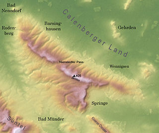
Barsinghausen is a town in the district of Hanover, in Lower Saxony, Germany. It is situated at the Deister chain of hills approx. 20 km west of Hanover. Barsinghausen belongs to the historic landscape Calenberg Land and was first mentioned in 1193.

Springe Place in Lower Saxony, Germany

Springe is a town in the district of Hanover, in Lower Saxony, Germany. It is situated near the Deister hills, 22 kilometres (14 mi) southwest of Hanover.

Wesergebirge mountain range

The Weser Hills (Wesergebirge), also known in German as the Weserkette, form a low hill chain, up to 326.1 m above sea level (NN), in the Weser Uplands in the German states of North Rhine-Westphalia and Lower Saxony.

Nesselberg mountains in Germany

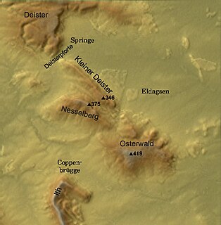
The Nesselberg is a ridge up to 378.2 m above sea level (NN) high in the Calenberg Highland which, together with the Kleiner Deister and the Osterwald, forms a group of three contiguous hill regions in the northwestern part of the Leine Uplands. It lies between Altenhagen I and Coppenbrügge in Lower Saxony, Germany.

Süntel mountain range

The Süntel  is a massif in the German Central Uplands that is up to 437.5 m above sea level (NN). It forms part of the Weser Uplands in Lower Saxony southwest of Hanover and north of Hamelin.

Thüster Berg mountain range

The Thüster Berg is a ridge, up to 441 m above NN, in the Lower Saxon Hills in central Germany. It is situated in the districts of Hameln-Pyrmont and Hildesheim in the federal state of Lower Saxony.

Weser Uplands-Schaumburg-Hamelin Nature Park nature park in Lower Saxony, Germany

The Weser Uplands-Schaumburg-Hamelin Nature Park lies on the northern edge of the German Central Uplands where it transitions to the North German Plain, about 50 kilometres (31 mi) southwest of Hanover. The sponsor of the nature park, which was founded in 1975, is the state of Lower Saxony. The park extends along the Weser valley between Rinteln and Hamelin and includes parts of the Schaumburg Land, Calenberg, Lippe and Pyrmont Uplands from Bad Nenndorf in the north to Bad Pyrmont in the south, Bückeburg and Bad Eilsen in the west and Bad Münder and Osterwald in the east. Its highest elevation is in the Süntel hills.

Calenberg Land geographic region

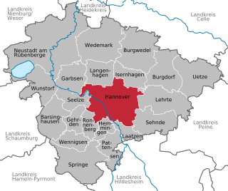
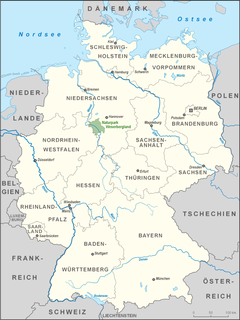
The Calenberg Land is a historic landscape southwest of Hanover in Germany, roughly formed by the countryside between the Leine and the Deister hills. The name of this region comes from the Principality of Calenberg ruled the area during the Middle Ages with its seat at Calenberg Castle near Pattensen.

Calenberg mountain

The Calenberg is a hill in central Germany in the Leine depression near Pattensen in the municipality of Schulenburg. It lies 13 km west of the city of Hildesheim in south Lower Saxony on the edge of the Central Uplands. It is made from a chalk marl slab (Kalkmergelbank), has a height of 70 m above NN and was formed almost 100 million years ago at the beginning of the Upper Cretaceous series in Cenomanian stage. The Calenberg became historically important as a result of the fort, stronghold and castle built as the main residence of the House of Hanover.

Deister-Süntel valley

The Deister-Süntel valley lies in the northeast Weser Uplands in the north German state of Lower Saxony between the ridges of the Bückeberg, Süntel and Deister in the districts of Schaumburg and Hameln-Pyrmont.

Nordstemmen station railway station in Nordstemmen, Germany

Nordstemmen station is located on the Hanover–Göttingen railway and the Hildesheim–Löhne railway in the town of Nordstemmen in the German state of Lower Saxony. The station building was built by Conrad Wilhelm Hase (1853–1854), but it has not been used by Deutsche Bundesbahn or Deutsche Bahn since 1977. Since 2011, the Hildesheim contractor Dirk Bettels has tried in vain to acquire and rehabilitate the grade II heritage-listed station building with public funds. Construction work begun by Dirk Bettels was discontinued at the end of March 2013 because no contract had been signed by Deutsche Bahn.

Wolfsberg (Calenberg Land)

The Wolfsberg is a spur of the Süllberg, 152.1 m above sea level (NN), in the Calenberg Land near Springe in the Hanover Region.

Aegidienkirche, Hanover Church in Hanover, Germany

The Aegidienkirche was a church in Hanover, the capital of Lower Saxony, Germany. It was one of three churches in the Old Town, the others being the Marktkirche and the Kreuzkirche. It was destroyed in World War II, and was left in ruins as a war memorial.

Karl Erich Andrée German paleontologist

Karl Erich Andrée was a German geologist and paleontologist.

The so-called Agrivarian Wall was mentioned by the Roman historian, Tacitus, in connexion with the campaign by the Roman general Germanicus in 16 A.D. which included the Battle of the Angrivarian Wall. It was here that the legions of Germanicus and the army of Arminius had their final conflict.

Mathisleweiher

The Mathisleweiher is a large bog lake, under 2 hectares in area, in the Black Forest in southern Germany. It lies in the High Black Forest between Feldberg in the west and the Titisee in the east on the territory of Hinterzarten at about 999 m above NN southwest of the village in the Eschengrundmoos Nature Reserve. The pond impounds the Zartenbach which flows through it from west-southwest to east-northeast. The stream rises on the eastern slopes of the Ramselehöhe at about 1,055 m above NN, picks up the Eschengrundmoosbach from the right from the protected bog and runs for less than a kilometre before entering the lake. A shorter stream runs from the north from the woods of the Stuckwald. It has a catchment of 1.0 km2

References

  1. The pass is not level and has sharp height differences between 130 m and 120 m above sea level (NN).
  2. Source: Flurnamenlexikon zur Flurnamenkarte Springe-West. Bearbeitet von Heinz Weber. Hanover, 1982. p. 20.
  3. Kurhannoversche Landesaufnahme des 18. Jahrhunderts
  4. Königlich Preußische Landesaufnahme
  5. Topographische Karten des Niedersächsischen Landesverwaltungsamtes Sheet 3723 (Springe) and 3823 (Eldagsen).
  6. Hans-Heinrich Seedorf: Hallerbrunnen. In: Förderverein für die Stadtgeschichte von Springe e. V.: Erlebnisweg vom Schulzentrum Süd zur Hallerquelle. Springe, 2013. pp. 36ff.
  7. Achim Gercke: Sedemünder – das ältere Münder im Sünteltal. Die Geschichte eines untergegangenen Dorfes. Festvortrag zum 40-jährigen Bestehen des Kreisvereins des Heimatbundes Niedersachsen, gehalten am 16. August 1975. Selbstverlag Achim Gercke, Adensen, 1975.

Literature