Deke Sokehs

Last updated
Sokehs Peninsula
Peninsula
Flag of Pohnpei.svg
Flag
Pohnpei-NW.jpg
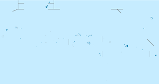
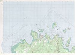
Deke Sokehs on the map of norwest Pohnpei
Coordinates: 6°58′N158°11′E / 6.967°N 158.183°E / 6.967; 158.183 Coordinates: 6°58′N158°11′E / 6.967°N 158.183°E / 6.967; 158.183
Country Flag of Federated States of Micronesia.svg Federated States of Micronesia
State Flag of Pohnpei.svg Pohnpei
District Sokehs
Largest Village Mwalok
Area
  Total 6.3 km2 (2.4 sq mi)
Dimensions
  Length 3.8 km (2.4 mi)
  Width 2.5 km (1.6 mi)
Population (2010)
  Total 200
  Density 32/km2 (82/sq mi)

Deke Sokehs, or Sokehs Peninsula, is a mountainous peninsula on the north coast of Pohnpei in the Federated States of Micronesia. [1] It was formerly an island, known as Sokehs Island, but it is now connected to the main island by causeway and a field of mangroves. The 1570-meter-long Dau Mwoakote Channel cuts through the mangroves, which, except in the west, is only a few meters wide.

Pohnpei island in Micronesia

Pohnpei "upon (pohn) a stone altar (pei)" is an island of the Senyavin Islands which are part of the larger Caroline Islands group. It belongs to Pohnpei State, one of the four states in the Federated States of Micronesia (FSM). Major population centers on Pohnpei include Palikir, the FSM's capital, and Kolonia, the capital of Pohnpei State. Pohnpei Island is the largest (334 km²), with a highest point, most populous, and most developed single island in the FSM.

Federated States of Micronesia Island republic in Oceania

The Federated States of Micronesia is an independent republic associated to the United States. It consists of four states – from west to east, Yap, Chuuk, Pohnpei and Kosrae – that are spread across the Western Pacific Ocean. Together, the states comprise around 607 islands that cover a longitudinal distance of almost 2,700 km (1,678 mi) just north of the equator. They lie northeast of New Guinea, south of Guam and the Marianas, west of Nauru and the Marshall Islands, east of Palau and the Philippines, about 2,900 km (1,802 mi) north of eastern Australia and some 4,000 km (2,485 mi) southwest of the main islands of Hawaii.

It belongs to Sokehs Municipality and lies to the west of Kolonia. [2] Settlements from south to north include Reou, Ahseia, Soledi, Kamwele, Mwalok, Roie, Naneir, Peilong, Kepindau, and Danipei. [1]

Sokehs village and municipality on the main island in the state of Pohnpei, Federated States of Micronesia

Sokehs is a village and municipality on the main island in the state of Pohnpei, Federated States of Micronesia.

Kolonia town in Micronesia

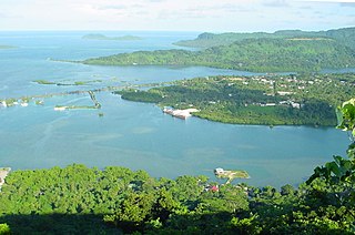
Kolonia is a coastal town and the capital of Pohnpei State in the Federated States of Micronesia (FSM). It was also the former FSM capital before being replaced by Palikir in 1989, located nearby to the southwest in the municipality of Sokehs. It has about 6,000 people.

Sokehs is the location of Sokehs Rock, a prominent cliff face that is one of Micronesia's best-known geographic features. It was also the site of Sokehs Rebellion, an uprising by islanders in October 1910 against colonial German rule. The uprising was suppressed in early 1911, leading to the execution of 15 rebels and the exiling of several hundred Sokehs islanders to Palau.

German Empire empire in Central Europe between 1871–1918

The German Empire, also known as Imperial Germany, was the German nation state that existed from the unification of Germany in 1871 until the abdication of Kaiser Wilhelm II in 1918.

Palau republic in Oceania

Palau, officially the Republic of Palau, is an island country located in the western Pacific Ocean. The country contains approximately 340 islands, forming the western chain of the Caroline Islands in Micronesia, and has an area of 466 square kilometers (180 sq mi). The most populous island is Koror. The capital Ngerulmud is located on the nearby island of Babeldaob, in Melekeok State. Palau shares maritime boundaries with the Philippines, Indonesia, and the Federated States of Micronesia.

Related Research Articles

Palikir Place in Pohnpei State, F.S. Micronesia

Palikir is a town with about 4,600 people and the capital of the Federated States of Micronesia in the western Pacific Ocean. It is part of the much larger Sokehs municipality, which had a population of 7,000 as of 2009, out of the nation's total population of 106,487. It is situated on the northwest side of Pohnpei island, a high volcanic island surrounded by a fringing coral reef. Nearby to the northeast is the island's largest settlement, the coastal town of Kolonia.

Babeldaob island

Babeldaob is the largest island in the island nation of the Republic of Palau. It is in the western Caroline Islands, and the second largest island in the Micronesia region of Oceania. Palau's capital, Ngerulmud, is located on Babeldaob, in Melekeok State.

Nukuoro island group

Nukuoro is an atoll in the Federated States of Micronesia.

Pohnpei State state in Federated States of Micronesia

Pohnpei State is one of the four states of the Federated States of Micronesia (FSM). The other states are, from the east to west, Kosrae State, Chuuk State, and Yap State. The state's principal island is Pohnpei.

Nett

Nett also written as Net, is one of the administrative divisions of Pohnpei State, Federated States of Micronesia.

Kitti (municipality)

Kitti also written as Kiti, is one of the twelve administrative divisions of the Micronesian state of Pohnpei. it is located in the southwest of Pohnpei island, to the south of Mount Nanlaud.

Madolenihmw municipality

Madolenihmw is one of the administrative divisions of the Micronesian island of Pohnpei. It is located in the central east of the island, to the east of Mount Nahna Laud and south of Mount Kapwuriso. The coast of Madolenihmw includes a large bay which contains the island of Temwen, famous for its Nan Madol ruins.

Sokehs rebellion

Sokehs rebellion was an uprising of the Sokehs tribe against local German rule that started on Sokehs Island off the main island of Pohnpei in the Eastern Caroline Islands in 1910/1911. The German district commissioner, Gustav Boeder, three other German officials and five islanders were killed by the rebels before German naval units arrived and restored order.

U, Pohnpei

U also written Uh, is one of the administrative divisions of Pohnpei State, Federated States of Micronesia. U bears the shortest place name in the Federated States of Micronesia, and one of the shortest in the world.

Oroluk

Oroluk is one of the administrative divisions of Pohnpei State, Federated States of Micronesia.

Sapwuahfik archipelago

Sapwuahfik, formerly Ngatik, or the Raven Islands is a 110-square-kilometre (42 sq mi) atoll of the Federated States of Micronesia. It is a village and municipality of roughly 430 people on a land area of 1.5 square kilometres (0.58 sq mi) in the state of Pohnpei.

Mokil

Mokil, or known to the locals as Mwoakilloa, is an atoll and one of 6 outer-island municipalities in the state of Pohnpei, Federated States of Micronesia. Almost 200 people live on a land area of about 1 square km.

Japanese Artillery Road and Pohndolap Area

The Japanese Artillery Road and Pohndolap Area are a historic area on Sokehs Island in the Federated States of Micronesia. Sokehs has a prominent north-south ridge (known locally as "Pohndolap", overlooking the state capital Kolonia, and was fortified by the Japanese during World War II. They built a road to the summit area and emplaced anti-aircraft guns on the ridge. The ridge was also a key site in the 1910 Sokehs Rebellion against Japanese rule, and the remnants of a Pohnpeian fort are also in the area. The surviving elements of these fortifications were listed on the United States National Register of Historic Places in 1976. The old road is now part of a hiking trail, leading up to the fortifications.

Sokehs Mass Grave Site

The Sokehs Mass Grave Site is the location where fifteen participants of the 1910/1911 Sokehs Rebellion on the island of Pohnpei were buried by German colonial authorities. The rebellion broke out in October 1910 on Sokehs Island and was suppressed by German naval forces by early 1911. At a summary trial of 36 Sokehs rebels, 17 were convicted of murder and insurrection, and 15 subsequently executed by firing squad and buried in this mass grave. All members of the Sokehs tribe were then exiled to Babelthuap. The mass grave site is a roughly square area 16 feet (4.9 m) on each side, surrounded by a low stone wall. The site is now identified by a memorial marker.

Pohnpei State Department of Education (PDOE) is an agency of Pohnpei State, Federated States of Micronesia that operates public schools.

Bailey Olter High School

Bailey Olter High School, formerly Pohnpei Island Central School (PICS), and Pacific Islands Central School, is a senior high school in Kolonia, Pohnpei Island, Pohnpei State, Federated States of Micronesia. As of 2018 the school, operated by the Pohnpei State Department of Education, has about 1,500 students, making it the state's largest high school. Its service area includes Kolonia, Nett, Sokehs, and U.

References

  1. 1 2 "Map of Ponape". United States Geological Survey. 1983. Retrieved 12 May 2013 via Wikimedia.
  2. Panholzer, Thomas; Rufino, Mauricio (2003). Place Names Of Pohnpei Island: Including And Ant And Pakin Atolls. Bess Press. p. 106. ISBN   978-1-57306-166-7 . Retrieved 12 May 2013.