Chester County, colloquially known as Chesco, is a county in the Commonwealth of Pennsylvania. It is located in the Delaware Valley region of the state. As of the 2020 census, the population was 534,413, increasing by 7.1% from 498,886 in 2010. The county seat and most populated municipality is West Chester. Chester County was one of the three original Pennsylvania counties created by William Penn in 1682. It was named for Chester, England.

Brandywine Creek is a tributary of the Christina River in southeastern Pennsylvania and northern Delaware in the United States. The Lower Brandywine is 20.4 miles (32.8 km) long and is a designated Pennsylvania Scenic River with several tributary streams. The East Branch and West Branch of the creek originate within 2 miles (3 km) of each other on the slopes of Welsh Mountain in Honey Brook Township, Pennsylvania, about 20 miles (32 km) northwest of their confluence.

The Baltimore and Potomac Railroad (B&P) operated from Baltimore, Maryland, southwest to Washington, D.C., from 1872 to 1902. Controlled by the Pennsylvania Railroad, it was the second railroad company to connect the nation's capital to the Northeastern States, and competed with the older Baltimore & Ohio Railroad.
The Baltimore and Delaware Bay Railroad, originally part of the Central Railroad of New Jersey's route from New York City to Baltimore, Maryland via central Delaware, was later part of the Pennsylvania Railroad system.

The Philadelphia, Wilmington and Baltimore Railroad (PW&B) was an American railroad that operated independently from 1836 to 1881.

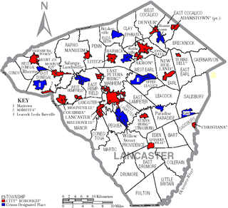
Transportation in Lancaster County, Pennsylvania has a long and variegated history. An early-settled part of the United States, and lying on the route between Philadelphia and Harrisburg, it has been the site of early experiments in canals, railroads, and highways. Before all these, at least ten Native American paths crossed parts of the county, many connecting with the Susquehannock village of Conestoga.

Pennsylvania Route 23 is an 81.14-mile-long (130.58 km) state highway in southeastern Pennsylvania. The route begins at PA 441 in Marietta and heads east to U.S. Route 1 at City Avenue on the border of Lower Merion Township and Philadelphia. PA 23 begins at Marietta in Lancaster County and continues east to Lancaster, where it passes through the city on a one-way pair of streets and intersects US 222 and US 30. East of Lancaster, the route runs through agricultural areas in Pennsylvania Dutch Country, serving Leola, New Holland, and Blue Ball, the latter location where it crosses US 322. PA 23 passes through the southern tip of Berks County and serves Morgantown, where a ramp provides access to Interstate 176 (I-176). The route runs through northern Chester County and serves Elverson, Bucktown, Phoenixville, and Valley Forge. PA 23 continues into Montgomery County and intersects US 422 in King of Prussia and US 202 in Bridgeport. The route follows the Schuylkill River to West Conshohocken, where it has access to I-76 and I-476, before it continues southeast through Lower Merion Township to US 1, which there is running on the border between Montgomery County and Philadelphia. The portion of PA 23 between Blue Ball and west of Morgantown is designated the Conestoga Ridge Byway, a Pennsylvania Scenic Byway.

Pennsylvania Route 41 is a 22-mile-long (35 km) state highway located in southeastern Pennsylvania, United States. The southern terminus of the route is at the Delaware state line in Kennett Township, where the road continues as Delaware Route 41. The northern terminus is at U.S. Route 30 in Gap. PA 41 runs along a two-lane undivided road called Gap Newport Pike, passing through mostly rural areas of Chester and Lancaster counties and serving Avondale, Chatham, Cochranville, and Atglen. The route serves as part of the main road linking Wilmington, Delaware to Lancaster, Pennsylvania.

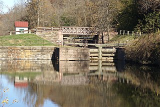
Mont Clare is a village in Upper Providence Township, Montgomery County, Pennsylvania. The village is located on the left bank of the Schuylkill River opposite Phoenixville and Chester Copunty. Mont Clare is at the site of the former Jacobs' ford. Mont Clare hosts the only functional lock and one of only two remaining watered stretches of the Schuylkill Canal. Mont Clare was the birthplace of the infamous outlaw Sundance Kid.

Pennsylvania Route 113 is a 46.9-mile-long (75.5 km) state route in eastern Pennsylvania. The southern terminus of the route is at U.S. Route 30 Business in Downingtown. Its northern terminus is at PA 611 in Tinicum Township. The route is signed as north–south although its exact alignment follows a northeast-southwest routing. The route serves Chester, Montgomery, and Bucks counties, passing through Lionville, Phoenixville, Trappe, Skippack, Harleysville, Souderton, and Silverdale along the way.

U.S. Route 322 is a spur of US 22, running from Cleveland, Ohio, east to Atlantic City, New Jersey. In the U.S. state of Pennsylvania, the route runs from the Ohio state line in West Shenango Township southeast to the Commodore Barry Bridge over the Delaware River in Chester, at which point the route crosses into New Jersey. The route passes near or through several cities, including Meadville, DuBois, State College, and Harrisburg. US 322 in Pennsylvania is named the 28th Division Highway in honor of the 28th Infantry Division.

Saint Peters is a community located in Chester County, Pennsylvania. The village is a historic 19th century industrial 'company village' at the Falls of French Creek in Warwick Township. The village is located in the Hopewell Big Woods.
The Pickering Valley Railroad was a short line railroad in Chester County, Pennsylvania. It ran from Phoenixville to Byers, near Eagle, in Upper Uwchlan Township, a distance of approximately 11 miles (18 km), over which distance it gained 316 feet (96 m) in elevation. Operated as a unit of the Reading Railroad, the Pickering Valley was not a great success; passenger service was discontinued in 1934, and most of the line was abandoned in 1948. The remainder of the line was closed in the 1980s; little remains today.

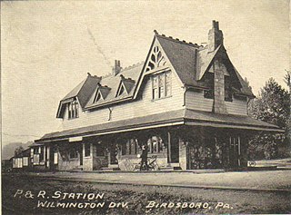
The Reading Company used two passenger railway stations in or near Birdsboro, Pennsylvania. The Philadelphia and Reading Railroad built a station on its Main Line in Exeter Township, on the opposite side of the Schuylkill River from Birdsboro. The Wilmington and Northern Railroad established a freight line to Birdsboro in 1870, but it was not until after its merger with the Reading Company that its passenger station was built in the borough.
Plymouth, Pennsylvania sits on the west side of Pennsylvania's Wyoming Valley, wedged between the Susquehanna River and the Shawnee Mountain range. Just below the mountain are hills that surround the town and form a natural amphitheater that separates the town from the rest of the valley. Below the hills, the flat lands are formed in the shape of a frying pan, the pan being the Shawnee flats, once the center of the town's agricultural activities, and the handle being a spit of narrow land extending east from the flats, where the center of town is located. At the beginning of the 19th century, Plymouth's primary industry was agriculture. However, vast anthracite coal beds lay below the surface at various depths, and by the 1850s, coal mining had become the town's primary occupation.
The Jersey Shore, Pine Creek and State Line Railroad was a paper railroad planned in northern Pennsylvania.
The Pithole Valley Railway was an ephemeral short line railroad in Venango County, Pennsylvania, constructed as a result of the Pennsylvania oil rush. The railroad was originally constructed in 1865 between Oil City, Pennsylvania, a local oil transportation hub, and the boomtown of Pithole, Pennsylvania. Constructed under the charter of the Clarion Land and Improvement Company, it was informally known as the Oil City and Pithole Branch Railroad. Although it was generally supported by the broad gauge Atlantic and Great Western Railway, it was built to standard gauge. Conflict with the Warren and Franklin Railway over the right-of-way along the Allegheny River led to a lawsuit which, in 1866, declared that the Oil City and Pithole had no right to operate along the river from Oleopolis, Pennsylvania to Oil City. That part of the line was sold to the Warren and Franklin, leaving the Oil City and Pithole with a 7-mile (10 km) line running north from Oleopolis to Pithole along Pithole Creek.

William Preston Snyder was an American physician and politician who served as President Pro Tempore of the Pennsylvania Senate from 1899–1902 and Pennsylvania Auditor General from 1904–1907. He was a member of the Republican Party from Chester County. In 1908, Snyder was convicted in a graft scandal involving the furnishing of the Pennsylvania State Capitol and received a two-year prison sentence for conspiracy to defraud the state.


