
Reservoir Dogs is a 1992 American independent crime film written and directed by Quentin Tarantino in his feature-length debut. It stars Harvey Keitel, Tim Roth, Chris Penn, Steve Buscemi, Lawrence Tierney, Michael Madsen, Tarantino, and Edward Bunker, as diamond thieves whose planned heist of a jewelry store goes terribly wrong. The film depicts the events before and after the heist. Kirk Baltz, Randy Brooks and Steven Wright also play supporting roles. It incorporates many motifs that have become Tarantino's hallmarks: violent crime, pop culture references, profanity, and nonlinear storytelling.

The West Branch Delaware River is one of two branches that form the Delaware River. It is approximately 90 mi (144 km) long, and flows through the U.S. states of New York and Pennsylvania. It winds through a mountainous area of New York in the western Catskill Mountains for most of its course, before joining the East Branch along the northeast border of Pennsylvania with New York. Midway or so it is empounded by the Cannonsville Dam to form the Cannonsville Reservoir, both part of the New York City water supply system for delivering drinking water to the City.
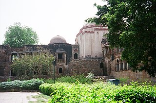
Hauz Khas Complex in Hauz Khas, South Delhi houses a water tank, an Islamic seminary, a mosque, a tomb and pavilions built around an urbanized village with medieval history traced to the 13th century of Delhi Sultanate reign. It was part of Siri, the second medieval city of India of the Delhi Sultanate of Alauddin Khalji Dynasty (1296–1316). The etymology of the name Hauz Khas in Farsi is derived from the words ‘Hauz’: "water tank" and ‘Khas’:"royal"- the "Royal tank". The large water tank or reservoir was first built by Allauddin Khilji to supply water to the inhabitants of Siri. The tank was de–silted during the reign of Firuz Shah Tughlaq (1351–88). Several buildings and tombs were built overlooking the water tank or lake. Firuz Shah's tomb pivots the L–shaped building complex which overlooks the tank.
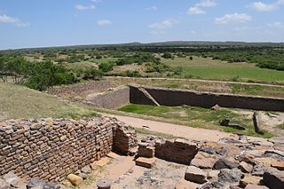
Dholavira is an archaeological site at Khadirbet in Bhachau Taluka of Kutch District, in the state of Gujarat in western India, which has taken its name from a modern-day village 1 kilometre (0.62 mi) south of it. This village is 165 km (103 mi) from Radhanpur. Also known locally as Kotada timba, the site contains ruins of an ancient Indus Valley Civilization/Harappan city. Dholavira’s location is on the Tropic of Cancer. It is one of the five largest Harappan sites and most prominent archaeological sites in India belonging to the Indus Valley Civilization. It is also considered as having been the grandest of cities of its time. It is located on Khadir bet island in the Kutch Desert Wildlife Sanctuary in the Great Rann of Kutch. The 47 ha quadrangular city lay between two seasonal streams, the Mansar in the north and Manhar in the south. The site was occupied from c.2650 BCE, declining slowly after about 2100 BCE. It was briefly abandoned then reoccupied until c.1450 BCE.

The Ashokan Reservoir is a reservoir in Ulster County, New York. The reservoir is in the eastern end of the Catskill Park, and is one of several in the region created to provide the City of New York with water. It is the city's deepest reservoir, 190 feet (58 m) deep near the dam at the former site of Bishop Falls.
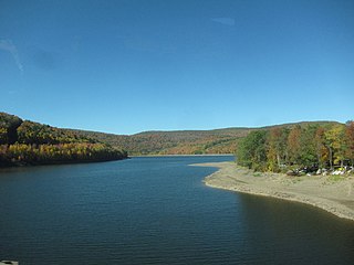
The Pepacton Reservoir, also known as the Downsville Reservoir, is a reservoir in Delaware County, New York on the East Branch of the Delaware River in the Catskill Mountains of New York. Part of the New York City water supply system, it was formed by the construction of Downsville Dam, and empounds over one-quarter of the East Branch's flow.
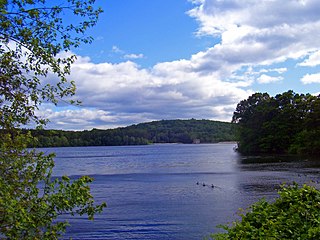
Titicus Reservoir is one of 12 in the New York City water supply system's Croton Watershed. It is located in the Town of North Salem in Westchester County, 30 miles (48 km) north of the city of New York.

The Bog Brook Reservoir is a 379-acre (153 ha) reservoir in the Croton Watershed in southern New York State, part of the New York City water supply system. It is located in the town of Southeast in Putnam County, approximately 38 miles (61 km) north of New York City. It was formed by the damming of Bog Brook, a small tributary of the East Branch of the Croton River. The reservoir was put into service in 1892, making it one of the older in the system.

The Cross River Reservoir is a reservoir in the New York City water supply system located directly east and north of the northern Westchester County, New York, village of Katonah. Part of the system's Croton Watershed, it lies within the towns of Bedford, Lewisboro, and Pound Ridge, about 1 mile (1.6 km) east of the village of Katonah, and over 25 mi (40 km) north of New York City. It was constructed around the start of the 20th century by impounding the Cross River, a tributary of the Croton River, which eventually flows into the Hudson River.

The Croton Falls Reservoir is a reservoir in the New York City water supply system in the Putnam County, New York townships of Carmel, and Southeast, roughly 50 miles (80 km) north of New York City. Part of the system's Croton Watershed, it was formed by impounding the West Branch and Middle Branch of the Croton River, tributaries of the Croton River, which flows into the Hudson River.

The Muscoot Reservoir is a reservoir in the New York City water supply system in northern Westchester County, New York, located directly north of the village of Katonah. Part of the system's Croton Watershed, it is 25 miles north of the City. It was constructed at the beginning of the 19th century by impounding the Muscoot River, a tributary of the Croton River, in turn a tributary of the Hudson River.

The New Croton Reservoir is a reservoir in Westchester County, New York, part of the New York City water supply system lying approximately 22 miles (35 km) north of New York City. It is the collecting point for water from all reservoirs in the Croton Watershed.

New York State Route 10 (NY 10) is a north–south state highway in the Central New York and North Country regions of New York in the United States. It extends for 155 miles (249 km) from the Quickway (NY 17) in Deposit, Delaware County to NY 8 at Higgins Bay, a hamlet in the Hamilton County town of Arietta. NY 10 formally began concurrent with NY 8, until NY 8 was truncated to end at the northern end of the overlap by 2017. While NY 8 follows a more westerly alignment between Deposit and Higgins Bay via Utica, NY 10 veers to the east, serving Delhi, Cobleskill, and Canajoharie. Along the way, the road intersects Interstate 88 (I-88) near Cobleskill and U.S. Route 20 (US 20) in Sharon Springs.

Highland Park is a park located in Brooklyn, New York City, on the border with Queens. The Brooklyn neighborhood to its south is commonly regarded as Cypress Hills which is part of the East New York neighborhood. The Queens neighborhoods to the north are Glendale and Ridgewood.

The Jacqueline Kennedy Onassis Reservoir is a decommissioned reservoir in Central Park in the borough of Manhattan, New York City, stretching from 86th to 96th Streets.

Dhosi Hill is an extinct volcano, standing alone at the north-west end of the Aravalli mountain range, of which it is a part, with height varying from about 345 to 470 meters from the surrounding land and 740 meters from the sea level. It has temple, pond, fort and caves on the top and forest around it. The Aravalli range is a Precambrian Malani igneous suite of rocks that have been dated at 732 Ma BP.

Surajkund is an ancient reservoir of the 10th century located on Southern Delhi Ridge of Aravalli range in Faridabad city of Haryana state about 8 km from South Delhi. Surajkund is an artificial Kund built in the backdrop of the Aravalli hills with an amphitheatre shaped embankment constructed in semicircular form. It is said to have been built by the king Surajpal of Tomar dynasty in the 10th century. Tomar, a younger son of Anangpal Tomar - the ruler of Delhi, was a sun worshipper and he had therefore built a Sun temple on its western bank. Surajkund is known for its annual fair "Surajkund International Craft Mela", 2015 edition of this fair was visited by 1.2 million visitors including 160,000 foreigners with more than 20 countries participating in it.

Hauz Khas is an affluent neighborhood in South Delhi, its heart being the historic Hauz Khas Complex. Well known in medieval times, the Hauz Khas village has amazing buildings built around the reservoir. There are remnants of Islamic architecture roughly colored by splotches of urban culture. It is centrally located and offers both rural Hauz Khas Village and urban Hauz Khas Enclave, Market environments. Hauz Khas is surrounded by Green Park, SDA to the west, Gulmohar Park towards the north, Sarvapriya Vihar towards the south and Asiad Village and Siri Fort to the east.
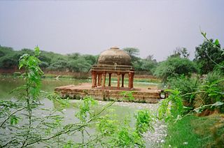
Hauz-i-Shamsi is a water storage reservoir or tank built by Iltutmish of the Slave Dynasty in 1230 CE, at a location revealed to him in a dream by the Islamic prophet Muhammad. A palace called the Jahaz Mahal was built on the eastern edge of the same reservoir during the Lodi dynasty period in the 16th century as a retreat or Inn for use by pilgrims. Also at the edge of Hauz is the tomb of 17th-century Persian writer in the Mughal court, Abdul-Haqq Dehlavi. The monuments are situated in Mehrauli, Delhi.

The Anangpur Dam, located close to the Anagpur village in Faridabad district of Haryana, India, is 2 kilometres (1.2 mi) away from the more famous Surajkund. It is also known as Gravity Dam. This unique Indian hydraulic engineering structure was built during the reign of King Anangpal of the Tomar dynasty in 8th century. It is approachable by road from Delhi from the Delhi - Mathura road. The ruins of the fortifications found in Anangpur village establishes by an inference that it was built by Anangpal as part of the Lal Kot that was developed as the first city of Delhi in the 8th century. It is an important biodiversity area within the Northern Aravalli leopard wildlife corridor stretching from Sariska Tiger Reserve to Delhi. Historical place around sanctuary are Badkhal Lake, 10th century ancient Surajkund reservoir, Damdama Lake, Tughlaqabad Fort and Adilabad ruins, Chhatarpur Temple. It is contiguous to the seasonal waterfalls in Pali-Dhuaj-Kot villages of Faridabad, the scared Mangar Bani and the Asola Bhatti Wildlife Sanctuary. There are several dozen lakes formed in the abandoned open pit mines in and around the area.


