The city of Cooper is the county seat of Delta County, in the U.S. state of Texas. Located between the north and south forks of the Sulphur River, Cooper is the largest settlement in Delta County. As of the U.S. Census of 2010, Cooper had a population of 1,969.

Dealey Plaza is a city park in the West End Historic District of downtown Dallas, Texas. It is sometimes called the "birthplace of Dallas". It was also the location of the assassination of John F. Kennedy in 1963; 30 minutes after the shooting, Kennedy was pronounced dead at Parkland Memorial Hospital. The Dealey Plaza Historic District was named a National Historic Landmark on the 30th anniversary of the assassination, to preserve Dealey Plaza, street rights-of-way, and buildings and structures by the plaza visible from the assassination site, that have been identified as witness locations or as possible locations for assassin(s).

Floyd Casey Stadium was a stadium in Waco, Texas. The stadium was used for 64 seasons before being replaced by McLane Stadium in 2014. It was primarily used for football, and was the home field of the Baylor Bears. The stadium, located about four miles from the Baylor University campus, cost $1.8 million to build and sat 50,000 people. Originally named Baylor Stadium, it opened in 1950 with a Baylor game against the Houston Cougars. On December 7, 2013, Baylor played its last game in the stadium, against the Texas Longhorns, where the attendance record of 51,728 was established. Baylor won 19 of its final 20 games played at the stadium.

The Fort Worth Convention Center is a convention center and indoor arena located in Sundance Square in Fort Worth, Texas. The complex opened on September 30, 1968, and was expanded in 1983, 2002 and 2003.

Moody Coliseum is a 7,000-seat multi-purpose arena in University Park, Texas. The arena opened in 1956. It is home to the Southern Methodist University Mustangs basketball teams and volleyball team. It was also home to the Dallas Chaparrals and Texas Chaparrals of the American Basketball Association before they moved to San Antonio, Texas, as the San Antonio Spurs. It was also later the home for the Dallas Diamonds of the Women's Professional Basketball League.
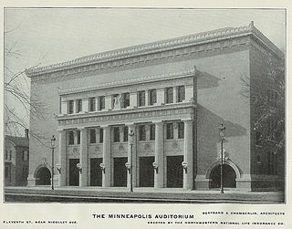
Minneapolis Auditorium was an indoor arena in Minneapolis, Minnesota. It hosted the NBA's Minneapolis Lakers from 1947 until they moved to the Minneapolis Armory in 1959. The arena held 10,000 people and was built in 1927. The building fell into obscurity after the opening of the Met Center in suburban Bloomington. It was demolished in 1988 to make way for the Minneapolis Convention Center.

Denver Auditorium Arena was an indoor arena located at the corner of 13th and Champa Streets in Denver, Colorado. It was constructed as the Denver Municipal Auditorium in 1908 during the administration of Denver Mayor Robert W. Speer. The building was opened on July 7, 1908, and was the site of the 1908 Democratic National Convention.
New York State Route 105 (NY 105) is a 3.41-mile (5.49 km) state highway located within Nassau County, New York, in the United States. It begins in the town of Hempstead at an intersection with NY 106 in North Bellmore that also serves as that route's southern terminus. From here, it runs east through North Wantagh to an interchange with NY 135 before crossing into the town of Oyster Bay and ending at a junction with NY 107 in Massapequa. Jerusalem Avenue continues west past the route's western terminus as a county-maintained road to Hempstead and east as a town road to Massapequa State Park. NY 105 was assigned in the early 1930s.
New York State Route 134 (NY 134) is a 6.35-mile (10.22 km) state highway in the western part of Westchester County, New York, in the United States. It begins at an intersection with NY 133 in the village of Ossining and heads northeast to the hamlet of Kitchawan, located adjacent to the New Croton Reservoir in the town of Yorktown. From here, the route turns southeast to reach its east end at a junction with NY 100. The highway passes the Thomas J. Watson Research Center, one of the main research headquarters for IBM, just east of an interchange with the Taconic State Parkway.
New York State Route 102 (NY 102) is an east–west state highway in Nassau County, New York, in the United States. It is little more than an alternate route of NY 24 through the town of Hempstead. NY 102 leaves NY 24 in West Hempstead and follows Front Street through the village of Hempstead and Uniondale before rejoining NY 24 in East Meadow. The portion of NY 102 west of William Street is maintained by Nassau County and is unsigned while the remainder of the highway is maintained by the New York State Department of Transportation and signed. NY 102 goes under the Meadowbrook State Parkway, but has no connecting ramps to or from the parkway. It does, however have a right-of-way for a formerly proposed eastbound lane.
Cooper Independent School District is a public school district based in Cooper, Texas (USA). Located in Delta County, a very small portion of the district extends into Hunt County.

Peoria Civic Center is a convention center in downtown Peoria, Illinois. Designed by Pritzker Prize winning architect Philip Johnson, it has an arena, theater, exhibit hall and meeting rooms. It opened in 1982 and completed an expansion to its lobby and meeting facilities in 2007. On the grounds of the Peoria Civic Center sits the massive "Sonar Tide," the last and largest sculpture of the pioneer of abstract minimalism Ronald Bladen.

Texas Trust CU Theatre is a concert hall located in Grand Prairie, Texas, 16 miles west of Dallas and 24 miles east of Fort Worth. It is near Lone Star Park and AirHogs Stadium. The theatre is currently operated by AEG and owned by the City of Grand Prairie.

Ruskin Hall is a residence hall at the University of Pittsburgh and a contributing property to the Schenley Farms National Historic District. Constructed in 1921–22 by H. L. Stevens & Company, with an annex added in 1925–26, it is an eight-story building which is located between the Music Building and Information Sciences Building between Ruskin and Bellefield Avenues near Fifth Avenue on Pitt's main campus in the Oakland neighborhood of Pittsburgh, Pennsylvania. Ruskin Hall recently underwent a $19.4 million conversion and renovation from medical student housing into undergraduate apartment-style housing that opened in 2008.

The first Lincoln County Courthouse, also known as the Pioche Courthouse and the Old Lincoln County Courthouse, in Pioche, Nevada earned the title "Million Dollar Courthouse" after it cost $75,000 to build in 1872, for a relatively small building. With added costs attributed to finance charges and fiscal mismanagement, the cost in 1872 dollars came to over $800,000. The debt incurred by the county was not retired until 1938, when the new courthouse was under construction.

The Music Hall at Fair Park performing arts theater in Dallas, Texas's Fair Park that opened in 1925.
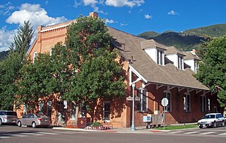
Aspen City Hall, known in the past as Armory Hall, Fraternal Hall, is located at the intersection of South Galena Street and East Hopkins Avenue in Aspen, Colorado, United States. It is a brick building dating to the 1890s. In 1975 it was listed on the National Register of Historic Places.
U.S. Route 60 and U.S. Route 62 (US 60/US 62) run for a very short distance within the state of Illinois. The highways run concurrently for their entire existence within the state. The joint highway runs around Fort Defiance in Cairo, from the Cairo Mississippi River Bridge over the Mississippi River east to the Cairo Ohio River Bridge over the Ohio River; the Ohio River Bridge also carries US 51. The bridges cross the two rivers just north of the mouth of the Ohio.
The Waterman Gymnasium was the first on-campus gymnasium at the University of Michigan in Ann Arbor, Michigan. The building was the first home of the Michigan Wolverines men's basketball team. The building stood at the corner of North University Avenue and East University Avenue, at the northeast corner of the original campus.
The Dixie Overland Highway was an auto trail across the southern United States. It was conceived in July 1914 by the Automobile Club of Savannah, which envisioned a practical all-year driving route from Georgia to California. It was originally developed as a cross-country route, from the Pacific Ocean to the Atlantic Ocean making history as the first ever ocean to ocean highway route. In 1925, the federal Joint Board on Interstate Highways created U.S. Route 80, largely following the route of the Dixie Overland Highway.