Related Research Articles

Wrexham County Borough is a county borough, with city status, in the north-east of Wales. It borders the English ceremonial counties of Cheshire and Shropshire to the east and south-east respectively along the England–Wales border, Powys to the south-west, Denbighshire to the west and Flintshire to the north-west. The city of Wrexham is the administrative centre. The county borough is part of the preserved county of Clwyd.

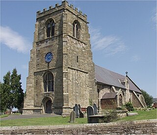
Ruabon is a village and community in Wrexham County Borough, Wales. The name comes from Rhiw Fabon, rhiw being the Welsh word for "slope" or "hillside" and Fabon being a mutation from St Mabon, the original church name, of earlier, Celtic origin. An older English spelling, Rhuabon, can sometimes be seen.

Coedpoeth is a village and community in Wrexham County Borough, Wales. The built-up area with Minera had a population of 5,723 in the 2011 census.
St Martin's is a village and civil parish in Shropshire, England, just north of Oswestry and east of Chirk, Wales on the England–Wales border.

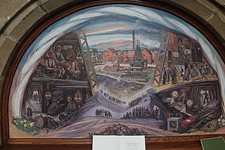
Bersham is a village in Wrexham County Borough, Wales, that lies next to the River Clywedog, and is in the community of Esclusham. Bersham was historically a major industrial centre of the area, but despite this the village still retains a rural feeling.
The South Yorkshire Coalfield is so named from its position within Yorkshire. It covers most of South Yorkshire, West Yorkshire and a small part of North Yorkshire. The exposed coalfield outcrops in the Pennine foothills and dips under Permian rocks in the east. Its most famous coal seam is the Barnsley Bed. Coal has been mined from shallow seams and outcrops since medieval times and possibly earlier.
Rhostyllen is a village in Wrexham County Borough, Wales, south-west of the city of Wrexham. At the time of the 2001 census, area Wrexham 014A, which includes Rhostyllen itself, had a population of 1,383 in 599 households.

The Cheadle Coalfield is a coalfield in the United Kingdom. Centred on the town of Cheadle, Staffordshire, and its outlying villages it lies to the east of Stoke-on-Trent and the much larger North Staffordshire Coalfield. The area has been mined for many years, with documentary evidence from Croxden Abbey citing coal mining in the 13th century.
Gresford Colliery was a coal mine located a mile from the North Wales village of Gresford, near Wrexham.

The North Wales Mineral Railway was formed to carry coal and ironstone from the mineral-bearing area around Wrexham to the River Dee wharves. It was extended to run from Shrewsbury and formed part of a main line trunk route, under the title the Shrewsbury and Chester Railway. It opened in 1846 from Chester to Ruabon, and in 1848 from Ruabon to Shrewsbury. It later merged with the Great Western Railway.
Esclusham is a community and electoral ward in Wrexham County Borough, Wales.

The Flintshire Coalfield in north-east Wales is one of the smaller British coalfields. It is in the county of Flintshire and extends from the Point of Ayr in the north, along the Dee Estuary through Connah's Quay to Caergwrle in the south. A small part extends onto the Wirral i.e. English coast of the estuary at Neston, Cheshire which was the site of a coalmine for a period. The coal-bearing strata continue southwards of Caergwrle as the Denbighshire Coalfield. Together the two coalfields are known as the North Wales Coalfield.
The Ingleton Coalfield is in North Yorkshire, close to its border with Lancashire in north-west England. Isolated from other coal-producing areas, it is one of the smallest coalfields in Great Britain.
The Machrihanish Coalfield is a coalfield on the Kintyre peninsula in southwest Scotland. It is one of the smallest British coalfields. With the exception of a thin coal beneath the Lyoncross Limestone in the overlying Upper Limestone Formation, all of the coal-bearing strata are found within the Limestone Coal Formation, a subdivision of the Clackmannan Group; all being strata of Namurian age. There are numerous seams of which the Main Coal is the principal one, being some 3 to 4m thick. A further, higher seam known as the Kilkivan Coal has also been worked. The full sequence is:

The Manchester Coalfield is part of the South Lancashire Coalfield, the coal seams of which were laid down in the Carboniferous Period. Some easily accessible seams were worked on a small scale from the Middle Ages, and extensively from the beginning of the Industrial Revolution in the early 19th century until the last quarter of the 20th century. The Coal Measures lie above a bed of Millstone Grit and are interspersed with sandstones, mudstones, shales, and fireclays. The Lower Coal Measures occupy the high ground of the West Pennine Moors above Bolton and are not worked in the Manchester Coalfield. The most productive of the coal measures are the lower two thirds of the Middle Coal Measures where coal is mined from seams between the Worsley Four Foot and Arley mines. The deepest and most productive collieries were to the south of the coalfield. The coalfield is affected by the northwest to southeast aligned Pendleton Fault along the Irwell Valley and the Rossendale Valley anticline. The Coal Measures generally dip towards the south and west. Numerous other smaller faults affect the coalfield. The Upper Coal Measures are not worked in the Manchester Coalfield.
The North Wales Coalfield comprises the Flintshire Coalfield in the north and the Denbighshire Coalfield in the south. It extends from Point of Ayr in the north, through the Wrexham area to Oswestry in Shropshire in the south. A much smaller area on Anglesey where coal was formerly mined is not usually considered to form a part of the coalfield, although it is geographically in the North Wales region.
The Bristol Coalfield is a geologically complex coalfield in the west of England. Comprising the coal-bearing rocks arranged around the Coalpit Heath Syncline and Kingsdown Anticline, it extends beneath the eastern parts of the city of Bristol and northwards through southern Gloucestershire. The coalfield is sometimes referred to together with the Somerset Coalfield, which lies to its south, as the Bristol and Somerset Coalfield. There are also two outlying coal-mining areas, the Severn Coalfield and the Nailsea Basin which are described below.
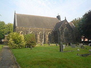
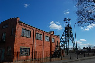
Bersham Colliery was a large coal mine located near Rhostyllen in Wrexham, Wales. The mine accessed seams found in the Denbighshire Coalfield.
The North Wales Miners' Association was a trade union representing coal miners in Wales.

The coal industry in Wales played an important role in the Industrial Revolution in Wales. Coal mining in Wales expanded in the 18th century to provide fuel for the blast furnaces of the iron and copper industries that were expanding in southern Wales. The industry had reached large proportions by the end of that century, and then further expanded to supply steam-coal for the steam vessels that were beginning to trade around the world. The Cardiff Coal Exchange set the world price for steam-coal and Cardiff became a major coal-exporting port. The South Wales Coalfield was at its peak in 1913 and was one of the largest coalfields in the world. It remained the largest coalfield in Britain until 1925. The supply of coal dwindled, and pits closed in spite of a UK-wide strike against closures. Aberpergwm Colliery is the last deep mine in Wales.
References
- 1 2 "Mines of the North Wales Coalfield". North Wales Miners Association Trust Ltd. Retrieved 25 April 2016.
- ↑ Royle, Edward (1998). Issues of Regional Identity: In Honour of John Marshall. Manchester University Press. pp. 210–213. ISBN 978-0-7190-5028-2.
- ↑ WCBC: Bersham Colliery Mining Museum
- ↑ "Bedrock Geology: UK South, 1:625,000 scale geological map (5th edn)". British Geological Survey. 2007.
{{cite web}}: Missing or empty|url=(help)