Until 1974, Flintshire, also known as the County of Flint, was an administrative county in the north-east of Wales, later classed as one of the thirteen historic counties of Wales.

Until 1974, Denbighshire, or the County of Denbigh, was an administrative county in the north of Wales, later classed as one of the thirteen historic counties of Wales. It was a maritime county, that was bounded to the north by the Irish Sea, to the east by Flintshire, Cheshire and Shropshire, to the south by Montgomeryshire and Merionethshire, and to the west by Caernarfonshire.
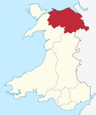
Clwyd is a preserved county of Wales, situated in the north-east corner of the country; it is named after the River Clwyd, which runs through the area. To the north lies the Irish Sea, with the English ceremonial counties of Cheshire to the east and Shropshire to the south-east. Powys and Gwynedd lie to the south and west respectively. Clwyd also shares a maritime boundary with Merseyside along the River Dee. Between 1974 and 1996, a slightly different area had a county council, with local government functions shared with six district councils. In 1996, Clwyd was abolished, and the new principal areas of Conwy County Borough, Denbighshire, Flintshire and Wrexham County Borough were created; under this reorganisation, "Clwyd" became a preserved county, with the name being retained for certain ceremonial functions.

The River Dee is a river flowing through North Wales, and through Cheshire, England, in Great Britain. The length of the main section from Bala to Chester is 113 km and it is largely located in Wales. The stretch between Aldford and Chester is within England, and two other sections form the border between the two countries.

Chirk is a town and community in Wrexham County Borough, Wales, 10 miles south of Wrexham, between it and Oswestry. At the 2011 census, it had a population of 4,468. Historically in the traditional county of Denbighshire, and later Clwyd, it has been part of Wrexham County Borough since a local government reorganisation in 1996. The border with the English county of Shropshire is immediately south of the town, on the other side of the River Ceiriog.

The Maelor is an area of north-east Wales along the border with England. It is now entirely part of Wrexham County Borough. The name Maelor is an old Welsh word: it can be translated as "land of the prince", from mael ("prince") and llawr.

Wrexham County Borough is a county borough, with city status, in the north-east of Wales. It borders the English ceremonial counties of Cheshire and Shropshire to the east and south-east respectively along the England–Wales border, Powys to the south-west, Denbighshire to the west and Flintshire to the north-west. The city of Wrexham is the administrative centre. The county borough is part of the preserved county of Clwyd.
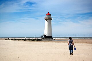
Point of Ayr is the northernmost point of mainland Wales. It is situated immediately to the north of Talacre in Flintshire, at the mouth of the Dee estuary. It is to the southwest of the Liverpool Bay area of the Irish Sea. It is the site of a RSPB nature reserve RSPB Dee Estuary Point of Ayr, and is part of Gronant and Talacre Dunes Site of Special Scientific Interest.

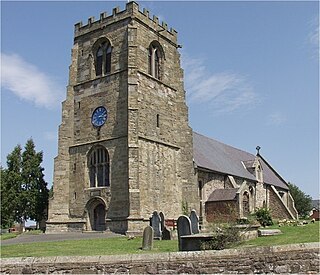
Ruabon is a village and community in Wrexham County Borough, Wales. The name comes from Rhiw Fabon, rhiw being the Welsh word for "slope" or "hillside" and Fabon being a mutation from St Mabon, the original church name, of earlier, Celtic origin. An older English spelling, Rhuabon, can sometimes be seen.
St Martin's is a village and civil parish in Shropshire, England, just north of Oswestry and east of Chirk, Wales on the England–Wales border.
The Point of Ayr Colliery Company was formed in 1883, and was the third company to attempt to extract coal from the North Wales Coalfield using a pit head at Point of Ayr, in Flintshire, Wales. The two previous attempts were carried out by the Prestatyn Coal Company, 1865, under the direction of Lord Mostyn, owner of the nearby Mostyn Colliery, and the Western Mostyn Colliery Company, 1873.
Gresford Colliery was a coal mine located a mile from the North Wales village of Gresford, near Wrexham.

The North Wales Mineral Railway was formed to carry coal and ironstone from the mineral-bearing area around Wrexham to the River Dee wharves. It was extended to run from Shrewsbury and formed part of a main line trunk route, under the title the Shrewsbury and Chester Railway. It opened in 1846 from Chester to Ruabon, and in 1848 from Ruabon to Shrewsbury. It later merged with the Great Western Railway.

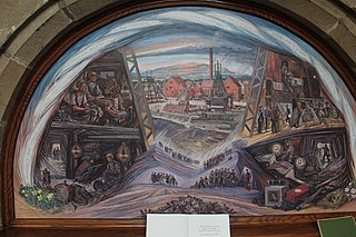
The Flintshire Coalfield in north-east Wales is one of the smaller British coalfields. It is in the county of Flintshire and extends from the Point of Ayr in the north, along the Dee Estuary through Connah's Quay to Caergwrle in the south. A small part extends onto the Wirral i.e. English coast of the estuary at Neston, Cheshire which was the site of a coalmine for a period. The coal-bearing strata continue southwards of Caergwrle as the Denbighshire Coalfield. Together the two coalfields are known as the North Wales Coalfield.
The Denbighshire Coalfield in the historic county of Denbighshire in north-east Wales is one of the smaller British coalfields. It extends from near Caergwrle in the north, southwards through Wrexham, Ruabon and Rhosllannerchrugog to Chirk in the south. A small part extends into Shropshire around Oswestry. Beyond Caergwrle the coal-bearing strata continue northwards as the Flintshire Coalfield. Together the two coalfields are known as the North Wales Coalfield.
The North Wales Miners' Association was a trade union representing coal miners in Wales.

Benjamin Gummow was an architect who worked from Ruabon near Wrexham in Wales. He worked almost exclusively for Sir Watkin Williams Wynn of Wynnstay, Ruabon and the Grosvenor family of Eaton Hall near Chester. He was born in St Endellion in Cornwall in 1766 and died at Ruabon in March 1844.

The coal industry in Wales played an important role in the Industrial Revolution in Wales. Coal mining in Wales expanded in the 18th century to provide fuel for the blast furnaces of the iron and copper industries that were expanding in southern Wales. The industry had reached large proportions by the end of that century, and then further expanded to supply steam-coal for the steam vessels that were beginning to trade around the world. The Cardiff Coal Exchange set the world price for steam-coal and Cardiff became a major coal-exporting port. The South Wales Coalfield was at its peak in 1913 and was one of the largest coalfields in the world. It remained the largest coalfield in Britain until 1925. The supply of coal dwindled, and pits closed in spite of a UK-wide strike against closures. Aberpergwm Colliery is the last deep mine in Wales.
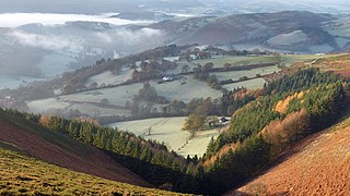
The Clwydian Range and Dee Valley is a designated Area of Outstanding Natural Beauty located in north-east Wales, covering the Clwydian Range, and the valley of the River Dee.

Plas Madoc is a housing estate and former electoral ward near Acrefair, in the Cefn community in Wrexham County Borough, Wales. It is located seven miles to the south-west of Wrexham, and contains The Land adventure playground, and a community-run leisure centre with a swimming pool. The area is one of the most deprived areas in Wales, and the fourth most deprived LSOA in Wrexham County Borough.

