Dente Italiano

Last updated
Dente Italiano
Monte-Pasubio Italienische Seite des Eselsrucken nach der Sprengung.JPG
Dente Italiano with the aftermath of the Austrian mine of March 13, 1918
Highest point
Elevation 2,220 m (7,280 ft)
Coordinates 45°47′40″N11°10′34″E / 45.794321°N 11.175982°E / 45.794321; 11.175982
Geography
Italy relief location map.jpg
Red triangle with thick white border.svg
Dente Italiano
Location of Dente Italiano
Location Trentino
Country Italy
Region Trentino-Alto Adige/Südtirol
Parent range Vicentine Alps

Dente Italiano (German: Italienische Platte) (2220 m) is one of the ridges of the Pasubio summit highlands in the Vicentine Alps.

Contents

Located on the line of ridges between the Cosmagnon basin and the Pasubio Alps, to the south the Damaggio pass separates it from Cima Palon, to the north the Denti pass (for the Austro-Hungarians Eselsrücken i.e. donkey's back) separates it from the Austrian Dente.

History

It was named so during World War I because it represented the front line at the highest part of the massif; while on the Austro-Hungarian side was the Austrian Dente.

The wartime events

Dente Italiano, at the beginning of World War I, became from the earliest days a strong point of the Royal Army on the Pasubio, occupied in the initial Austrian retreat to fortify the defense lines. However, during the Strafexpedition, the Habsburg Army advanced to the point of undermining Cima Palon, settling in early summer 1916 on the line between the Denti.

The battle of July 2, 1916, saw Lieutenant Salvatore Damaggio halt the enemy advance on the pass between Dente and Cima Palon, hence the name of the pass itself. [1] During the mine war, Dente Italiano was dug not only to provide firing positions and shelters for the Italian army, but also in an attempt to creep under enemy positions on the Austrian Dente [2] with the aim of blowing them up with explosives. However, the tunnels of Dente Italiano are often "counter-mine" tunnels, dug in a haphazard manner, without a precise plan, but following the sounds of the enemy's digging in an attempt to stop them. They therefore assume a tortuous course.

From September 29, 1917, to March 13, 1918, a total of ten mines were blasted, five by the Italians and as many by the Austro-Hungarians, hardly achieving the desired results: [3]

N.DateOriginExplosive chargeNotesCasualties
1September 29, 1917Austro-Hungarian mine500 kglandmine30 Italians [note 1]
2October 1, 1917Italian mine16.000 kgcaused a crater 40 m in diameter and 10 m deep in the pass of the Denti12 Austro-Hungarians
3October 22, 1917Italian mine1000 kglandmine0
4December 24, 1917Austro-Hungarian mine6.400 kgmine under the northern spike of the Dente Italiano50 Italians
5January 21, 1918Italian mine600 kglandmine0
6February 2, 1918Austro-Hungarian mine3.800 kgcaused serious damage to the Italian underground systemunknown
7February 13, 1918Italian mineunknownunintentionally caused the explosion of a second Italian mine6 Austro-Hungarians and 2 Italians
8February 24, 1918Austro-Hungarian mineunknownlandmine0
9March 5, 1918Italian mineunknownlandmine, provoked by the Austro-Hungarians in order to safely load the two blast chambers of the March 13 mine0
10March 13, 1918Austro-Hungarian mine50.000 Kgcaused the collapse of the northern part of the Dente Italiano40 Italians and some Austro-Hungarians

The Austro-Hungarian mine that burst at 4:30 a.m. on March 13, 1918 with its 50,000 kg of explosives, loaded into two blast chambers under Dente Italiano, was the largest mine and caused the collapse of the northern part of it, which is still clearly visible today. It took 7 days just to load the two chambers. [4]

The Austro-Hungarians' mine slightly anticipated an Italian mine that was to be detonated that same morning. [5] For this reason, a good part of the Italian garrison had already abandoned the Dente when the Austro-Hungarian mine exploded, and the number of casualties was small. The gas explosions lasted for hours; until 11 a.m. 30 explosions were counted, some of which also involved the Austrian Dente, claiming some casualties among the Austro-Hungarians as well. [6] [7]

Following the March 13 mine, the ground under the Denti pass became so unstable that no further digging was possible, thus ending the mine war involving the Italian and Austrian Dente. [8] The exact number of casualties from the mine war on the Denti varies in the literature. The figures were several times scaled down and are quite different from those published in the years immediately after the war, which spoke of hundreds and hundreds of casualties. [9] [10] The galleries of Dente Italiano are today partly collapsed, but accessible with due caution in their initial part. There is also the Papa Gallery that allowed an indoor connection with the nearby Cima Palon. In 1922 the Dente Italiano was proclaimed by royal decree a Sacred Zone, along with other areas of Pasubio. [11]

For the centenary of the Great War, some artifacts and tunnels of the Dente Italiano were recovered and various information signs installed. During this work the Ghersi walkway was also restored, named after General Giovanni Ghersi, from July 1917 General Papa's successor in command of the Pasubio sector. The Ghersi walkway connected the Damaggio pass with the so-called Bombarde ridge and the underlying Commando pass near the Roman Arch. [12] [13]

See also

Notes

  1. Among the victims was Engineer Captain Leopoldo Motti, creator of the 52 Tunnel Road.

Related Research Articles

<span class="mw-page-title-main">1st Army (Italy)</span> Italian Army field army, in World War I and II

The 1st Army was a Royal Italian Army field army, in World War I, facing Austro-Hungarian and German forces, and in World War II, fighting on the North African front.

<span class="mw-page-title-main">Battle of Vittorio Veneto</span> Battle during World War I (October–November 1918)

The Battle of Vittorio Veneto was fought from 24 October to 3 November 1918 near Vittorio Veneto on the Italian Front during World War I. After having thoroughly defeated Austro-Hungarian troops during the defensive Battle of the Piave River, the Italian army launched a great counter-offensive: the Italian victory marked the end of the war on the Italian Front, secured the dissolution of the Austro-Hungarian Empire and contributed to the end of the First World War just one week later. On 1 November, the new Hungarian government of Count Mihály Károlyi decided to recall all of the troops, who were conscripted from the territory of Kingdom of Hungary, which was a major blow for the Habsburg's armies. The battle led to the capture of over 5,000 artillery pieces and over 350,000 Austro-Hungarian troops, including 120,000 Germans, 83,000 Czechs and Slovaks, 60,000 South Slavs, 40,000 Poles, several tens of thousands of Romanians and Ukrainians, and 7,000 Austro-Hungarian loyalist Italians and Friulians.

<span class="mw-page-title-main">Battle of Asiago</span> Battle on the Italian Front during World War I

The Battle of Asiago(Battle of the Plateaux) or the Südtirol Offensive (in Italian: Battaglia degli Altipiani), nicknamed Strafexpedition ("Punitive expedition") by the Austro-Hungarian forces, was a major counteroffensive launched by the Austro-Hungarians on the territory of Vicentine Alps in the Italian Front on 15 May 1916, during World War I. It was an "unexpected" attack that took place near Asiago in the province of Vicenza (now in northeast Italy, then on the Italian side of the border between the Kingdom of Italy and Austria-Hungary) after the Fifth Battle of the Isonzo (March 1916).

<span class="mw-page-title-main">Battle of Mount Ortigara</span>

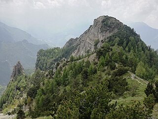
The Battle of Mount Ortigara was fought from 10 to 25 June 1917 between the Italian and Austro-Hungarian armies for possession of Mount Ortigara, in the Asiago Plateau.

<span class="mw-page-title-main">35 cm Marinekanone L/45 M. 16</span> Battleship gun

The 35 cm Marinekanone L/45 M. 16 was used by Austria-Hungary during World War I as a superheavy siege gun. Eleven of these had been ordered from Škoda Works before the war to equip the first unit of the Ersatz Monarch-class battleships that Austria had ordered. The ships were cancelled shortly after the outbreak of the war, but the guns continued in production.

<span class="mw-page-title-main">Col di Lana</span> Mountain in Italy

The Col di Lana is a mountain of the Fanes Group in the Italian Dolomites. The actual peak is called Cima Lana and situated in the municipality of Livinallongo del Col di Lana in the Province of Belluno, Veneto region.

<span class="mw-page-title-main">Legione Redenta</span>

The Legione Redenta was an Italian military formation that participated in the Siberian intervention during the Russian Civil War. It was formed from 2500 prisoners of war who had been captured by the Russians from the Austro-Hungarian Army.

Monte Cimone di Tonezza is a mountain of the Veneto, Italy. It has an elevation of 1,226 metres (4,022 ft).

<span class="mw-page-title-main">Cima Palon</span> Mountain in Italy

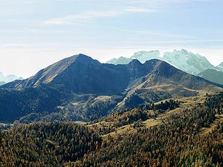
Cima Palon, also called Monte Pasubio, is the highest peak of the Pasubio group of Little Dolomites in Veneto, Italy. It has an elevation of 2,239 metres.

<span class="mw-page-title-main">Strada delle 52 Gallerie</span>

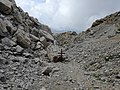
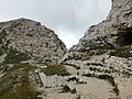
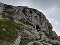
The Strada delle 52 Gallerie, also known as the 52 Tunnel Road, or Strada della Prima Armata is a military mule road built during World War I on the Pasubio massif in Veneto, Italy.

<span class="mw-page-title-main">Vicentine Alps</span> Mountain range of the Eastern Alps

The Vicentine Alps are a mountain range of the Eastern Alps in Trentino and the provinces of Verona and Vicenza. The mountains were named after the city of Vicenza which lies at their eastern edge. The highest point in the range is the Cima Dodici on the northern perimeter of the Vicentine Alps.

<span class="mw-page-title-main">Asiago War Memorial</span> World War I memorial in Asiago, Italy

The Asiago War Memorial is a World War I memorial located in the town of Asiago in the Province of Vicenza in the Veneto region of northeast Italy. Surrounded by mountains that were the site of several World War I battles, the monument houses the remains of over 50,000 Italian and Austro-Hungarian soldiers and is a popular destination for travelers to the region. In Italian the memorial is typically called Sacrario Militare di Asiago or Sacrario Militare del Leiten. Leiten is the name of the hill on which the memorial sits.

<span class="mw-page-title-main">Mines on the Italian front (World War I)</span>

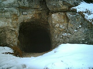
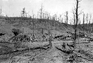
The mines on the Italian front during the First World War comprised a series of underground explosive charges of varying sizes, secretly planted between 1916 and 1918 by Austro-Hungarian and Italian tunneling units beneath their enemy's lines along the Italian front in the Dolomite section of the Alps.

<span class="mw-page-title-main">Alpini and mountain artillery formations in World War I</span>

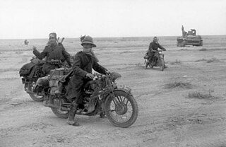
The Alpini are a specialised mountain warfare infantry corps of the Italian Army, which distinguished itself in World War I fighting in the Alps against Austro-Hungarian Kaiserjäger and the German Alpenkorps. The Alpini were supported by the Mountain Artillery, which both share the Cappello Alpino as identifying symbol. Below follow tables listing the regiments, battalions and groups, companies and batteries of the Alpini and Mountain Artillery active in World War I.

<span class="mw-page-title-main">White War</span> High-altitude mountain warfare in the Italian front of World War I

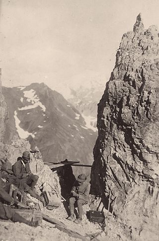
The White War is the name given to the fighting in the high-altitude Alpine sector of the Italian front during the First World War, principally in the Dolomites, the Ortles-Cevedale Alps and the Adamello-Presanella Alps. More than two-thirds of this conflict zone lies at an altitude above 2,000m, rising to 3905m at Mount Ortler. In 1917 New York World correspondent E. Alexander Powell wrote: “On no front, not on the sun-scorched plains of Mesopotamia, nor in the frozen Mazurian marshes, nor in the blood-soaked mud of Flanders, does the fighting man lead so arduous an existence as up here on the roof of the world.”

<span class="mw-page-title-main">Italian fortifications on the Austro-Hungarian border</span>

Between the 1860s and the First World War the Kingdom of Italy built a number of fortifications along its border with Austria-Hungary. From 1859 the fortified border ran south from Switzerland to Lake Garda, between Italian Lombardy and Austrian South Tyrol. After 1866 it extended to include the border between South Tyrol and Veneto, from Lake Garda to the Carnic Alps. This frontier was difficult to defend, since Austria-Hungary held the higher ground, and an invasion would immediately threaten the industrial and agricultural heartlands of the Po valley. Between 1900 and 1910, Italy also built a series of fortifications along the defensive line of the Tagliamento to protect against an invasion from the northeast. The border with Switzerland was also fortified in what is known as the Cadorna Line.

<span class="mw-page-title-main">Coni Zugna</span> Mountain in Italy

Coni Zugna, also known as Monte Zugna, is a mountain in the Vicentine Alps, in northeastern Italy. It has an elevation of 1,865 metres and is located near the southern border of the province of Trento, close to the province of Vicenza, just north of the Gruppo della Carega. It is part of the mountain range that divides the Vallarsa from the Lagarina Valley.

The Battle of Col Basson was fought on the Piana di Vezzena during the First World War between the Italian army and the Austro-Hungarian.

<span class="mw-page-title-main">Battle of Flondar</span>

The Battle of Flondar, also known as the defeat of Flondar was a battle of the First World War, consisting of a counterattack launched by selected Austrian units under the command of General Svetozar Borojević against the Italian positions around the Monte Ermada. Although outnumbered, the Austro-Hungarians surprised the Italian defenses and, using new assault tactics, managed to reconquer some important positions, thus giving relief to their front lines.

<span class="mw-page-title-main">Monte Corno Battisti</span> Mountain in Italy

Monte Corno Battisti, previously known as Monte Corno or Corno di Vallarsa, is a mountain of Trentino, Italy, with an elevation of 1,778 metres (5,833 ft). It is part of the Pasubio massif in the Vicentine Alps, in the Province of Trento.

References

  1. Pieropan , pp. 58–60).
  2. "Pasubio - Dente Austriaco". www.montagnando.it (in Italian). Retrieved 2023-06-19.
  3. Striffler , pp. 45–46).
  4. Brunner , p. 455).
  5. Trainello , pp. 225–226).
  6. Pieropan , p. 104).
  7. Brunner , p. 451).
  8. Brunner , p. 452).
  9. Striffler , p. 43).
  10. Pieropan , p. 105).
  11. "La zona Sacra del Pasubio". museialtovicentino.it. Retrieved 28 August 2018.
  12. "Monte Pasubio". trentinograndeguerra.it. Retrieved 28 August 2018.
  13. "Pasubio, camminamento gen. Ghersi e selletta del comando". trentinograndeguerra.it. Retrieved 28 August 2018.

Bibliography