Strada delle 52 Gallerie

Last updated

Road of 52 Tunnels, Road of the first Army
Strada delle 52 gallerie, Strada della Prima Armata
Inizio strada 52 gallerie.jpg
Road of 52 Tunnels
Italy provincial location map 2016.svg
Red pog.svg
Road of 52 Tunnels, Road of the first Army
Coordinates 45°46′44″N11°13′41″E / 45.779°N 11.228°E / 45.779; 11.228
Typemilitary mule
Site information
Controlled by Kingdom of Italy
Open to
the public
yes
Site history
BuiltFebruary 6, 1917
Built by Kingdom of Italy
In use Kingdom of Italy
Battles/wars World War I
Strada delle 52 Gallerie
Length6.5 km (4.0 mi)
Trailheads
  • Bocchetta Campiglia (1.216 m) [1]
  • Porte del Pasubio (1.928 m)
[2]
UseHiking
Elevation change 750 m (2,460 ft)
Highest pointthe end of 47th tunnel, 2,000 m (6,600 ft)
Lowest pointBocchetta Campiglia, 1,216 m (3,990 ft)
Grade 22 %
Seasonsummer
Surface rock
Right of way military mule

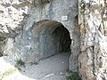
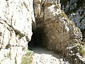
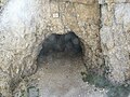
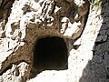
The Strada delle 52 Gallerie ("Road of 52 tunnels"), also known as the 52 Tunnel Road, or Strada della Prima Armata ("Road of the First Army") is a military mule road built during World War I on the Pasubio massif in Veneto, Italy.

Contents

The road winds between Bocchetta Campiglia (1,216 metres [3,990 ft]) [1] and the Porte del Pasubio (1,934 metres [6,345 ft]) [2] crossing the southern slope of the mountain with its spires, deep canyons and sheer rock faces, outside of the range of Austro-Hungarian artillery.

Features

It is 6,555 metres (21,506 ft) long, of which 2,335 metres (7,661 ft) [3] are divided into 52 tunnels excavated from the rock, each tunnel is numbered and characterized by a particular name. The minimum width of 2.20 metres (7.2 ft) was originally intended to allow the transit of two mules with their baggage. [4] The slope of the road reaches 22 percent, with an average of 12 percent. [4] Notable among the many tunnels is the 19th because, in addition to being the longest (320 metres (1,050 ft)), it has a helical layout with 4 hairpin bends, inside a gigantic rock tower. [5]

The Tunnel 20 is carved out of a rock tower, and to overcome the difference in height, twists around itself like a corkscrew. Tunnels 41 through 45 run below the Passo Fontana d'oro (1,875 metres [6,152 ft]). On leaving the 47th, the highest point of the road (2,000 metres [6,562 ft]), there is a magnificent panorama.[ peacock prose ]

The passage of the 15th gallery Passaggio, 15. galleria.jpg
The passage of the 15th gallery
Top of the 20th tunnel (spiral tunnel) Pasubio Tunnel Nr. 20.jpg
Top of the 20th tunnel (spiral tunnel)

Completion

A masterpiece of military engineering and boldness (it was produced by the 33rd Miners Company of the Italian Army with the help of six hundred workers), considering the conditions and the time it was built, and the speed of execution. Work began on February 6, 1917, and was completed in November 1917.

Its implementation was of great strategic importance because it allowed communication and transfer of supplies from the base to the summit area of Mt. Pasubio. Key aspects of the road include year round access, located outside of enemy artillery range and accessible by mule. These were all problems with the similar road of Scarubbi which is only accessible with motorized vehicles, within the range of the Austro-Hungarian guns, and only during the summer.

Mountain biking is strictly prohibited due to a number of fatal accidents.

Order of tunnelName of tunnelLength of tunnelPicture
1Cap. Zappa17 metres Galleria n. 1.JPG
2Gen. D'Havet65 metres Galleria n. 2.JPG
3 Rovereto 14 metres Galleria n. 3.JPG
4 Battisti 31 metres Galleria n. 4.JPG
5 Oberdan 10 metres Galleria n. 5.JPG
6 Trieste 17 metres Galleria n. 6.JPG
7 Gen. Cascino 35 metres Galleria n. 7.JPG
8 Gen. Cantore 23 metres Galleria n. 8.JPG
9 Gen. Zoppi 78 metres Galleria n. 9.JPG
10 Sauro 12 metres Galleria n. 10.JPG
11 Magg. Randaccio 28 metres Galleria n. 11.JPG
12Cap. Motti95 metres Galleria n. 12.JPG
13 Cap. Filzi 27 metres Galleria n. 13.JPG
14Cap. Melchiori61 metres Galleria n. 14.JPG
15 Tortona 45 metres Galleria n. 15.JPG
16 Reggio Calabria 74 metres Galleria n. 16.JPG
17 Bergamo 52 metres Galleria n. 17.JPG
18 Parma 46 metres Galleria n. 18.JPG
19 Re
(Victor Emmanuel III of Italy)
318 metres Galleria n. 19.JPG
20 Gen. Cadorna 86 metres Galleria n. 20.JPG
21 Gen. Porro 20 metres Galleria n. 21.JPG
22 Breganze 8 metres Galleria n. 22.JPG
23 Gen. Capello 18 metres Galleria n. 23.JPG
Order of tunnelName of tunnelLength of tunnelPicture
24 Bologna 16 metres Galleria n. 24.JPG
25 Aquila 11 metres Galleria n. 25.JPG
26 Napoli 24 metres Galleria n. 26.JPG
27Cap. Picone98 metres Galleria n. 27.JPG
28 Genoa 14 metres Galleria n. 28.JPG
29 Spezia 31 metres Galleria n. 29.JPG
30Miss10 metres Galleria n. 30.JPG
31 Gen. Papa 72 metres Galleria n. 31.JPG
32 Palazzolo 48 metres Galleria n. 32.JPG
3333ª minatori57 metres Galleria n. 33.JPG
34Gen. Giustetti132 metres Galleria n. 34.JPG
35 Trani 10 metres Galleria n. 35.JPG
36 Gen. Garibaldi 12 metres Galleria n. 36.JPG
37 Balilla 26 metres Galleria n. 37.JPG
38 Turin 29 metres Galleria n. 38.JPG
39 Mantua 53 metres Galleria n. 39.JPG
40 Trento 10 metres Galleria n. 40.JPG
4126ª minatori24 metres Galleria n. 41.JPG
42 Macerata 19 metres Galleria n. 42.JPG
43 Polesine 55 metres Galleria n. 43.JPG
44Zappatori Liguria22 metres Galleria n. 44.JPG
45Plotone 25ª minatori83 metres Galleria n. 45.JPG
46Piceno65 metres Galleria n. 46.JPG
47Pallanza22 metres Galleria n. 47.JPG
48 Cesena 14 metres Galleria n. 48.JPG
49Soldato italiano19 metres Galleria n. 49.JPG
50 Cav. Vittorio Veneto 27 metres Galleria n. 50.JPG
51Plotone minatori sardo66 metres Galleria n. 51.JPG
52 Sardinia 86 metres Galleria n. 52.JPG

Related Research Articles

<span class="mw-page-title-main">Dolomites</span> Mountain range in the Italian Alps

The Dolomites also known as the Dolomite Mountains, Dolomite Alps or Dolomitic Alps, are a mountain range in northeastern Italy. They form part of the Southern Limestone Alps and extend from the River Adige in the west to the Piave Valley in the east. The northern and southern borders are defined by the Puster Valley and the Sugana Valley. The Dolomites are in the regions of Veneto, Trentino-Alto Adige/Südtirol and Friuli Venezia Giulia, covering an area shared between the provinces of Belluno, Vicenza, Verona, Trentino, South Tyrol, Udine and Pordenone.

<span class="mw-page-title-main">Apennine Mountains</span> Mountain ranges stretching the length of Italy

The Apennines or Apennine Mountains are a mountain range consisting of parallel smaller chains extending c. 1,200 km (750 mi) along the length of peninsular Italy. In the northwest they join with the Ligurian Alps at Altare. In the southwest they end at Reggio di Calabria, the coastal city at the tip of the peninsula. Since 2000 the Environment Ministry of Italy, following the recommendations of the Apennines Park of Europe Project, has been defining the Apennines System to include the mountains of north Sicily, for a total distance of 1,500 kilometres (930 mi). The system forms an arc enclosing the east side of the Ligurian and Tyrrhenian Seas.

<span class="mw-page-title-main">Province of Vicenza</span> Province of Italy

The province of Vicenza is a province in the Veneto region of Italy. Its capital city is Vicenza.

<span class="mw-page-title-main">1st Army (Italy)</span> Italian Army field army, in World War I and II

The 1st Army was a Royal Italian Army field army, in World War I, facing Austro-Hungarian and German forces, and in World War II, fighting on the North African front.

<span class="mw-page-title-main">Posillipo</span> Quarter of Naples, Italy

Posillipo is an affluent residential quarter of Naples, southern Italy, located along the northern coast of the Gulf of Naples.

Posina is a town in the province of Vicenza, Veneto, Italy. It is northeast of SS46. As of 2007 Posina had an estimated population of 657. Posina lies at an elevation of 600 metres (2,000 ft) at the foot of Mount Majo and Mount Gamonda, Mount Pasubio. On the whole dominates the Pasubio which can be accessed through the picturesque Val Caprara, Val Sorapache or arrived at passo Xomo on the Strada degli Scarubbi or the famous Strada delle 52 gallerie great work of military engineering the First World War.

<span class="mw-page-title-main">9th Infantry Division "Pasubio"</span> Military unit

The 9th Infantry Division Pasubio was an infantry division of the Royal Italian Army during World War II. The Pasubio was classified as an auto-transportable division, meaning it had some motorized transport, but not enough to move the entire division at once. The division was formed as an infantry division in 1934, reorganized as auto-transportable division in 1939 and mobilized in August 1940. It was named for the battles on Pasubio during World War I. Its 79th Infantry Regiment and 8th Artillery Regiment were made up of men from Verona, while the ranks of the 80th Regiment were filled with men from Mantua. Its I CC.NN. Battalion "Sabauda" was made up of Blackshirt volunteers from Turin.

<span class="mw-page-title-main">Brenner Railway</span> Major Austro-Italian transport link

The Brenner Railway is a major line connecting the Austrian and Italian railways from Innsbruck to Verona, climbing up the Wipptal, passing over the Brenner Pass, descending down the Eisacktal to Bolzano/Bozen, then further down the Adige Valley to Rovereto/Rofreit, and along the section of the Adige Valley, called in Italian the “Vallagarina”, to Verona. This railway line is part of the Line 1 of Trans-European Transport Networks (TEN-T). It is considered a "fundamental" line by the state railways Ferrovie dello Stato (FS).

<span class="mw-page-title-main">Cima Palon</span> Mountain in Italy

Cima Palon, also called Monte Pasubio, is the highest peak of the Pasubio group of Little Dolomites in Veneto, Italy. It has an elevation of 2,239 metres.

<span class="mw-page-title-main">San Boldo Pass</span> Mountain pass in Veneto, Italy

The San Boldo Pass is a small mountain pass in Veneto between the towns of Trichiana [329 m (1,079 ft)] and Tovena in the Cison di Valmarino region [272 m (892 ft)] over a distance of 17 km (11 mi).

The Slieve Felim Mountains are a mountain range in Munster, Ireland. They cover parts of County Limerick and County Tipperary. Historically, the name "Slieve Felim" meant the whole mountainous area between Murroe, Silvermines, Borrisoleigh and Dundrum, including the Silvermine Mountains and Mauherslieve. However, today the name usually only applies to the southwestern part, made up of Slieve Felim, Cullaun, Knockastanna and Gortnageragh.

<span class="mw-page-title-main">Forte Tre Sassi</span> Historic Austro-Hungarian fortress

Tre Sassi fort is a fortress and museum on the road to the Passo di Valparola, within the comune of Cortina d'Ampezzo in the southern (Dolomitic) Alps of the Veneto region of Northern Italy. Hidden between the Ampezzo valley and the high Val Badia, it was built by Austrians between 1897 and 1901 as a fortification against attack from the Italians on the Falzàrego and Valparo. During World War I it was a favorite target for the Italians, and the fort was destroyed as there was inadequate artillery to defend it.

<span class="mw-page-title-main">Mines on the Italian front (World War I)</span>

The mines on the Italian front during the First World War comprised a series of underground explosive charges of varying sizes, secretly planted between 1916 and 1918 by Austro-Hungarian and Italian tunneling units beneath their enemy's lines along the Italian front in the Dolomite section of the Alps.

<span class="mw-page-title-main">Monte Monega</span> Mountain in Italy

Monte Monega is a 1,882-metre (6,175 ft) mountain of the Ligurian Alps, in Italy.

<span class="mw-page-title-main">Carmo di Brocchi</span> Mountain in Italy

Carmo di Brocchi is a 1,610-metre (5,282 ft) mountain of the Ligurian Alps, in Italy.

<span class="mw-page-title-main">Piani Palentini</span> Plateau in upper Marsica, Abruzzo, Italy

The Piani Palentini is a plateau in upper Marsica, a subregion of Abruzzo, in central Italy.

<span class="mw-page-title-main">Punta Nera</span> Mountain in Italy

The Punta Nera is a mountain of Savoie (France) and of the Province of Turin (Italy). It lies in the Cottian Alps range. It has an elevation of 3,047 metres above sea level.

<span class="mw-page-title-main">8th Field Artillery Regiment "Pasubio"</span> Military unit

The 8th Field Artillery Regiment "Pasubio" is a field artillery regiment of the Italian Army. Today the regiment is based in Persano in Campania and assigned to the Bersaglieri Brigade "Garibaldi". The regiment was formed in 1860 by the Royal Sardinian Army and participated the same year in the Piedmontese invasion of Central and Southern Italy. In 1861 the regiment joined the Royal Italian Army and in 1866 it fought in the Third Italian War of Independence. During World War I the regiment served on the on the Italian front. In 1935 the regiment was assigned to the 9th Infantry Division "Pasubio", which in July 1941 was assigned to the Italian Expeditionary Corps in Russia, which was deployed to the Eastern Front of World War II. In 1942 the division and regiment were destroyed during the Soviet Operation Little Saturn and the survivors of the division were dispersed by invading German forces after the announcement of the Armistice of Cassibile on 8 September 1943.

<span class="mw-page-title-main">White War</span> High-altitude mountain warfare in the Italian front of World War I

The White War is the name given to the fighting in the high-altitude Alpine sector of the Italian front during the First World War, principally in the Dolomites, the Ortles-Cevedale Alps and the Adamello-Presanella Alps. More than two-thirds of this conflict zone lies at an altitude above 2,000m, rising to 3905m at Mount Ortler. In 1917 New York World correspondent E. Alexander Powell wrote: “On no front, not on the sun-scorched plains of Mesopotamia, nor in the frozen Mazurian marshes, nor in the blood-soaked mud of Flanders, does the fighting man lead so arduous an existence as up here on the roof of the world.”

<span class="mw-page-title-main">Dente Italiano</span> Mountain in Trentino, Italy

Dente Italiano is one of the ridges of the Pasubio summit highlands in the Vicentine Alps.

References

Notes

  1. 1 2 (Gattera 2007, p. 27).
  2. 1 2 (Gattera 2007, p. 38).
  3. ( Gattera 2007 , p. 100-109)length of the galleries is obtained by adding the lengths of the individual galleries mentioned in the book
  4. 1 2 ( Gattera 2007 , p. 78) taken from the technical report of Captain Corrado Picone.
  5. ( Gattera 2007 , p. 30).

Cartography

Bibliography