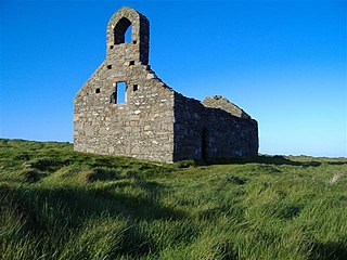
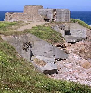
St Michael's Isle, more commonly referred to as Fort Island, is an island in Malew parish in the Isle of Man, noted for its attractive ruins. It covers an area of 5.14 hectares, is about 400 metres long from west to east, and is connected to the Langness Peninsula, near Derbyhaven, by a narrow causeway. The island itself is made of rocky slate and the soil is very acidic. Nevertheless, it has important communities of maritime plants.

The Western Heights of Dover are one of the most impressive fortifications in Britain. They comprise a series of forts, strong points and ditches, designed to protect the country from invasion. They were created in the 18th and 19th centuries to augment the existing defences and protect the key port of Dover from both seaward and landward attack; by the start of the 20th century Dover Western Heights was collectively reputed to be the 'strongest and most elaborate' fortification in the country. The Army finally withdrew from the Heights in 1956–61; they are now a local nature reserve.
Grain Fort is a former artillery fort located just east of the village of Grain, Kent. It was constructed in the 1860s to defend the confluence of the Rivers Medway and Thames during a period of tension with France. The fort's location enabled its guns to support the nearby Grain Tower and Garrison Point Fort at Sheerness on the other side of the Medway. It was repeatedly altered and its guns upgraded at various points in its history, before being decommissioned in 1956 when the UK abolished its coastal defence programme. It was subsequently demolished. The remnants of the fort are still visible and have been incorporated into a coastal park.
Fort Amherst, in Medway, South East England, was constructed in 1756 at the southern end of the Brompton lines of defence to protect the southeastern approaches to Chatham Dockyard and the River Medway against a French invasion. Fort Amherst is now open as a visitor attraction throughout the year with tours provided through the tunnel complex

Pendennis Castle is an artillery fort constructed by Henry VIII near Falmouth, Cornwall, England between 1540 and 1542. It formed part of the King's Device programme to protect against invasion from France and the Holy Roman Empire, and defended the Carrick Roads waterway at the mouth of the River Fal. The original, circular keep and gun platform was expanded at the end of the century to cope with the increasing Spanish threat, with a ring of extensive stone ramparts and bastions built around the older castle. Pendennis saw service during the English Civil War, when it was held by the Royalists, and was only taken by Parliament after a long siege in 1646. It survived the interregnum and Charles II renovated the fortress after his restoration to the throne in 1660.
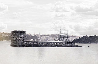
Fort Denison, part of the Sydney Harbour National Park, is a protected national park that is a heritage-listed former penal site and defensive facility occupying a small island located north-east of the Royal Botanic Garden and approximately 1 kilometre (0.62 mi) east of the Opera House in Sydney Harbour, New South Wales, Australia. The island is also known as Mattewanye or Muddawahnyuh in the Eora language, and as Pinchgut Island.

Illiam Dhone or Illiam Dhône, also known as William Christian, was a Manx politician and depending on viewpoint, patriot, rebel or traitor. He was a son of Ewan Christian, a deemster. In Manx, Illiam Dhone literally translates to Brown William—an epithet he received due to his dark hair—and in English he was called Brown-haired William. Dhone was a significant figure in the Isle of Man during the English Civil War and the Manx Rebellion of 1651. He was executed for high treason in 1663. In the centuries after his death he has become a "martyr and folk-hero, a symbol of the Island's cherished freedoms and traditional rights".

Isle of Man Airport is the main civilian airport on the Isle of Man. It is located in the south of the island at Ronaldsway near Castletown, 6 nautical miles southwest of Douglas, the island's capital. Along with the Isle of Man Sea Terminal, it is one of the two main gateways to the island. The airport has scheduled services to the United Kingdom and the Republic of Ireland.

Derbyhaven is a hamlet near Castletown in the southern parish of Malew, Isle of Man. It is located on the isthmus connecting Langness Peninsula to the rest of the island, on the bay of the same name, and also on Castletown Bay on the other side of the isthmus.

Malew is one of the seventeen parishes of the Isle of Man.
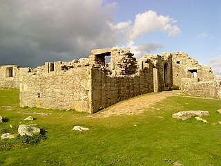
King Charles's Castle is a ruined artillery fort overlooking New Grimsby harbour on the island of Tresco in the Isles of Scilly. Built between 1548 and 1551 to protect the islands from French attack, it would have held a battery of guns and an accompanying garrison, designed to prevent enemy vessels from entering the harbour. The castle is polygonal in design, constructed from granite stone, with the gun battery at the front, and a dining room, kitchen and living accommodation at the rear. An additional defensive earthwork was constructed around it during the 17th century. The design of the castle is unusual for the period, and is only seen elsewhere in blockhouses along the River Thames.

The Victoria Lines, originally known as the North West Front, are a line of fortifications that spans 12 kilometres along the width of Malta, dividing the north of the island from the more heavily populated south.

The Bradleys Head Fortification Complex is a heritage-listed former mast and defensive battery and military fortification and now war memorial and recreational area located at Bradleys Head Road within the Sydney Harbour National Park in the Sydney suburb of Mosman, New South Wales, Australia. It was designed by Government engineers and built from 1840 to 1934. It is also known as Bradleys Head Forts and HMAS Sydney 1 Mast and Associated Memorials. The property is owned by the NSW Office of Environment and Heritage, an agency of the Government of New South Wales. It was added to the New South Wales State Heritage Register on 30 August 2010.

The Stokes Bay Lines were part of the great Victorian fortification of Portsmouth Harbour under Lord Palmerston. In 1857 Major Jervois had proposed a complex system of moats (ditches), ramparts and batteries to close off the gap between the new fort at Fort Gomer, and the earlier fort at Fort Gilkicker, and Fort Monckton. This defensive moat was to become the ‘Stokes Bay Lines’.

The Old Blockhouse, also known as the Dover Fort, is a 16th-century fortification on the island of Tresco in the Isles of Scilly. It was built between 1548 and 1551 by the government of Edward VI to protect the islands against French attack.
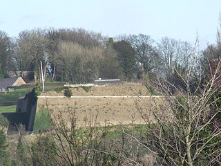
Grain Wing Battery is a former gun battery located just east of the village of Grain, Kent at the confluence of the Rivers Thames and Medway. It supported two existing and adjacent artillery batteries at Grain Fort and Dummy Battery, overlapping its arc of fire with Grain Tower just offshore and with Garrison Point Fort on the Isle of Sheppey across the other side of the Medway. The battery consisted of an earthwork with several gun emplacements. It was only in use as a battery for a few years after its completion in 1895, though its interior continued to be occupied by Army buildings. It was abandoned in 1956 and its remains were demolished and infilled a few years later. The site is now part of a coastal park owned by the local council.
The island of Guernsey has been fortified for several thousand years, the number of defence locations and complexity of the defence increasing with time, manpower and the improvements in weapons and tactics.
Ewan Christian was a Manx politician and landowner on the Isle of Man. He held the position of deemster for 51 years from 1605 until his death. He also held the position of Deputy-Governor of the Isle of Man 1634 to 1637. He was the father of controversial Manx political revolutionary and folk-hero Illiam Dhone.
The Manx Rebellion of 1651 was an uprising against the ruler of the Isle of Man during the English Civil War. It was led by William Christian, better known by the epithet Illiam Dhone, due to his dark hair. The Rebellion was mainly in response to agrarian and land ownership reforms enacted by Lord of Mann James Stanley, 7th Earl of Derby, and the increased burden on the Manx people during the English Civil War. It was a bloodless coup with English Parliamentary forces taking control of the island. The Rebellion temporarily ended control of the Isle of Man by the Stanley family until the Restoration when King Charles II returned from exile in Europe.


