Susitna North is a census-designated place (CDP) in the Matanuska-Susitna Borough in the U.S. state of Alaska. It is part of the Anchorage, Alaska Metropolitan Statistical Area. The population was 1,260 at the 2010 census, up from 956 in 2000. The CDP was formerly named Y, for the intersection of the George Parks Highway and the Talkeetna Spur Road. In the immediate vicinity of this intersection is a community center of sorts, containing a health clinic, law enforcement, Susitna Valley High School and retail services for highway travelers such as gasoline and food.

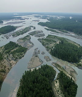
The Susitna River is a 313-mile (504 km) long river in the Southcentral Alaska. It is the 15th largest river in the United States, ranked by average discharge volume at its mouth. The river stretches from the Susitna Glacier to Cook Inlet's Knik Arm.

The Yentna River is a river in South Central Alaska, formed by its East Fork and West Fork at 62°16′50″N151°46′26″W, flows South-East to Susitna River, 30 miles (48 km) North-West of Anchorage, Alaska; Cook Inlet Low.

Tustumena Lake is a lake on the west side of the Kenai Peninsula in southcentral Alaska, within Kenai National Wildlife Refuge and near the town of Kasilof. Access is only via the Kasilof River, there are no roads that lead directly to the lake.

Birch Creek is a 150-mile (240 km) tributary of the Yukon River in the U.S. state of Alaska. Beginning at the confluence of Ptarmigan and Eagle creeks near Porcupine Dome, it flows southwest, then south under the Steese Highway and into the Steese National Conservation Area. It then turns east, then north, again passing under the Steese Highway and entering the Yukon Flats National Wildlife Refuge. Turning northwest, it ends where it splits into two distributaries, Lower Mouth Birch Creek and Upper Mouth Birch Creek, near Birch Creek, Alaska. The distributaries flow into the Yukon River at separate locations downstream of Fort Yukon.

Denali State Park is a 325,240-acre (131,620 ha) state park in the U.S. state of Alaska. It is located in the Matanuska-Susitna Borough adjacent to the east side of Denali National Park and Preserve, along the Parks Highway.

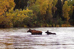
Mount Susitna is a 4,396-foot (1,340 m) mountain in the U.S. state of Alaska. It is located on the west bank of the lower Susitna River, about 33 miles (53 km) northwest of Anchorage, Alaska. The mountain is a prominent landmark in the Anchorage area and can be seen across the Knik Arm of the Cook Inlet from most of the city, especially at higher elevations.

The Kantishna River is a 108-mile (174 km) tributary of the Tanana River in the U.S. state of Alaska. Formed by the confluence of the McKinley River with Birch Creek in Denali National Park and Preserve, it drains part of the north slope of the Alaska Range including the Denali massif. The direction of flow is generally north-northeast. The Toklat River is a major tributary.
Dinglishna Hill is a hill located East of Mount Susitna, in the Matanuska-Susitna Valley of South Central Alaska.

Alexander is an unincorporated community in Matanuska-Susitna Borough, Alaska, United States. An Alaska Native community with an Alaska Native Village Corporation, it lies on the Susitna River delta, near the mouth of Alexander Creek, and 27 miles (43 km) northwest of Anchorage, Alaska Cook Inlet Low. It is located within the boundaries of Susitna CDP.
Alexander Creek, also known as Taguntna Creek, is a 35 miles (56 km) long stream from Alexander Lake which merges with the big Susitna River near the village of Alexander Creek, Alaska also known as Alexander, Alaska, an Alaska Native and Alaska Bush community, in Matanuska-Susitna Borough, Alaska.
Alexander Lake is a lake in South Central Alaska, located at head of Alexander Creek, 46 miles (74 km) North of Tyonek, Alaska on Cook Inlet Low.

Kantishna is an unincorporated community in Denali Borough, Alaska, United States, within Denali National Park and Preserve. Founded as a gold mining camp in 1905, it endured longer than similar communities in the area, having been constructed nearest to the source of the gold. It lies in the Kantishna Hills at the junction of Eureka Creek and Moose Creek, 3 mi (5 km) northwest of Wonder Lake, and near the mouth of the Kantishna River. Although the community was once also called "Eureka", the Board on Geographic Names officially ruled in favor of "Kantishna" in 1944, the name given to the post office that was built at the site in 1905. Its elevation is 1,696 feet (517 m).

Trail Creek also known as Trail River is a stream in the Chugach Mountains near Moose Pass, Alaska. It flows through the Trail Lakes and ends at Kenai Lake. There is a USFS campground near where the river empties into Kenai Lake, the river can be fished in the late summer for various species of trout.
There are three glaciers named West Fork Glacier in Alaska, two of which are in the Alaska Range. The first West Fork Glacier is a glacier in Denali National Park and Preserve in the U.S. state of Alaska. The glacier originates at Anderson Pass, extending to the east and forming the source of the West Fork of the Chulitna River. Traleika Glacier was named in 1945 by Bradford Washburn, attributing the name to a Susitna name meaning "great one" or "high one." GNIS ID 1411870
Queer Creek is a stream in Matanuska-Susitna Borough, Alaska, in the United States. It is 4 miles (6.4 km) in length.
The Chulitna River is a 110 km long right tributary of the Susitna River in southern part of interior Alaska. Three forks converge to form the river, which itself flows into the Susitna River near Talkeetna.