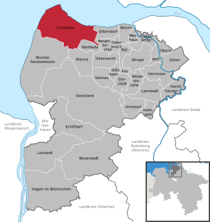
Cuxhaven is a district (Landkreis) in Lower Saxony, Germany. It is bounded by the districts of Stade, Rotenburg, Osterholz and Wesermarsch, the city of Bremerhaven and the North Sea.
Stade is a district (Landkreis) in Lower Saxony, Germany. It has its seat in Stade and is part of the Hamburg Metropolitan Region.
Cuxhaven is an independent town and seat of the Cuxhaven district, in Lower Saxony, Germany. The town includes the northernmost point of Lower Saxony. It is situated on the shore of the North Sea at the mouth of the Elbe River. Cuxhaven has a footprint of 14 kilometres (east–west) by 7 km (4 mi) (north–south). Its town quarters Duhnen, Döse and Sahlenburg are especially popular vacation spots on the North Sea and home to about 52,000 residents.

Neuwerk (help·info) is a 3 km2 (1.2 sq mi) tidal island in the Wadden Sea on the German North Sea coast, with a population of 32. Neuwerk is located 13 km (8 mi) northwest of Cuxhaven, between the Weser and Elbe estuaries. The distance to the centre of Hamburg is about 120 km (70 mi). Archaic English names for the island are New Werk and Newark.

Sahlenburg is a borough of the city Cuxhaven near the mouth of the river Elbe in Lower Saxony, Germany. The Sahlenburg beach is popular with tourists. In addition to swimming in the sea when the tide permits, there are also walks into the Duhner and the Werner forests.

Oste is a river in northern Lower Saxony, Germany with a length of 149 km (93 mi). It is a left tributary of the Elbe.

Otterndorf is a town on the coast of the North Sea in the federal state of Lower Saxony, Germany, and is part of the collective municipality (Samtgemeinde) of Land Hadeln. The town, located in the administrative district (Landkreis) of Cuxhaven, is at the mouth of the river Medem, part of the Elbe delta. The old town centre (Altstadt) features a number of half-timbered houses.
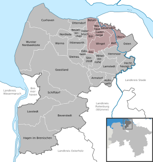
Am Dobrock is a former Samtgemeinde in the district of Cuxhaven, in Lower Saxony, Germany. It is situated near the confluence of the rivers Oste and Elbe, approx. 25 km east of Cuxhaven, and 15 km south of Brunsbüttel. Its seat is in the village Cadenberge. On 1 November 2016 it was merged into the Samtgemeinde Land Hadeln.

Neuhaus an der Oste is a municipality in the district of Cuxhaven, in Lower Saxony, Germany.
The Stade Region emerged in 1823 by an administrative reorganisation of the dominions of the Kingdom of Hanover, a sovereign state, whose then territory is almost completely part of today's German federal state of Lower Saxony. Until 1837 the Kingdom of Hanover was ruled in personal union by the Kings of the United Kingdom of Great Britain and Ireland.
The Stade Geest is a natural region of low, sandy heath (geest) in the North German Plain.

The region between the Elbe and Weser rivers forms the Elbe–Weser triangle, also rendered Elbe-Weser Triangle, in northern Germany. It is also colloquially referred to as the Nasses Dreieck or "wet triangle".

The Wingst is a ridge, up to 74 metres high, in northern Lower Saxony, Germany.

The Silberberg is a low hill, 74 metres high, in the Wingst ridge in the district of Cuxhaven in the north German state of Lower Saxony.
Land Hadeln is a historic landscape and former administrative district in Northern Germany with its seat in Otterndorf on the Lower Elbe, the lower reaches of the River Elbe, in the Elbe-Weser Triangle between the estuaries of the Elbe and Weser.
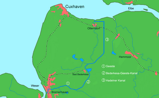
The Elbe–Weser waterway or Elbe–Weser shipping channel is a short-cut between the rivers Elbe and Weser in North Germany which is part-canal and part-river. It has a length of 54.7 kilometres (34.0 mi) and is designed for smaller coastal vessels. It includes some 60 kilometres (37 mi) of canal dykes and 45 kilometres (28 mi) of canal paths. The channel starts in Otterndorf with the Hadeln Canal, then becomes the Bederkesa-Geeste Canal from the town of Bad Bederkesa to the River Geeste, the final leg of the shipping channel, which flows into the Weser at Bremerhaven. It is owned by the state of Lower Saxony, maintained by the NLWKN from its Stade office. Today they just look after maintenance of the drainage system, because the economic element of the canal – commercial shipping which was particularly thriving in the late 1960s – declined increasingly from 1973 onwards and today hardly exists at all. Nevertheless the waterway is still used by smaller yachts as a short cut between Elbe and Weser.
The Ruhn Hills are a terminal moraine ridge up to 176.8 m above sea level (NHN), which lies on either side of the border between the German states of Brandenburg and Mecklenburg-Vorpommern near Parchim. After the Helpt Hills they are the second highest points in the latter federal state.

The Kugelbake is a historic aid to navigation in the city of Cuxhaven, Germany, at the northernmost point of Lower Saxony, where the River Elbe flows into the North Sea. In the Low German dialect of the Middle Ages, the term bake referred to all navigational aids – including lighthouses. About 30 meters (100 feet) high and built of wood, the Kugelbake is the principal landmark of Cuxhaven; since 1913, it has been depicted on the city's coat of arms. Large wooden structures guiding mariners have stood on this spot for over 300 years.
The Wesermünde Geest is the collective name for several geest ridges in the west of Cuxhaven district and Bremen's North Borough in northern Germany. The ridges are separated from one another by wetlands. These terminal moraines were formed during the Saale glaciation, are up to between 10 to 70 m above sea level (NN), and are covered by scattered woods and farmland. The wetland areas, between 0 to 5 m above sea level, are predominantly used for grazing.

The Kellerberg is a hill, 448.8 m above sea level (NHN), and the highest point of the Eifel part of the Meulenwald and of the collective municipality of Wittlich-Land. It rises near Dierscheid in the county of Bernkastel-Wittlich in the German state of Rhineland-Palatinate. At the top is the Kellerberg Observation Tower.

