
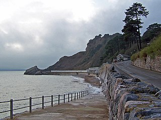
Devon United Mine (grid reference SX521795 ) is a 1.0 hectare geological Site of Special Scientific Interest in Devon, England, notified in 1987.
Devon United Mine (grid reference SX521795 ) is a 1.0 hectare geological Site of Special Scientific Interest in Devon, England, notified in 1987.
Coordinates: 50°35′47″N4°05′28″W / 50.59644°N 4.09106°W
| | This article about a Site of Special Scientific Interest in England is a stub. You can help Wikipedia by expanding it. |
| | This Devon location article is a stub. You can help Wikipedia by expanding it. |

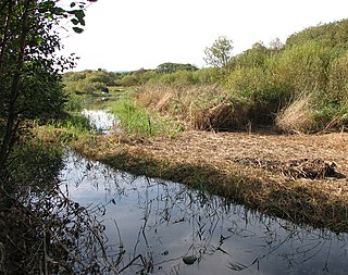
The Walkham is a river whose source is on Dartmoor, Devon, England. It rises in the wide gap between Roos Tor and Great Mis Tor and flows almost due south for approximately 3 miles (4.8 km) leaving the tors and thus National Park behind then south-west for 1 mile (1.6 km) past Woodtown. The river then reaches a village, Horrabridge, with a small compact network of streets mainly on the south or left bank. It receives most of its tributaries which are unnamed headwaters along its south-flowing inception, draining the near side of two series of six tors (peaks) to the west ending in Pew Tor at 320 metres and likewise to the east ending in Leeden Tor at 389 metres. In absolute distance, 2 miles (3.2 km) west of the village and the same south of the small well-preserved town of Tavistock by a footbridge on the West Devon Way the Walkham joins the Tavy which discharges into the Tamar Estuary north of the Plymouth conurbation after a fast descent around wide hillsides, a few miles south.

East Portlemouth is a small Devon village situated at the southern end of the Kingsbridge Estuary, on the south Devon Coast. The population of this parish taken at the 2011 census was 162. The village is sited on a hill giving views to the north to Kingsbridge and on a clear day as far as Dartmoor. There is a small ferry that runs to Salcombe in the opposite side of the estuary, and a beach that is popular with holidaymakers.

The Kingsbridge Estuary in the South Hams area of Devon, England runs from Kingsbridge in the north to its mouth at the English Channel near Salcombe and lies between Bolt Head and Sharpitor to the west and Portlemouth Down to the east. The estuary is some 8.6 kilometres (5.3 mi) in length, with numerous side channels. Several of its creeks have independent names, including Blanksmill, Frogmore, Southpool, Batson and Bowcombe Creek.

Slapton is a village and civil parish in the South Hams district of Devon, England. It is located near the A379 road between Kingsbridge and Dartmouth, and lies within the South Devon Area of Outstanding Natural Beauty (AONB). The nearby beach is Slapton Sands; despite its name, it is not a sandy beach but a shingle one.

Atherington is a village and civil parish in the North Devon district of Devon, England, about 8 miles south of Barnstaple. According to the 2001 census the parish had a population of 391.

The River Creedy is a small river in Devon, England. It gives its name to the local town or ton of Crediton, which is on its west bank, and to several local historic estates, namely Creedy Hilion, Creedy Peitevin and Creedy Park, in the parish of Sandford, also to the Benefice of North Creedy. Just below the town, the river merges with the River Yeo and it ends where it meets the River Exe at Cowley Bridge. The river is overlooked by Fordy Wood Copse, a 0.64 hectares woodland owned and managed by the Woodland Trust.

Slapton Ley is a lake on the south coast of Devon, England, separated from Start Bay by a shingle beach, known as Slapton Sands.
Meadfoot Sea Road is a 6.1 hectare geological Site of Special Scientific Interest in Devon, England, notified in 1987 for its Devonian geology.

Lopwell is a site of natural beauty situated at the normal tidal limit of the River Tavy, 3 miles from north Plymouth and 7 miles from Tavistock, Devon, England.
The Dawlish Warren National Nature Reserve is a national nature reserve near the village of Dawlish Warren in south Devon, England. It is part of the Exe Estuary Special Protection Area, and sits on a sand spit which runs across the mouth of the estuary. It is also a Site of Special Scientific Interest and part of it is a local nature reserve.

Woolfardisworthy is a village and civil parish in Mid Devon. It is situated about 9 km north of Crediton.
Hillsea Point Rock is an area of the English Channel located 0.5 nm south-east of Hillsea Point, Devon. It consists of seven or eight pinnacles ranging in depth between 25 metres on the sea bed and 2 metres at the surface
Meddon Green is a 1.7 hectare (ha) Local Nature Reserve, located at Meddon, near Bideford in Devon. It consists of culm grassland surrounded by hazel coppice. The reserve is owned by Hartland Parish Council and was declared in 2007. The site contains many typical culm grassland plants including Southern Marsh Orchid and Greater Bird's-foot Trefoil.

Kelly is a small village in west Devon, England.
Chudleigh Cavern is a limestone cave outside the town of Chudleigh in Devon, England. The cave is deep and contains stalactites. A small part is open to the public as a show cave. The rest is open only to experienced cavers.

The River Ottery is a small river in northeast Cornwall, United Kingdom. The river is about twenty miles (32 km) long from its source southeast of Otterham to its confluence with the River Tamar at Nether Bridge, two miles (3.2 km) northeast of Launceston.

Meeth is a small village roughly 13.5 km (8.4 mi) north-northwest of Okehampton and 40.7 km (25.3 mi) west-northwest of Exeter. It lies to the west of the River Torridge. In the past, ball clay mines were a major source of employment in the village, lying just to the west, however these closed in 2004. Their site is now a nature reserve owned by the Devon Wildlife Trust, called Meeth Quarry. The Trust's Ash Moor reserve is also located close to the village.
Meddon Moor is a Site of Special Scientific Interest (SSSI) in Cornwall, England. The moor is located in the very north-eastern corner of Cornwall, on the border with Devon, within the civil parish of Morwenstow. The Devon village of Meddon lies 500 metres (1,600 ft) to the north-east of the moor.

Hollacombe is a village and small civil parish in the local government district of Torridge, Devon, England. It lies about 3 miles south east of the town of Holsworthy and is surrounded clockwise from the north by the parishes of Cookbury, Ashwater, and Holsworthy Hamlets. In 2001 its population was 59, compared to 69 in 1901.

Germansweek is a village and civil parish in the West Devon district, to the west of Okehampton in the county of Devon, England.