
The Kingdom of Bhutan is a sovereign nation, located towards the eastern extreme of the Himalayas mountain range. It is fairly evenly sandwiched between the sovereign territory of two nations: first, the People's Republic of China on the north and northwest. There are approximately 477 kilometres of border with that nation's Tibet Autonomous Region. The second nation is the Republic of India on the south, southwest, and east; there are approximately 659 kilometres with the states of Arunachal Pradesh, Assam, West Bengal, and Sikkim, in clockwise order from the kingdom. Bhutan's total borders amount to 1,139 kilometres. The Republic of Nepal to the west, the India to the south, and the Union of Myanmar to the southeast are other close neighbours; the former two are separated by only very small stretches of Indian territory.

Trashigang District is Bhutan's easternmost dzongkhag (district).

Samdrup Jongkhar District is one of the 20 dzongkhags (districts) comprising Bhutan. The dominant languages of the district are Tshangla (Sharchopkha) in the north and west, and Nepali in the east. It covers a total area of 1878 sq km. Samdrup dzongkhag comprises two dungkhags: Jhomotsangkha and Samdrupchhoeling, and 11 gewogs.

Trashiyangtse District is one of the twenty dzongkhags (districts) comprising Bhutan. It was created in 1992 when Trashiyangtse district was split off from Trashigang District. Trashiyangtse covers an area of 1,437.9 square kilometres (555.2 sq mi). At an elevation of 1750–1880 m, Trashi yangtse dzongkhag is rich of culture filled with sacred places blessed by Guru Rimpoche and dwelled by Yangtseps, Tshanglas, Bramis from Tawang, Khengpas from Zhemgang and Kurtoeps from Lhuentse.

Bhutan, officially known as the Kingdom of Bhutan, is a landlocked country in the Eastern Himalayas, located in Southern Asia between China and India. It is a mountainous country. Bhutan is known as "Druk Yul," or "Land of the Thunder Dragon". Nepal and Bangladesh are located near Bhutan but do not share a land border. The country has a population of over 788,615 and territory of 38,394 square kilometres (14,824 sq mi) and ranks 133rd in terms of land area and 160th in population. Bhutan is a constitutional monarchy with Vajrayana Buddhism as the state religion.

The Duar War was a war fought between British India and Bhutan in 1864–1865. It has been the only military conflict between the two states since 1774.

Sankosh is a river that rises in northern Bhutan and empties into the Brahmaputra in the state of Assam in India. In Bhutan, it is known as the Puna Tsang Chu below the confluences of several tributaries near the town of Wangdue Phodrang.

Torsa River rises from the Chumbi Valley in Tibet, China, where it is known as Machu. It flows into Bhutan, where it is known as the Amo Chu. Finally it flows in West Bengal in India and Bangladesh, where it is called Torsa. It has a length of 358 kilometres (222 mi) before entering India, of which 113 kilometres (70 mi) are in Tibet and 145 kilometres (90 mi) in Bhutan. It is also known as: Chumbi, Am-Chu, Jaldhaka.
Samdrupcholing, formerly known as Bhangtar, is a rural town, Yenlag Thromde, in the southeast of Bhutan. It is located in Samdrup Jongkhar District, close to the border with India.
The Kingdom of Sikkim, officially Dremoshong until the 1800s, was a hereditary monarchy in the Eastern Himalayas which existed from 1642 to 16 May 1975. It was ruled by Chogyals of the Namgyal dynasty.

Baksa district is an administrative district in the Bodoland Territorial Region of Assam, one of the North-Eastern states of India. The administrative headquarters is at Mushalpur. Manas National Park is a part of this district.
Jongkhar is a small town in southern Bhutan near the border with India.

The Kuri Chhu, also known as the Lhozhag Xung Qu or Norbu Lag Qu, is a major river of eastern Bhutan, that has formed a scenic valley with high peaks and steep hills. Kuri Chhu is a tributary of the Manas River system, which is the largest river of Bhutan and a major tributary of the Brahmaputra River that drains most of eastern Bhutan.

Khoma Gewog is a gewog of Lhuntse District, Bhutan.
Phongmed Gewog is a gewog of Trashigang District, in the East of Bhutan.

This is a list of the extreme points of Bhutan.
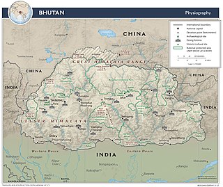
The Bhutan–India border is the open international border separating Bhutan and India. The border is 699 km long, and adjoins the Indian states of Assam, Arunachal Pradesh, West Bengal, and Sikkim.
Lumla is the headquarters of its eponymous subdivision, tehsil and Legislative Assembly in the Tawang district of Indian state of Arunachal Pradesh. The current MLA (August-2016) of this constituency is Jambey Tashi. Lumla borders Bhutan in the west, Tibet in the north.
Hat Basantapur is a village in the Arambagh CD block in the Arambagh subdivision of Hooghly district in the Indian state of West Bengal.
