
The Tomb of Shah Jamal is the tomb of Sufi Saint Baba Shah Jamal. It is located in Lahore, Punjab, Pakistan. It can be located opposite Forman Christian (FC) College, near Muslim Town. There is a masjid built around the tomb which incorporates a graveyard.

Sagar is a city, municipal corporation and administrative headquarter in Sagar district of the state of Madhya Pradesh in central India. It's Madhya Pradesh's 6th largest city of by Population. The city is situated on a spur of the Vindhya Range, 1,758 feet (536 m) above sea-level around 172 kilometres (107 mi) northeast of the state capital, Bhopal.

Farīduddīn Masūd Ganjshakar, commonly known as Bābā Farīd or Sheikh Farīd, was a 13th-century Punjabi Muslim mystic, poet and preacher. Revered by Muslims, Hindus and Sikhs alike, he remains one of the most revered Muslim mystics of South Asia during the Islamic Golden Age.
Bayana is a historical town and the headquarters of Bayana tehsil in Bharatpur district of Rajasthan in India. Hindaun City is nearest city of Bayana - 33 km. Bayana is also known as the city of 'Vansasur'. It was the site of famous Important Battle of Bayana in 1527 between Rajput ruler Rana Sanga ruler of Mewar and Mughal emperor Babur.

Sagar district is a district of Madhya Pradesh state in central India. The town of Sagar serves as its administrative center. Sagar district is called the heart district of India. Tropic of Cancer (23°3') passes through Rangir Tiraha on NH26 present NH44 in Sagar district.

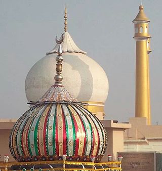
Pakpattan, often referred to as Pākpattan Sharīf, is an ancient, historic city in the Pakistani province of Punjab, serving as the headquarters of the eponymous Pakpattan district. It is among the oldest cities in Asia and ranks as the 48th largest city in Pakistan by population, according to the 2017 census. Pakpattan is the seat of the Sufi Chisti order in Pakistan, and a major pilgrimage destination on account of the Shrine of Baba Farid, a renowned Punjabi poet and Sufi saint. The annual urs fair in his honour draws an estimated 2 million visitors to the town.
Bilgram is a town and a nagar palika parishad in Hardoi district in the state of Uttar Pradesh, India. It is located 16 miles (26 km) south of the city of Hardoi, on an elevated bluff that once formed the eastern bank of the Ganges. Important industries in Bilgram include ceramics and embroidery.
Meham, also spelled Maham, is a small city in Rohtak district of the Indian state of Haryana. It is one of the two sub-divisions in Rohtak district. As a tehsil, it is further divided into two community development blocks, Maham and Lakhan-Majra.
Sadhaura is a town, near Yamunanagar city with Municipal Committee in Yamunanagar district in the Indian state of Haryana. The city of Yamunanagar, it is of great historic significance. Sadhaura is very old town many historical temples/Dargah are there like Manokamna Temple, Laxmi narayan Temple, Roza Peer Dargah are some famous places in Sadhaura.

Vijaygarh Fort is a ruined fort located 30 km from Robertsganj in south east direction in Mau Kalan village in Chatra block near Dhandhraul Dam on Chatra-Siltham road, in Robertsganj in the Sonbhadra district, Uttar Pradesh India.

Tourism in Marathwada refers to tourism in the Marathwada region of Maharashtra state in India. Aurangabad is a regional headquarters in Marathwada, and the tourism capital of Maharashtra state. Out of the four UNESCO World Heritage Sites in Maharashtra, two are in the Marathwada region. There are also 110 monuments in Marathwada which are protected by Government of Maharashtra and recognized by Archaeological Survey of India.
Tourism in Haryana relates to tourism in the state of Haryana, India. There are 22 tourism hubs created by Haryana Tourism Corporation (HTC), which are located in Ambala, Bhiwani, Faridabad, Fatehabad, Gurgaon, Hisar, Jhajjar, Jind, Kaithal, Karnal, Kaimla, Kurukshetra, Panchkula, Sirsa, Sonipat, Panipat, Rewari, Rohtak, Yamunanagar, Palwal and Mahendergarh.

Muni Tarun Sagar was an Indian Digambara monk. His lectures are termed Kadve Pravachan because they can be candidly critical of common practices and views. His lectures have been compiled and published in book series also titled Kadve Pravachan. Excerpts from his discourses are often published by newspapers. Unlike most other Digambar Jain monks, his audience often included a majority of non-Jains. His discourses often addressed family or society issues.
The Shrine of Baba Farid is a 13th-century Sufi shrine located in Pakpattan, Punjab, Pakistan dedicated to the Punjabi Sufi mystic and poet Baba Farid. The shrine is one of the most important in Pakistan, and was among the first Islamic holy sites in South Asia – providing the region's Muslims a local focus for devotion. The shrine is also revered by Sikhs, who include Baba Farid's poetry into the Guru Granth Sahib – regarded by Sikhs to be the eternal Guru.

Guru Ram Rai Darbar Sahib is a Ramraiya Sikh place of worship in Dehradun, India, dedicated to Baba Ram Rai, eldest son of Guru Har Rai, the seventh of the ten Sikh Gurus. Baba Ram Rai settled here with his followers in the mid-17th century, after he was banished by Guru Har Rai for mistranslating scripture in front of the Mughal emperor Aurangzeb, so as to not cause offence. It is believed the city, Dehradun, gets its name from the religious camp established by him: a "dera", or camp, in the "doon" valley.

Dargah Bade Purush Baba Dikauli Sharif or Bade Purush Dargah is a dargah (shrine) located at Dikauli village in Shravasti district of Uttar Pradesh, India near Bahraich. It is the dargah of Hazrat Ameer Nasrullah or Nasrullah Shah or Hazrat Saiyyad Nasrullah Gaazi or Mir Nasrullah, who is famously known as Bade Purush or Bade Purukh and Budhwa Baba. Bade Purush is revered by both the Muslims and Hindus.

Garhpehra is a village in Sagar District in the Indian state of Madhya Pradesh. There is a fort called garhpehra fort.

Dargah Hazrat Sheikh Musa is a dargah (mausoleum) of a Sufi saint of Chishti Order, Hazrat Sheikh Musa, who moved to Mewat from Delhi to preach Islam. It’s situated in Palla Village of Nuh district in Haryana, India and recognised as a State Protected Monument by the Government of Haryana.

Harsiddhi Devi Mandir is a Hindu temple dedicated to Devi Harsiddhi in the Sagar District of Madhya Pradesh, India.


