Dhanwada ధన్వాడ | |
---|---|
village | |
Coordinates: 16°39′00″N77°40′00″E / 16.6500°N 77.6667°E Coordinates: 16°39′00″N77°40′00″E / 16.6500°N 77.6667°E | |
Country | |
State | Telangana |
District | Mahaboob Nagar |
Elevation | 419 m (1,375 ft) |
Languages | |
• Official | Telugu |
Time zone | UTC+5:30 (IST) |
Vehicle registration | TS06 |
Climate | hot (Köppen) |
Website | www.infomahabubnagar.com |
Dhanvada or Dhanwada is a Mandal in Mahbubnagar district, Telangana. This mandal is part in Narayanapet Assembly Constituency and Mahabubnagar Loksabha Constituency. [1]
A tehsil is an administrative division in some countries of South Asia. It is an area of land with a city or town that serves as its administrative centre, with possible additional towns, and usually a number of villages. The terms in India have replaced earlier geographical terms, such as pargana, pergunnah and thannah, used under Delhi Sultanate and the British Raj.
Mahabubnagar district is a district in the Indian state of Telangana. Mahabubnagar is the district headquarters which is popularly known as palamoor..The district shares boundaries with Vikarabad, Rangareddy, Nagarkurnool, Wanaparthy and Jogulamba Gadwal districts and with Karnataka state.This district was formed during the period of the 6th Nizam of Hyderabad State - Nawab Mir Mahbub Ali Khan and hence named after him.
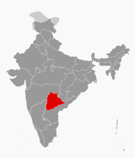
Telangana is a state in India situated on the centre-south stretch of the Indian peninsula on the high Deccan Plateau. It is the twelfth largest state and the twelfth-most populated state in India with a geographical area of 112,077 km2 (43,273 sq mi) and 35,193,978 residents as per 2011 census. On 2 June 2014, the area was separated from the northwestern part of Andhra Pradesh as the newly formed 29th state with Hyderabad as its historic permanent capital. Its other major cities include Warangal, Nizamabad, Khammam and Karimnagar. Telangana is bordered by the states of Maharashtra to the north, Chhattisgarh to the east, Karnataka to the west, and Andhra Pradesh to the east and south. The terrain of Telangana region consists mostly of hills, mountain ranges, and thick dense forests distribution of 27,292 sq. km. As of 2019, the state of Telangana is divided into 33 districts.
Dhanwada is located at 16°39′00″N77°40′00″E / 16.6500°N 77.6667°E . [2] It has an average elevation of 419 metres (1,375 ft).
Andhra Bank is a medium-sized public sector bank (PSB) of India, with a network of 2900 branches, 4 extension counters, 38 satellite offices and 3636 automated teller machines (ATMs) as of 31 sep 2018. During 2011–12, the bank entered the states of Tripura and Himachal Pradesh. The bank now operates in 25 states and three Union Territories. Andhra Bank has its headquarters in Hyderabad, Telangana, India.
The villages in Dhanwada mandal include: [3]
Kalyandurg is a town in Anantapur district of the Indian state of Andhra Pradesh. It is the headquarters for Kalyandurg mandal and Kalyandurg revenue division. The discovery of diamond-bearing Kimberlites in Kalyandurg area, is one of the clusters that has been discovered.
Amalapuram is a town in East Godavari district of the Indian state of Andhra Pradesh. It is the mandal and divisional headquarters of Amalapuram mandal and Amalapuram revenue division. The town is situated in the delta of Konaseema.
Valmikipuram is a town in Chittoor district of the Indian state of Andhra Pradesh. It is the mandal headquarter. The town is known for the "Sri Pattabhi Rama temple" built by Valmiki, the author of great epic Ramayana.
Makkuva is a village in Vizianagaram district of the Indian state of Andhra Pradesh.
Ali Kadam is an Upazila of Bandarban District in the Division of Chittagong, Bangladesh.
Madnur or Madnoor is a village in Nizamabad district in the state of Telangana in India.
Seethanagaram is a mandal in Vizianagaram district of the Indian state of Andhra Pradesh.
Hiramandalam is a census town in Srikakulam district of the Indian state of Andhra Pradesh. It is also the mandal headquarters of Hiramandalam mandal in Palakonda revenue division.
Koyyuru is a village and a Mandal in Visakhapatnam district in the state of Andhra Pradesh in India.
Kurabalakota is a census town in Chittoor district of the Indian state of Andhra Pradesh. It is a mandal headquarters of Thamballapalle Constituency.
Peddemul is a village in Vikarabad district of the Indian state of Telangana. It is located in Peddemul mandal of Tandur revenue division.
Pebbair is a village and a Mandal in Wanaparthy district in the state of Telangana, India. The Pebbair Mandal extends from Pampuram village in the North to Yaparla village in the south..
Bożacin is a village in the administrative district of Gmina Rogowo, within Żnin County, Kuyavian-Pomeranian Voivodeship, in north-central Poland. It lies approximately 7 kilometres (4 mi) south of Rogowo, 21 km (13 mi) south of Żnin, and 56 km (35 mi) south-west of Bydgoszcz.
Makthal is a Mandal in Mahbubnagar district, Telangana. It is also an Assembly Constituency in Telangana Legislative Assembly.
Utkur or Utkoor is a Mandal in Mahbubnagar district, Telangana.
Aler is a City in Yadadri Bhuvanagiri district of the Indian state of Telangana. It is located in Aler mandal of Bhongir division.
Nyalkal is a village in Medak district of Telangana, India.
Khanapur is a Mandal Headquarters in Nirmal district of Telangana, India.
Kopperapalem village is located in Prakasam district. Ballikurava is the mandal for Kopperapalem and 523302 is the Pin-code.
The Armenian Catholic Eparchy of Isfahan is a suffragan eparchy, covering all of Iran, in the ecclesiastical province 'of Cilicia' of the Armenian Catholic Patriarch, the head of the Armenian Catholic Church.