The Challenger Deep is the deepest known point of the seabed of Earth, located in the western Pacific Ocean at the southern end of the Mariana Trench, in the ocean territory of the Federated States of Micronesia.

The Mariana Trench is an oceanic trench located in the western Pacific Ocean, about 200 kilometres (124 mi) east of the Mariana Islands; it is the deepest oceanic trench on Earth. It is crescent-shaped and measures about 2,550 km (1,580 mi) in length and 69 km (43 mi) in width. The maximum known depth is 10,984 ± 25 metres at the southern end of a small slot-shaped valley in its floor known as the Challenger Deep. The deepest point of the trench is more than 2 km (1.2 mi) farther from sea level than the peak of Mount Everest.

Oceanic trenches are prominent, long, narrow topographic depressions of the ocean floor. They are typically 50 to 100 kilometers wide and 3 to 4 km below the level of the surrounding oceanic floor, but can be thousands of kilometers in length. There are about 50,000 km (31,000 mi) of oceanic trenches worldwide, mostly around the Pacific Ocean, but also in the eastern Indian Ocean and a few other locations. The greatest ocean depth measured is in the Challenger Deep of the Mariana Trench, at a depth of 10,994 m (36,070 ft) below sea level.

The Tonga Trench is an oceanic trench located in the southwestern Pacific Ocean. It is the deepest trench in the Southern hemisphere and the second deepest on Earth after the Mariana Trench. The fastest plate-tectonic velocity on Earth is occurring at this location, as the Pacific plate is being subducted westward in the trench.

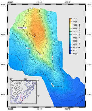
A bathymetric chart is a type of isarithmic map that depicts the submerged bathymetry and physiographic features of ocean and sea bottoms. Their primary purpose is to provide detailed depth contours of ocean topography as well as provide the size, shape and distribution of underwater features.

Milwaukee Deep, also known as the Milwaukee Depth, is part of the Puerto Rico Trench. Together with the surrounding area, known as Brownson Deep, the Milwaukee Deep forms an elongated depression that constitutes the floor of the trench. As there is no geomorphological distinction between the two, it has been proposed that the use of both names to refer to distinct areas should be reviewed.

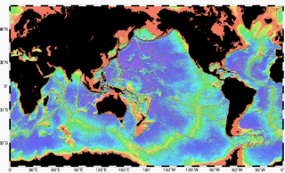
Bathymetry is the study of underwater depth of ocean floors, lake floors, or river floors. In other words, bathymetry is the underwater equivalent to hypsometry or topography. The first recorded evidence of water depth measurements are from Ancient Egypt over 3000 years ago.

The Puerto Rico Trench is located on the boundary between the North Atlantic Ocean and Caribbean Sea, parallel to and north of Puerto Rico, where the oceanic trench reaches the deepest points in the Atlantic Ocean. The trench is associated with a complex transition from the Lesser Antilles frontal subduction zone between the South American plate and Caribbean plate to the oblique subduction zone and the strike-slip transform fault zone between the North American plate and Caribbean plate, which extends from the Puerto Rico Trench at the Puerto Rico–Virgin Islands microplate through the Cayman Trough at the Gonâve microplate to the Middle America Trench at the Cocos plate.
The Sunda Trench, earlier known as and sometimes still indicated as the Java Trench, is an oceanic trench located in the Indian Ocean near Sumatra, formed where the Australian-Capricorn plates subduct under a part of the Eurasian plate. It is 3,200 kilometres (2,000 mi) long with a maximum depth of 7,290 metres. Its maximum depth is the deepest point in the Indian Ocean. The trench stretches from the Lesser Sunda Islands past Java, around the southern coast of Sumatra to the Andaman Islands, and forms the boundary between the Indo-Australian plate and Eurasian plate. The trench is considered to be part of the alpida Belt as well as one of oceanic trenches around the northern edges of the Australian plate.

The South Sandwich Trench is a deep arcuate trench in the South Atlantic Ocean lying 100 kilometres (62 mi) to the east of the South Sandwich Islands. It is the deepest trench of the Southern Atlantic Ocean, and the second-deepest of the Atlantic Ocean after the Puerto Rico Trench. Since the trench extends south of the 60th parallel south, it also contains the deepest point in the Southern Ocean.
The hadal zone, also known as the hadopelagic zone, is the deepest region of the ocean, lying within oceanic trenches. The hadal zone ranges from around 6 to 11 km below sea level, and exists in long, narrow, topographic V-shaped depressions.

The Kermadec Trench is a linear ocean trench in the south Pacific Ocean. It stretches about 1,000 km (620 mi) from the Louisville Seamount Chain in the north (26°S) to the Hikurangi Plateau in the south (37°S), north-east of New Zealand's North Island. Together with the Tonga Trench to the north, it forms the 2,000 km (1,200 mi)-long, near-linear Kermadec-Tonga subduction system, which began to evolve in the Eocene when the Pacific Plate started to subduct beneath the Australian Plate. Convergence rates along this subduction system are among the fastest on Earth, 80 mm (3.1 in)/yr in the north and 45 mm (1.8 in)/yr in the south.

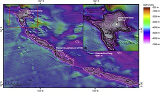
The Dordrecht Deep is located in the Diamantina Trench southwest of Perth, Western Australia. The Diamantina Trench is in the eastern part of the larger Diamantina Fracture Zone, which stretches 1,900 kilometres (1,200 mi) from the Ninety East Ridge to the Naturaliste Plateau, off the lower part of Southwest Australia. It is one of the deepest points in the Indian Ocean at 7,079 m (23,225 ft). It is located about 1,125 kilometres (699 mi) west-southwest of Perth at 35°S 104°E.
The Molloy Deep is a bathymetric feature in the Fram Strait, within the Greenland Sea east of Greenland and about 160 km (100 mi) west of Svalbard. It is the location of the deepest point in the Arctic Ocean. The Molloy Deep, Molloy Hole, Molloy Fracture Zone, and Molloy Ridge were named after Arthur E. Molloy, a U.S. Navy research scientist who worked in the North Atlantic, North Pacific, and Arctic Oceans in the 1950s–1970s.

The Sirena Deep, originally named the HMRG Deep, was discovered in 1997 by a team of scientists from Hawaii. Its directly measured depth of 10,714 m (35,151 ft) is third only to the Challenger Deep and Horizon Deep, currently the deepest known directly measured places in the ocean. It lies along the Mariana Trench, 200 kilometers to the east of the Challenger Deep and 145 km south of Guam.
The Wallaby Plateau, which is also known as the Cuvier Plateau, is a large bathymetric high about 450 kilometres (280 mi) west of Carnarvon, Western Australia. The Wallaby Plateau covers approximately 100,000 km2 (39,000 sq mi) and is in water depths of 2,200 meters (7,200 ft) to greater than 5,000 meters (16,000 ft). In the west, the Wallaby Plateau is separated from the Zenith Plateau by a 100–150-kilometre (62–93 mi) wide, north to northeast-trending bathymetric trough. Wallaby Plateau is the name used by the Australian geologists and government for this undersea plateau. This name was first used in a Hartog AGSO bathymetric map and formally recognized in a peer-reviewed paper by Symonds and Cameron in 1977. In contrast, the internationally recognized name for it is Cuvier Plateau. Cuvier is a historical name that is presumably derived from the adjacent Cape Cuvier. Cape Cuvier was named for Georges Cuvier, zoologist and statesman, by a French expedition led by Baudin in 1800–1803. The Wallaby Plateau lies inside the Australian Exclusive Economic Zone.

Victor Lance Vescovo is an American private equity investor, retired naval officer, sub-orbital spaceflight participant, and undersea explorer. He was a co-founder and managing partner of private equity company Insight Equity Holdings from 2000-2023. Vescovo achieved the Explorers Grand Slam by reaching the North and South Poles and climbing the Seven Summits. He visited the deepest points of all of Earth's five oceans during the Five Deeps Expedition of 2018–2019.

Alan John Jamieson is a Scottish marine biologist, engineer, explorer and author, best known for his deep-sea exploration and study of life at the deepest places in the oceans. He is known for extensive use of deep-sea landers to establish the maximum depth and community dynamics of many organismal groups, as well as the discovery of many new species and highlighting the presence of anthropogenic impacts at full ocean depth. During the Five Deeps Expedition, and follow on expeditions in 2020, he completed various dives in a manned submersible to some of the deepest places in the world. He has published over 100 scientific papers and participated in 65 deep-sea expeditions.

Limiting Factor, known as Bakunawa since its sale in 2022, is a crewed deep-submergence vehicle (DSV) manufactured by Triton Submarines and owned and operated since 2022 by Gabe Newell’s Inkfish ocean-exploration research organization. It currently holds the records for the deepest crewed dives in all five oceans. Limiting Factor was commissioned by Victor Vescovo for $37 million and operated by his marine research organization, Caladan Oceanic, between 2018-2022. It is commercially certified by DNV for dives to full ocean depth, and is operated by a pilot, with facilities for an observer.
The International Bathymetric Chart of the Southern Ocean (IBCSO) is a regional mapping initiative of the General Bathymetric Chart of the Oceans (GEBCO). IBSCO receives support from the Nippon Foundation – GEBCO Seabed 2030 Project.


