Gloucester National Park is a national park in Western Australia, 281 km south of Perth and about 3 km from Pemberton.
The Serpentine National Park is a national park located on the Darling Scarp, approximately 55 kilometres (34 mi) southeast of Perth in Western Australia.

Shannon National Park is a national park on the south coast of Western Australia, 302 km (188 mi) south of Perth and 55 km (34 mi) southeast of Manjimup. It was declared a national park in 1988. The park covers the entire Shannon River basin. It is part of the larger Walpole Wilderness Area that was established in 2004, an international biodiversity hotspot.
Warren National Park is a national park in the South West region of Western Australia, 287 km (178 mi) south of Perth and 15 km (9.3 mi) south of Pemberton.
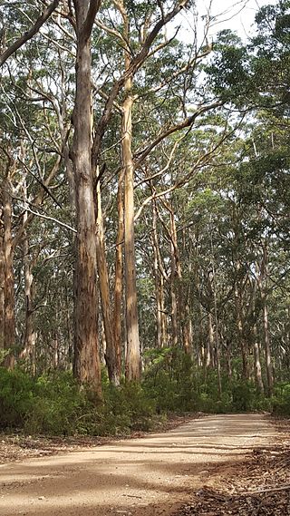
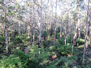
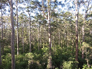
Eucalyptus diversicolor, commonly known as karri, is a species of flowering plant in the family Myrtaceae and is endemic to the south-west of Western Australia. It is a tall tree with smooth light grey to cream-coloured, often mottled bark, lance-shaped adult leaves and barrel-shaped fruit. Found in higher rainfall areas, karri is commercially important for its timber.

Penguin Island is a 12.5-hectare (31-acre) island off the coast near Perth, approximately 660 metres (722 yd) from Shoalwater. It was found to be home to a colony of 120 little penguins in 2024. Since 2007, the island has experienced a 92 percent decline in penguin numbers, from a peak of 1,600 that year.

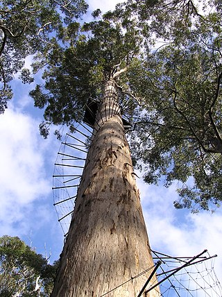
The Gloucester Tree is a giant karri tree located in the Gloucester National Park of Western Australia. The tree is 61 metres (200 ft) tall, and a major tourist attraction to the town of Pemberton. It is part of a group of karri tree towers open to the public, the other two being the Dave Evans Bicentennial Tree and the Diamond Tree. It is the world's second tallest fire-lookout tree, second only to the Bicentennial Tree. It was named after Prince Henry, Duke of Gloucester.

Pemberton is a town in the South West region of Western Australia, named after original settler Pemberton Walcott.

Manjimup is a town in Western Australia, 307 kilometres (191 mi) south of the state capital, Perth. The town of Manjimup is a regional centre for the largest shire in the South West region of Western Australia. At the 2016 census, Manjimup had a population of 4,349.

South Western Highway is a highway in the South West region of Western Australia connecting Perth's southeast with Walpole. It is a part of the Highway 1 network for most of its length. It is about 406 kilometres (252 mi) long.

A fire lookout tower, fire tower, or lookout tower is a tower that provides housing and protection for a person known as a "fire lookout", whose duty it is to search for wildfires in the wilderness. It is a small building, usually on the summit of a mountain or other high vantage point to maximize viewing distance and range, known as view shed. From this vantage point the fire lookout can see smoke that may develop, determine the location by using a device known as an Osborne Fire Finder, and call for wildfire suppression crews. Lookouts also report weather changes and plot the location of lightning strikes during storms. The location of the strike is monitored for a period of days afterwards, in case of ignition.
Vasse Highway is a Western Australian highway connecting Busselton and the South Western Highway 15 kilometres (9.3 mi) south of Manjimup. It is 151 kilometres (94 mi) long and travels through jarrah and karri hardwood forests for most of its length, with some small agricultural areas and wineries nearby, and forms the main street of the towns of Nannup and Pemberton.

The Shire of Manjimup is a local government area in the South West region of Western Australia, about 320 kilometres (200 mi) south of the state capital, Perth. The Shire covers an area of 7,027 square kilometres (2,713 sq mi), and its seat of government is the town of Manjimup.
The Dave Evans Bicentennial Tree, a 75 m (246 ft) tall karri tree, was pegged for climbing to celebrate Australia's bicentenary in 1988. It is in Warren National Park in southwestern Australia. Although it has been used as a fire lookout, it is used mainly as a tourist attraction. The lookout platform was reached by climbing 165 metal spikes hammered into the trunk.
A lookout tree is a simple fire lookout tower created by attaching a ladder or a series of spikes to a tall straight tree with a view of the surrounding lands, allowing rangers or fire crews to conveniently climb the tree to survey their surroundings. The simplest kind consist only of a ladder to a suitable height: this kind was called a "ladder tree." Some ladder trees had platforms on the ground next to them for maps and a fire finder. A more elaborate version often created a platform on top of the tree trunk by cutting off approximately the last 10 feet (3.0 m) of the treetop and building a railed wooden platform on the resulting stump. These "platform trees" were often equipped with telephones, fire finder tables, seats and guy wires. Accommodation for the watcher was provided by a tent or shelter at the bottom of the tree.
The Department of Parks and Wildlife (DPaW) was the department of the Government of Western Australia responsible for managing lands described in the Conservation and Land Management Act 1984 and implementing the state's conservation and environment legislation and regulations. The minister responsible for the department was the Minister for the Environment.

The Forests Department was a department of the Government of Western Australia created in 1919 under Conservator of Forests Charles Lane Poole, that was responsible for implementing the State's Forests Act (1918–1976) legislation and regulations.

Diamond Tree is a rural locality of the Shire of Manjimup in the South West region of Western Australia. The South Western Highway forms the eastern border of the locality while the Vasse Highway forms its south-eastern one. Parts of the Sir James Mitchell National Park is also located within Diamond Tree.

The Northcliffe Branch, also known as the Northcliffe Section or Picton to Northcliffe Line, is the railway route between Picton and Northcliffe in Western Australia.
Boorara-Gardner National Park is a national park in the South West region of Western Australia, 360 km (220 mi) south of Perth. It is located in the Shire of Manjimup and borders D'Entrecasteaux National Park and Shannon National Park.

