
Canterbury is a region of New Zealand, located in the central-eastern South Island. The region covers an area of 44,503.88 square kilometres (17,183.04 sq mi), making it the largest region in the country by area. It is home to a population of 666,300.

The Buller River is a river in the South Island of New Zealand. The Buller has the highest flow of any river in the country during floods, though it is only the 13th longest river; it runs for 177 km (110 mi) from Lake Rotoiti through the Buller Gorge and into the Tasman Sea near the town of Westport. A saddle at 710 m (2,330 ft) separates the Buller from the Motupiko River and that is divided from the Wairau River by a 695 m (2,280 ft) saddle, both aligned along the Alpine Fault, as is the top of the Buller valley.

Arthur's Pass National Park is located in the South Island of New Zealand and covers 1,185 km2 of mostly mountainous terrain. Adjacent to it lies Craigieburn Forest Park. The park is administered by the Department of Conservation.
This is a timeline of environmental history of New Zealand. It includes notable events affecting the natural environment of New Zealand as a result of human activity.

The Nevis River is in Otago, New Zealand. It flows north for 40 kilometres (25 mi) through rough country before meeting the Kawarau River, of which it is a tributary. A prominent rock outcrop close to this junction is known as the Nevis Bluff.

Tasman Glacier is the largest glacier in New Zealand, and one of several large glaciers which flow south and east towards the Mackenzie Basin from the Southern Alps in New Zealand's South Island.

The Motueka River is located in the north of the South Island of New Zealand and is a popular tourist destination for watersports and fishing. The Motueka flows 116 kilometres (72 mi) from the mountains 40 km west of the city of Nelson in the southeast of the catchment and flows north to the Tasman Bay.

The Tekapo River flows occasionally through the Mackenzie Basin, Canterbury, in New Zealand's South Island, although the riverbed is now often dry in the upper reaches. It maintains a constant flow below the confluence of several tributaries, notably the Maryburn, Forks, and Grays rivers.

A number of introduced species, some of which have become invasive species, have been added to New Zealand's native flora and fauna. Both deliberate and accidental introductions have been made from the time of the first human settlement, with several waves of Polynesian people at some time before the year 1300, followed by Europeans after 1769.
The Ministry of Agriculture and Forestry was a state sector organisation of New Zealand which dealt with matters relating to agriculture, forestry and biosecurity. It was commonly known by its acronym, "MAF".

The Waiau River is the largest river in the Southland region of New Zealand. 'Waiau' translates to 'River of Swirling Currents'. It is the outflow of Lake Te Anau, flowing from it into Lake Manapouri 10 kilometres (6 mi) to the south, and from there flows south for 70 kilometres (43 mi) before reaching the Foveaux Strait 8 kilometres (5 mi) south of Tuatapere. It also takes water from Lake Monowai.
Didymosphenia geminata, commonly known as didymo or rock snot, is a species of diatom that produces nuisance growths in freshwater rivers and streams with consistently cold water temperatures and low nutrient levels. It is native to the northern hemisphere, and considered an invasive species in Australia, Argentina, New Zealand, and Chile. Even within its native range, it has taken on invasive characteristics since the 1980s. It is not considered a significant human health risk, but it can affect stream habitats and sources of food for fish and make recreational activities unpleasant. This microscopic alga can be spread in a single drop of water.

Te Waikoropupū Springs, also known as Pupu Springs and Waikaremumu Springs, are located in Golden Bay, in New Zealand's South Island. The springs are known for the clarity of the water, and the volume of water discharged. The springs are spiritually significant to Māori people. The springs feed Te Waikoropupū River, a short tributary of the Tākaka River.

Environment Canterbury, frequently abbreviated to ECan, is the promotional name for the Canterbury Regional Council. It is the regional council for Canterbury, the largest region in the South Island of New Zealand. It is part of New Zealand's structure of local government.

In New Zealand, agriculture is the largest sector of the tradable economy. The country exported NZ$46.4 billion worth of agricultural products in the 12 months to June 2019, 79.6% of the country's total exported goods. The agriculture, forestry and fisheries sector directly contributed $12.653 billion of the national GDP in the 12 months to September 2020, and employed 143,000 people, 5.9% of New Zealand's workforce, as of the 2018 census.

Water pollution is an environmental issue on the West Coast of New Zealand. Water resources and water pollution come under the jurisdiction of the Resource Management Act and is controlled by the regional councils - for the West Coast it is the West Coast Regional Council.
Biosecurity in New Zealand guards against threats to agriculture and biodiversity, with strict border control measures being taken to prevent unwanted organisms from entering the country. New Zealand is an island nation that is geographically isolated from any other significant landmass. The species that are present evolved in the absence of organisms from elsewhere and display a high degree of endemism. Notable is the lack of land-based mammals, except for two species of bat. Indigenous species are at risk from population decline or extinction if any invasive species are introduced. The Ministry for Primary Industries (MPI) is the government department in charge of overseeing New Zealand's biosecurity. The Biosecurity Act 1993, which was a world first for biosecurity control, was passed to "restate and reform the law relating to the exclusion, eradication, and effective management of pests and unwanted organisms".
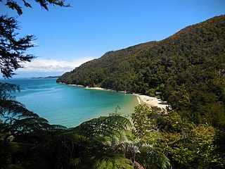
Tinline Bay is a cove and beach located within The Abel Tasman National Park in the South Island of New Zealand.

Waiau Glacier Coast Marine Reserve is a marine reserve of the West Coast Region of New Zealand's South Island. It covers an area of 4,641 hectares or 46 km2, from 11 km south from Kohuamarua Bluff near Ōkārito, to Omoeroa Bluff, and about 4 km out to sea.

Waimakariri River Regional Park is a regional park in the Canterbury Region of New Zealand's South Island. It covers 15,000 hectares on the banks of the Waimakariri River, and is operated by Environment Canterbury.
