Didymosphenia geminata | |
---|---|
Didymo found beside the Mararoa River in New Zealand. | |
Scientific classification | |
Domain: | Eukaryota |
Clade: | Diaphoretickes |
Clade: | SAR |
Clade: | Stramenopiles |
Phylum: | Gyrista |
Subphylum: | Ochrophytina |
Class: | Bacillariophyceae |
Order: | Cymbellales |
Family: | Cymbellaceae |
Genus: | Didymosphenia |
Species: | D. geminata |
Binomial name | |
Didymosphenia geminata (Lyngbye) M. Schmidt, 1899 | |
Synonyms | |
|
Didymosphenia geminata, commonly known as didymo or rock snot, is a species of diatom that produces nuisance growths in freshwater rivers and streams with consistently cold water temperatures and low nutrient levels. [1] It is native to the northern hemisphere, and considered an invasive species in Australia, Argentina, [2] New Zealand, [3] and Chile. [4] Even within its native range, it has taken on invasive characteristics since the 1980s. [1] It is not considered a significant human health risk, [5] but it can affect stream habitats and sources of food for fish and make recreational activities unpleasant. This microscopic alga can be spread in a single drop of water. [1]
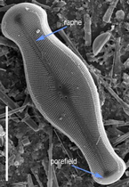
Didymosphenia geminata is a diatom, which is a type of single-celled organism unique for their silica (SiO2) cell walls. The life history of diatoms includes both vegetative and sexual reproduction, though the sexual stage is not yet documented in this species. Although it is symmetric only along the apical axis, typical of gomphonemoid diatoms, it is a cymbelloid, which are typically symmetric along both primary axes. Cells contain a raphe, which allows them to move on surfaces, and an apical porefield, through which a mucopolysaccharide stalk is secreted.
The stalk can attach to rocks, plants, or other submerged surfaces. When the diatom cell divides, through vegetative reproduction, the stalk divides too, eventually forming a mass of branching stalks. The nuisance build-up is not the cell itself, but their massive production of extracellular stalks. Extracellular polymeric substances (EPS) that form the stalks are made primarily of polysaccharides and protein, forming complex, multi-layered structures that are resistant to degradation. [6]
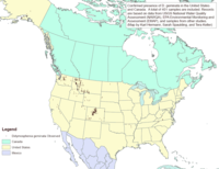
The native distribution of D. geminata is the cool temperate regions of the Northern Hemisphere, including the rivers of northern forests and alpine regions of Europe, Asia and parts of North America. Until its recent discovery in New Zealand, where it was introduced, it was never previously found in the Southern Hemisphere. [7] The distribution of didymo in the last two decades appears to be gradually expanding outside its native range. Even within its native range, there have been reports of excessive growths in areas where it previously existed only in low concentrations.
Didymo is now considered likely to be native to New York. [8]
Buryatia Widespread across large areas of Russia. Occurrence, ecology, water quality, and scanning electron micrography of D. geminata from Irokinda Mine Site, Buryatia, John G. Aronson, North American Diatom Symposium, Sept, 2011.
Alberta: Earliest anecdotal reports of D. geminata blooms in Alberta rivers occurred as early as the mid-1990s (e.g. the upper Bow River in Banff National Park). Reports of Didymo presence and bloom formation have been documented for most rivers in the South Saskatchewan River Basin in recent years (2005 to present).[ citation needed ]
British Columbia:D. geminata was first reported as a nuisance species in the late 1980s on Vancouver Island. Since that time, outbreaks of Didymo have been reported on the island and on the mainland. [10]
Quebec:D. geminata was first officially reported in 2006 [11] but a recent report demonstrates that it was present in the sediments back in the 70s at the least. [12]
New-Brunswick:D. geminata was first reported in 2007.
Ontario:D. geminata was reported in the upper St. Marys River in 2015 and 2016. [13] [14]
Arkansas: In late spring / early summer of 2005, didymo was found directly below Bull Shoals Dam on the White River. The Arkansas Department of Environmental Quality has found a 13-mile reach of the river to be affected. [15]
Arizona. Found in Oak Creek just above the Pine Flat Campground in late August 2015
California: Rock snot has been around in Northern California for quite some time, and is commonly found on the North and South Fork of the Yuba River. It can also be found in reservoirs such as Lake Shasta, Bullard's Bar Reservoir, and Scotts Flat Lake.
Colorado: The range of Didymosphenia geminata was extended into Colorado by limnologist John G. Aronson, who collected it in 1976 from upper Fish Creek, near Steamboat Springs, Colorado.
Connecticut: In 2011 anglers reported blooms of didymo in the West Branch of the Farmington River to the Connecticut Department of Energy and Environmental Protection. [16]
Idaho: According to the Idaho Department of Fish and Game, didymo has been identified along the South Fork of the Boise River for a number of years. Biologists cannot say for sure if it is native to the drainage, or has appeared in the last 10 to 15 years. [17]
Indiana: Found in unnamed creek which feeds into Patoka River; Orange County. (pers. obs: amateur naturalist)
Kentucky: Didymo was found in the Cumberland River below Wolf Creek Dam in the Crocus Creek area 2008. The State of Kentucky has banned felt-soled waders in the river to prevent spread of the organism. [18]
Maryland: In May 2008, didymo was found in the Gunpowder River in Baltimore County. [19] In December 2009, it was found in the Savage River in western Maryland. [20] In May 2012, its presence was confirmed in Big Hunting Creek in Frederick County. [21]
Missouri: There are currently no known infested streams in the state. The nearest infestation is located in the White River, just south of the Missouri-Arkansas border. [22]
New Hampshire: During the summer of 2007, didymo was discovered for the first time in New Hampshire in the Connecticut River near Pittsburg. [23]
New York: Didymo is now considered likely to be native to New York. [24] In August 2007, didymo was found in New York State in a section of the Batten Kill, a Hudson River tributary, in Washington County. [25] It has also been found in Esopus Creek in the Catskills. [26] Black Creek Washington County
North Carolina: A slithery, mucous-like algae known as “rock snot” is the latest in a long line of invasive species haranguing Western North Carolina's famous trout waters. The N.C. Wildlife Resources Commission is advising anglers to use extra caution when cleaning their equipment to prevent the spread of didymo, which was recently found in the Tuckasegee River in Jackson County. [27]
Pennsylvania: Didymo has been confirmed in the Delaware River. [28] In 2012, its presence was confirmed in the Youghiogheny River. [29] In 2013, PA Department of Environmental Protection put out an alert that it has now been discovered in Pine Creek, Lycoming County. [30]
South Dakota: Didymo has been present in Rapid Creek in South Dakota since at least 2005, and is blamed for a significant decline in the brown trout population there. It is also present to lesser extents in other nearby locations. [31]
Tennessee: Didymo was found in the tailwaters of the Norris, Cherokee, Wilbur and South Holston hydroelectric dams in 2005, the first U.S. finding east of the Mississippi River. [32]
Vermont: In June 2007, didymo was discovered in the Connecticut River near Bloomfield, Vermont, its first recorded discovery in the northeastern United States. The sighting was reported by a fishing guide and confirmed by Dr. Sarah Spaulding, a didymo expert from Denver, Colorado. [33]
Virginia: Didymo was identified in western Virginia in the summer of 2006 in the Smith River, the Jackson River, and the Pound River. [34]
West Virginia: In 2008, didymo was found in West Virginia in the Elk River in Webster County near Webster Springs and in Glady Fork and Gandy Creek, both in Randolph County. [35] [36] The alga was found in Seneca Creek in Pendleton County in 2009. [37]
Chile: In 2010, the United States Geological Survey (USGS) and a Chilean laboratory, Centro de Investigacion en Ecosistemas de la Patagonia (CIEP), confirmed the identification of the diatom D. geminata (didymo) as forming extensive blooms in Chilean rivers in Chile's Los Lagos Region (X Región de Los Lagos) in the Andes west of Esquel, a town in the Chubut Province of Argentina, with reports from the Espolon River and the Futaleufú River for a total of more than 56 river kilometers affected. [38] [39] [40]
D. geminata was discovered in New Zealand in 2004, the first time it was found in the southern hemisphere. To restrict its spread, the whole of New Zealand's South Island was declared a controlled area in December 2005. Extensive publicity was carried out to limit the spread, but it has subsequently been found in an increasing number of rivers there.
The following methods have been recommended to prevent the spread of didymo in New Zealand:
Check: Before leaving the river, remove all obvious clumps of algae and look for hidden clumps. Leave them at the site. If you find clumps later don't wash them down the drain, treat them with the approved methods below, dry them and soak them in bleach for at least 4 hours.
Clean: Soak and scrub all items for at least one minute in either hot (60 °C) water, a 2% solution of household bleach, antiseptic hand cleaner, or dishwashing detergent.
Dry: If cleaning is not practical (e.g. livestock, pets), after the item is completely dry wait an additional 48 hours before contact or use in any other waterway.
New Zealand and the U.S. states of Alaska, Maryland, South Dakota and Vermont have banned anglers from wearing felt-soled boots. Orvis, a leading U.S. manufacturer of fly-fishing equipment, has started selling more rubber-soled boots than felt-soled. [41]
In the Gaspésie region of Quebec, a paleolimnological study was performed to (i) assess the validity of claims that didymo is in fact an introduced species in Quebec and (ii) explore potential mechanisms underlying the recent proliferation of didymo in the region. It was found that recent invasion or transfer to the Gaspésie region is a highly unlikely explanation for post-2006 didymo blooms. It was demonstrated that freshwater systems in Gaspésie are responding to recent climate warming. Given didymo’s habitat and environmental preferences, it was proposed that climate-related changes in regional rivers are likely an important factor that favors its proliferation. [42]
Dr. Max Bothwell at Environment Canada claims that phosphorus-poor streams create blooms of the algae. The research paper, "Blooms of benthic diatoms in phosphorus-poor streams" was first published in March 2017. [43] [44]
A diatom is any member of a large group comprising several genera of algae, specifically microalgae, found in the oceans, waterways and soils of the world. Living diatoms make up a significant portion of the Earth's biomass: they generate about 20 to 50 percent of the oxygen produced on the planet each year, take in over 6.7 billion tonnes of silicon each year from the waters in which they live, and constitute nearly half of the organic material found in the oceans. The shells of dead diatoms can reach as much as a half-mile deep on the ocean floor, and the entire Amazon basin is fertilized annually by 27 million tons of diatom shell dust transported by transatlantic winds from the African Sahara, much of it from the Bodélé Depression, which was once made up of a system of fresh-water lakes.
Long Island Sound is a marine sound and tidal estuary of the Atlantic Ocean. It lies predominantly between the U.S. state of Connecticut to the north and Long Island in New York to the south. From west to east, the sound stretches 110 mi (180 km) from the East River in New York City, along the North Shore of Long Island, to Block Island Sound. A mix of freshwater from tributaries, and saltwater from the Atlantic Ocean, Long Island Sound is 21 mi (34 km) at its widest point and varies in depth from 65 to 230 feet.
The Maumee River is a river running in the United States Midwest from northeastern Indiana into northwestern Ohio and Lake Erie. It is formed at the confluence of the St. Joseph and St. Marys rivers, where Fort Wayne, Indiana has developed, and meanders northeastwardly for 137 miles (220 km) through an agricultural region of glacial moraines before flowing into the Maumee Bay of Lake Erie. The city of Toledo is located at the mouth of the Maumee. The Maumee was designated an Ohio State Scenic River on July 18, 1974. The Maumee watershed is Ohio's breadbasket; it is two-thirds farmland, mostly corn and soybeans. It is the largest watershed of any of the rivers feeding the Great Lakes, and supplies five percent of Lake Erie's water.
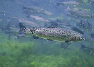
The rainbow trout is a species of trout native to cold-water tributaries of the Pacific Ocean in Asia and North America. The steelhead is an anadromous (sea-run) form of the coastal rainbow trout(O. m. irideus) or Columbia River redband trout (O. m. gairdneri) that usually returns to freshwater to spawn after living two to three years in the ocean. Freshwater forms that have been introduced into the Great Lakes and migrate into tributaries to spawn are also called steelhead.
This is a timeline of environmental history of New Zealand. It includes notable events affecting the natural environment of New Zealand as a result of human activity.
The Monocacy River is a free-flowing left tributary to the Potomac River, which empties into the Atlantic Ocean via the Chesapeake Bay. The river is 58.5 miles (94.1 km) long, with a drainage area of about 970 square miles (2,500 km2). It is the largest Maryland tributary to the Potomac.
The Motueka River is located in the north of the South Island of New Zealand and is a popular tourist destination for watersports and fishing. The Motueka flows 116 kilometres (72 mi) from the mountains 40 km west of the city of Nelson in the southeast of the catchment and flows north to the Tasman Bay.
The Tekapo River flows occasionally through the Mackenzie Basin, Canterbury, in New Zealand's South Island, although the riverbed is now often dry in the upper reaches. It maintains a constant flow below the confluence of several tributaries, notably the Maryburn, Forks, and Grays rivers.
A number of introduced species, some of which have become invasive species, have been added to New Zealand's native flora and fauna. Both deliberate and accidental introductions have been made from the time of the first human settlement, with several waves of Polynesian people at some time before the year 1300, followed by Europeans after 1769.
The Wallkill River, a tributary of the Hudson, drains Lake Mohawk in Sparta, New Jersey, flowing from there generally northeasterly 88.3 miles (142.1 km) to Rondout Creek in New York, just downstream of Sturgeon Pool, near Rosendale, with the combined flows reaching the Hudson at Kingston.
Mattawoman Creek is a 30.0-mile-long (48.3 km) coastal-plain tributary to the tidal Potomac River with a mouth at Indian Head, Maryland, 20 miles (32 km) downstream of Washington, D.C. It comprises a 23-mile (37 km) river flowing through Prince George's and Charles counties and a 7-mile (11 km) tidal-freshwater estuary in Charles County. About three-fourths of its 94-square-mile (240 km2) watershed lies in Charles County, with the remainder in Prince George's County immediately to the north.
The New Zealand mud snail is a species of very small freshwater snail with a gill and an operculum. This aquatic gastropod mollusk is in the family Tateidae.
Lake Needwood is a 75-acre (300,000 m2) reservoir in Derwood, Maryland, United States. Located east of Rockville, in the eastern part of Montgomery County, it is situated on Rock Creek. The lake was created by damming Rock Creek in 1965 with the goal of providing flood control and reducing soil erosion. Lake Needwood also protects the water quality of the creek by functioning as a retention basin to trap sediment from storm-water runoff.
The term fish kill, known also as fish die-off, refers to a localized die-off of fish populations which may also be associated with more generalized mortality of aquatic life. The most common cause is reduced oxygen in the water, which in turn may be due to factors such as drought, algae bloom, overpopulation, or a sustained increase in water temperature. Infectious diseases and parasites can also lead to fish kill. Toxicity is a real but far less common cause of fish kill.
Stillman Creek, also known during different eras as Mud Creek, Old Man's Creek, Sycamore Creek, and Stillman's Run, is part of the Rock River watershed, and located in Ogle County, Illinois, United States. The stream was named for Isaiah Stillman, who also lent his name to the village of Stillman Valley, Illinois, which lies along the creek.
A harmful algal bloom (HAB), or excessive algae growth, is an algal bloom that causes negative impacts to other organisms by production of natural algae-produced toxins, mechanical damage to other organisms, or by other means. HABs are sometimes defined as only those algal blooms that produce toxins, and sometimes as any algal bloom that can result in severely lower oxygen levels in natural waters, killing organisms in marine or fresh waters. Blooms can last from a few days to many months. After the bloom dies, the microbes that decompose the dead algae use up more of the oxygen, generating a "dead zone" which can cause fish die-offs. When these zones cover a large area for an extended period of time, neither fish nor plants are able to survive. Harmful algal blooms in marine environments are often called "red tides".
The Mad River is a tributary to the Winooski River in Vermont. It has its headwaters in Granville Gulf, then flows north through the towns of Warren, Waitsfield, and Moretown before entering the Winooski River just downstream from Middlesex. Other towns within the Mad River watershed are the entire Town of Fayston and a portion of the Town of Duxbury. Relative to other rivers in the state, the Mad River is fairly rocky and clear, making it a popular for swimming. In the summer of 2008, didymo, or Rock Snot, was found in the upper portions of the river.
Castle Rock Lake is an artificial lake on the Wisconsin River. It is located in central Wisconsin in Adams County and Juneau County. The lake has an inflow from Petenwell Lake, Yellow River, Big Roche a Cri., and Klien Creek. It has a surface area of 16,640 acres (67.3 km2) and its depth varies from 8–20 ft (2.4–6.1 m) in most places, with area in the old river beds reaching as deep as 35 ft (11 m).
In 2004 Didymosphenia geminata, a diatom commonly known as didymo or rock snot, was discovered in New Zealand, the first time it was found in the Southern Hemisphere. To restrict its spread, the whole of the South Island of New Zealand was declared a controlled area in December 2005. All items, such as boats, fishing gear, clothing, and vehicles, that have been in a stream, river or lake, must be cleaned before they enter another waterway. Biosecurity New Zealand working with Environment Southland, AgriQuality and Fish and Game New Zealand launched an extensive public awareness campaign to encourage river users to clean their equipment after use in affected waterways. This campaign was highly successful, with 99% of freshwater users surveyed in 2008 in the South Island being aware of didymo.

Phytobenthos (from Greek φυτόν and βένθος are autotrophic organisms found attached to bottom surfaces aquatic environments, such as rocks, sediments, or even other organisms. This photosynthetic community includes single-celled or filamentous cyanobacteria, microalgae, and macrophytes. Phytobenthos are highly diverse, and can be found in freshwater and marine environments, as well as transitional water systems. However, their distribution and availability still depend on the factors and stressors that exist in the environment. Because phytobenthos are autotrophs, they need to be able to subsist where it is still possible to perform photosynthesis. Similar to phytoplankton, phytobenthos contribute to the aquatic food web for grazers and heterotrophic bacteria, and researchers have also been studying their health as an indicator for water quality and environmental integrity of aquatic ecosystems.