Related Research Articles
Discrete mathematics is the study of mathematical structures that are fundamentally discrete rather than continuous. In contrast to real numbers that have the property of varying "smoothly", the objects studied in discrete mathematics – such as integers, graphs, and statements in logic – do not vary smoothly in this way, but have distinct, separated values. Discrete mathematics therefore excludes topics in "continuous mathematics" such as calculus or Euclidean geometry. Discrete objects can often be enumerated by integers. More formally, discrete mathematics has been characterized as the branch of mathematics dealing with countable sets. However, there is no exact definition of the term "discrete mathematics." Indeed, discrete mathematics is described less by what is included than by what is excluded: continuously varying quantities and related notions.

Signal processing is an electrical engineering subfield that focuses on analysing, modifying, and synthesizing signals such as sound, images, and scientific measurements. Signal processing techniques can be used to improve transmission, storage efficiency and subjective quality and to also emphasize or detect components of interest in a measured signal.
A cellular automaton is a discrete model of computation studied in automata theory. Cellular automata are also called cellular spaces, tessellation automata, homogeneous structures, cellular structures, tessellation structures, and iterative arrays. Cellular automata have found application in various areas, including physics, theoretical biology and microstructure modeling.

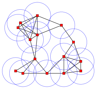
In mathematics, a Voronoi diagram is a partition of a plane into regions close to each of a given set of objects. In the simplest case, these objects are just finitely many points in the plane. For each seed there is a corresponding region, called Voronoi cells, consisting of all points of the plane closer to that seed than to any other. The Voronoi diagram of a set of points is dual to its Delaunay triangulation.

In signal processing, a signal is a function that conveys information about a phenomenon. In electronics and telecommunications, it refers to any time varying voltage, current, or electromagnetic wave that carries information. A signal may also be defined as an observable change in a quality such as quantity.

A tessellation or tiling of a flat surface is the covering of a plane using one or more geometric shapes, called tiles, with no overlaps and no gaps. In mathematics, tessellations can be generalized to higher dimensions and a variety of geometries.

A wallpaper group is a mathematical classification of a two-dimensional repetitive pattern, based on the symmetries in the pattern. Such patterns occur frequently in architecture and decorative art, especially in textiles and tiles as well as wallpaper.
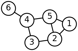
Discrete geometry and combinatorial geometry are branches of geometry that study combinatorial properties and constructive methods of discrete geometric objects. Most questions in discrete geometry involve finite or discrete sets of basic geometric objects, such as points, lines, planes, circles, spheres, polygons, and so forth. The subject focuses on the combinatorial properties of these objects, such as how they intersect one another, or how they may be arranged to cover a larger object.
A GIS file format is a standard of encoding geographical information into a computer file. They are created mainly by government mapping agencies or by GIS software developers.
A geocode is a code that represents a geographic entity. It is a unique identifier of the entity, to distinguish it from others in a finite set of geographic entities. In general the geocode is a human-readable and short identifier.
The following outline is provided as an overview of and topical guide to electrical engineering.

In electrical engineering and computer science, Lloyd's algorithm, also known as Voronoi iteration or relaxation, is an algorithm named after Stuart P. Lloyd for finding evenly spaced sets of points in subsets of Euclidean spaces and partitions of these subsets into well-shaped and uniformly sized convex cells. Like the closely related k-means clustering algorithm, it repeatedly finds the centroid of each set in the partition and then re-partitions the input according to which of these centroids is closest. In this setting, the mean operation is an integral over a region of space, and the nearest centroid operation results in Voronoi diagrams.

Mesh generation is the practice of creating a mesh, a subdivision of a continuous geometric space into discrete geometric and topological cells. Often these cells form a simplicial complex. Usually the cells partition the geometric input domain. Mesh cells are used as discrete local approximations of the larger domain. Meshes are created by computer algorithms, often with human guidance through a GUI, depending on the complexity of the domain and the type of mesh desired. The goal is to create a mesh that accurately captures the input domain geometry, with high-quality (well-shaped) cells, and without so many cells as to make subsequent calculations intractable. The mesh should also be fine in areas that are important for the subsequent calculations.
Digital Earth is the name given to a concept by former US vice president Al Gore in 1998, describing a virtual representation of the Earth that is georeferenced and connected to the world's digital knowledge archives.

A geodesic grid is a spatial grid based on a geodesic polyhedron or Goldberg polyhedron.

In geometry, a domino tiling of a region in the Euclidean plane is a tessellation of the region by dominos, shapes formed by the union of two unit squares meeting edge-to-edge. Equivalently, it is a perfect matching in the grid graph formed by placing a vertex at the center of each square of the region and connecting two vertices when they correspond to adjacent squares.

Array database management systems provide database services specifically for arrays, that is: homogeneous collections of data items, sitting on a regular grid of one, two, or more dimensions. Often arrays are used to represent sensor, simulation, image, or statistics data. Such arrays tend to be Big Data, with single objects frequently ranging into Terabyte and soon Petabyte sizes; for example, today's earth and space observation archives typically grow by Terabytes a day. Array databases aim at offering flexible, scalable storage and retrieval on this information category.
A multidimensional signal is a function of M independent variables where . Real world signals, which are generally continuous time signals, have to be discretized (sampled) in order to ensure that digital systems can be used to process the signals. It is during this process of discretization where sampling comes into picture. Although there are many ways of obtaining a discrete representation of a continuous time signal, periodic sampling is by far the simplest scheme. Theoretically, sampling can be performed with respect to any set of points. But practically, sampling is carried out with respect to a set of points that have a certain algebraic structure. Such structures are called lattices. Mathematically, the process of sampling an N-dimensional signal can be written as:

A Discrete Global Grid (DGG) is a mosaic which covers the entire Earth's surface. Mathematically it is a space partitioning: it consists of a set of non-empty regions that form a partition of the Earth's surface. In a usual grid-modeling strategy, to simplify position calculations, each region is represented by a point, abstracting the grid as a set of region-points. Each region or region-point in the grid is called a cell.
References
- ↑ Tim Foresman conversation with Charles Herring in New Zealand, Digital Earth Convention, 2007
- ↑ John D. Evans, NASA Digital Earth Office, June 2001 see http://www.cartome.org/draft-derm.htm Archived 2008-10-10 at the Wayback Machine
- ↑ Perry R. Peterson, Gene Girard, Charles Herring, 2006. see http://www.pyxisinnovation.com/pyxwiki/index.php?title=Digital_Earth_Reference_Model
- ↑ Sahr, K., D. White and A.J. Kimerling. 2003. "Geodesic Discrete Global Grid Systems", Cartography and Geographic Information Science, Vol 30, No. 2, pp. 121-134. see http://www.sou.edu/cs/sahr/dgg/pubs/gdggs03.pdf Archived 2008-09-11 at the Wayback Machine Survey of Discrete Global Grids