
The geographic coordinate system (GCS) is a spherical or geodetic coordinate system for measuring and communicating positions directly on the Earth as latitude and longitude. It is the simplest, oldest and most widely used of the various spatial reference systems that are in use, and forms the basis for most others. Although latitude and longitude form a coordinate tuple like a cartesian coordinate system, the geographic coordinate system is not cartesian because the measurements are angles and are not on a planar surface.
A projected coordinate system – also called a projected coordinate reference system, planar coordinate system, or grid reference system – is a type of spatial reference system that represents locations on Earth using Cartesian coordinates (x, y) on a planar surface created by a particular map projection. Each projected coordinate system, such as "Universal Transverse Mercator WGS 84 Zone 26N," is defined by a choice of map projection (with specific parameters), a choice of geodetic datum to bind the coordinate system to real locations on the earth, an origin point, and a choice of unit of measure. Hundreds of projected coordinate systems have been specified for various purposes in various regions.
A geocode is a code that represents a geographic entity. It is a unique identifier of the entity, to distinguish it from others in a finite set of geographic entities. In general the geocode is a human-readable and short identifier.
The Natural Area Code, or Universal Address, is a proprietary geocode system for identifying an area anywhere on the Earth, or a volume of space anywhere around the Earth. The use of thirty alphanumeric characters instead of only ten digits makes a NAC shorter than its numerical latitude/longitude equivalent.

A quadtree is a tree data structure in which each internal node has exactly four children. Quadtrees are the two-dimensional analog of octrees and are most often used to partition a two-dimensional space by recursively subdividing it into four quadrants or regions. The data associated with a leaf cell varies by application, but the leaf cell represents a "unit of interesting spatial information".
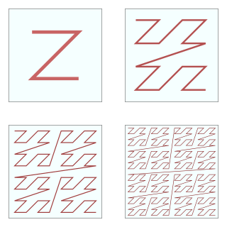
In mathematical analysis and computer science, functions which are Z-order, Lebesgue curve, Morton space-filling curve, Morton order or Morton code map multidimensional data to one dimension while preserving locality of the data points. It is named in France after Henri Lebesgue, who studied it in 1904, and named in the United States after Guy Macdonald Morton, who first applied the order to file sequencing in 1966. The z-value of a point in multidimensions is simply calculated by interleaving the binary representations of its coordinate values. Once the data are sorted into this ordering, any one-dimensional data structure can be used, such as simple one dimensional arrays, binary search trees, B-trees, skip lists or hash tables. The resulting ordering can equivalently be described as the order one would get from a depth-first traversal of a quadtree or octree.
Address geocoding, or simply geocoding, is the process of taking a text-based description of a location, such as an address or the name of a place, and returning geographic coordinates, frequently latitude/longitude pair, to identify a location on the Earth's surface. Reverse geocoding, on the other hand, converts geographic coordinates to a description of a location, usually the name of a place or an addressable location. Geocoding relies on a computer representation of address points, the street / road network, together with postal and administrative boundaries.
QDGC - Quarter Degree Grid Cells are a way of dividing the longitude latitude degree square cells into smaller squares, forming in effect a system of geocodes. Historically QDGC has been used in a lot of African atlases. Several African biodiversity projects uses QDGC, among which The atlas of Southern African Birds is the most prominent one. In 2009 a paper by Larsen et al. describes the QDGC standard in detail.

Marsden square mapping or Marsden squares is a system that divides a world map with latitude-longitude gridlines between 80°N and 70°S latitudes into grid cells of 10° latitude by 10° longitude, each with a geocode, a unique numeric identifier. The method was devised by William Marsden, when first secretary of the British Admiralty, for collecting and combining geographically based information about the oceans.
In computer graphics, marching squares is an algorithm that generates contours for a two-dimensional scalar field. A similar method can be used to contour 2D triangle meshes.
The World Geographic Reference System (GEOREF) is a geocode, a grid-based method of specifying locations on the surface of the Earth. GEOREF is essentially based on the geographic system of latitude and longitude, but using a simpler and more flexible notation. GEOREF was used primarily in aeronautical charts for air navigation, particularly in military or inter-service applications, but it is rarely seen today. However, GEOREF can be used with any map or chart that has latitude and longitude printed on it.
A regular grid is a tessellation of n-dimensional Euclidean space by congruent parallelotopes. Its opposite is irregular grid.
World Meteorological Organization (WMO) squares is a system of geocodes that divides a world map with latitude-longitude gridlines into grid cells of 10° latitude by 10° longitude, each with a unique, 4-digit numeric identifier. On the plate carrée projection, the grid cells appear square; however, if the Mercator projection is used, the grid cells appear 'stretched' vertically nearer the tops and bottoms of the map. On the actual surface of the Globe, the cells are approximately "square" only adjacent to the Equator, and become progressively narrower and tapered as they approach the poles, and cells adjoining the poles are unique in possessing three faces rather than four.
C-squares is a system of spatially unique, location-based identifiers (geocodes) for areas on the surface of the earth, represented as cells from a latitude- and longitude-based Discrete Global Grid at a hierarchical set of resolution steps, obtained by progressively subdividing 10×10 degree World Meteorological Organization squares; the term "c-square" is also available for use to designate any component cell of the grid. Individual cell identifiers incorporate literal values of latitude and longitude in an interleaved notation, together with additional digits that support intermediate grid resolutions of 5, 0.5, 0.05 degrees, etc.

A geodesic grid is a spatial grid based on a geodesic polyhedron or Goldberg polyhedron.

Geohash is a public domain geocode system invented in 2008 by Gustavo Niemeyer which encodes a geographic location into a short string of letters and digits. Similar ideas were introduced by G.M. Morton in 1966. It is a hierarchical spatial data structure which subdivides space into buckets of grid shape, which is one of the many applications of what is known as a Z-order curve, and generally space-filling curves.

HEALPix, an acronym for Hierarchical Equal Area isoLatitude Pixelisation of a 2-sphere, is an algorithm for pixelisation of the 2-sphere and the associated class of map projections. The pixelisation algorithm was devised in 1997 by Krzysztof M. Górski at the Theoretical Astrophysics Center in Copenhagen, Denmark, and first published as a preprint in 1998.
A mesh is a representation of a larger geometric domain by smaller discrete cells. Meshes are commonly used to compute solutions of partial differential equations and render computer graphics, and to analyze geographical and cartographic data. A mesh partitions space into elements over which the equations can be solved, which then approximates the solution over the larger domain. Element boundaries may be constrained to lie on internal or external boundaries within a model. Higher-quality (better-shaped) elements have better numerical properties, where what constitutes a "better" element depends on the general governing equations and the particular solution to the model instance.
A discrete global grid (DGG) is a mosaic that covers the entire Earth's surface. Mathematically it is a space partitioning: it consists of a set of non-empty regions that form a partition of the Earth's surface. In a usual grid-modeling strategy, to simplify position calculations, each region is represented by a point, abstracting the grid as a set of region-points. Each region or region-point in the grid is called a cell.
ICES Statistical Rectangles is a gridded, latitude-longitude based area notation system covering the north-east Atlantic region developed by the International Council for the Exploration of the Sea (ICES) in the 1970s, for simplified analysis and visualization of spatial data of relevance to that organization's interests. The individual rectangles that make up the system each measure 1 degree of longitude by 0.5 degrees of latitude and are intended to be roughly square in real world use in the ICES region of interest, approximately 30 nautical miles by 30 nautical miles at 60°N, although the actual width varies with latitude, gradually becoming wider than they are high south of 60°N, and narrower further north. The grid covers the region from 36°N to 85°30'N and from 44°W to 69°E using a set of alphanumeric identifiers, with row of latitude cited first, then column of longitude. The last used column identifier is M8; column identifiers A4-A9, and prefix "I" i.e. columns "I"0-"I"9 are not used. The resulting grid is 113 columns by 99 rows, comprising 11,187 labelled 1×0.5 degree cells. An example cell designation is 37F3, which designates the 1×0.5 degree rectangle of which the south-west corner is 54°00'N, 03°00'E. The grid covers both land and sea areas across its designated region, but as per the interests of its originating body, is typically employed for use with marine data such as analysis of marine resources, fishing activities, seabed habitat, etc., refer example references below. The full extent of the grid is visible in published figures such as Figs. 5-8 in Williamson et al., 2017.
