Diktel Rupakot Majhuwagadhi Nagarpalika दिक्तेल रूपाकोट मझुवागढी | |
|---|---|
| Diktel Rupakot Majhuwagadhi Municipality | |
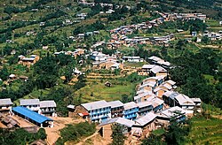 Diktel Rupakot Majhuwagadhi Nagarpalika (Diktel Bazar, Khotang) | |
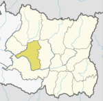
 Diktel Rupakot Majhuwagadhi Nagarpalika Location in Province No. 1  Diktel Rupakot Majhuwagadhi Nagarpalika Diktel Rupakot Majhuwagadhi Nagarpalika (Nepal) | |
| Coordinates: 27°12′50″N86°47′52″E / 27.21389°N 86.79778°E | |
| Country | |
| Province | Province No. 1 |
| District | Khotang |
| Government | |
| • Mayor | Tirtharaj Bhattrai ( (NC)) |
| • Deputy Mayor | Bishan Rai (Maiost) |
| Area | |
• Total | 246.51 km2 (95.18 sq mi) |
| • Rank | 8th (Province No. 1) |
| Highest elevation | 2,250 m (7,380 ft) |
| Lowest elevation | 700 m (2,300 ft) |
| Population (2011) | |
• Total | 46,903 |
| • Density | 190/km2 (490/sq mi) |
| Time zone | UTC+5:45 (NST) |
| Website | official website |

Diktel Rupakot Majhuwagadhi is a Municipality in Khotang District of Province No. 1 of Nepal. The municipality was established in May 2014 merging some the previous Village Development Committees (VDCs) of Bamrang, Laphyang and Kahalle as Diktel Municipality. [1] [2]
Contents
Diktel was renamed to Rupakot Majhuwagadhi on 10 March 2017 after merging some more VDCs. The municipality is divided into 15 wards. It is on 700 m to 2250 m of elevation from sea level. The area of the municipality is 246.51 km2. There are 10,050 households with population of 46,903. [3] [4] By 2020, the name commonly used name Diktel was re-added to the municipality's official name.[ citation needed ]