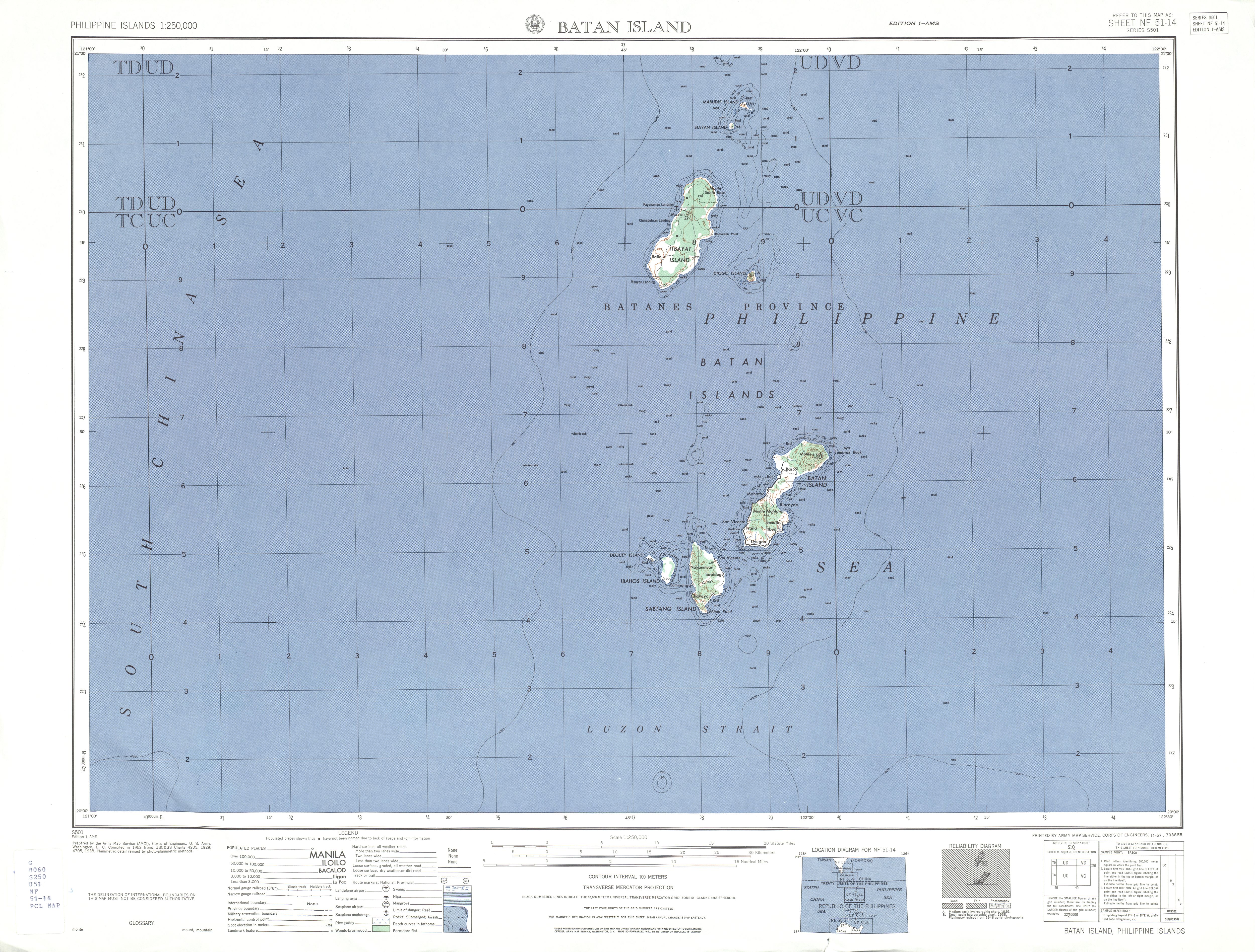
Diogo Island

Last updated
Diogo
Native name:
Inem
Ph locator Diogo.png
Diogo Island
Philippines Batanes relief location map.svg
Red pog.svg
Diogo
Location within Batanes
Philippines relief location map (Luzon).svg
Red pog.svg
Diogo
Location in Luzon
Philippines relief location map (square).svg
Red pog.svg
Diogo
Location in Philippines
Geography
Location Luzon Strait
Coordinates 20°42′8″N121°55′41″E / 20.70222°N 121.92806°E / 20.70222; 121.92806 Coordinates: 20°42′8″N121°55′41″E / 20.70222°N 121.92806°E / 20.70222; 121.92806
Archipelago Batanes Group of Islands
Length1.2 km (0.75 mi)
Width1.2 km (0.75 mi)
Highest elevation547 m (1795 ft) [1]
Highest pointMount Di'nem
Administration
Philippines
Region Cagayan Valley
Province Batanes
Municipality Itbayat
Demographics
Populationuninhabited
Additional information
Official website Batanes Province Official Website

Diogo Island known as Di'nem Island is an uninhabited volcanic island in the province of Batanes, the northernmost province in the Philippines. Also known as Di'nem Island in the native language, [2] Diogo is a lone rock rising out of the sea, with steep cliffs on every side, and dangerous currents make landing there practically impossible. It is an extinct volcano which has suffered heavily from marine erosion. [3]

Contents

Geography

Diogo is a small, round island over 1,795 feet (547 m) high, about 34 mile (1.2 km) in diameter, lying 3.5 miles (5.6 km) southeastward of Itbayat Island. It is steep on the western side but has several small islets lying off the eastern side, the outermost being nearly 12 mile (0.80 km) distant. [4]

Geology

In 1903, Diogo Island was observed to be volcanic, discharging vapor and dark material, but another observation in 1908 believe that those are small clouds which often hang around the mountain. [3] It is listed as an inactive volcano [5] by the Philippine Institute of Volcanology and Seismology.

Previous names

In old Spanish maps, the name of the island was listed as Isla Diego or Rodonta. [6]

See also

Related Research Articles

<span class="mw-page-title-main">Babuyan Islands</span> Island group in the Philippines

The Babuyan Islands, also known as the Babuyan Group of Islands, is an archipelago in the Philippines, located in the Luzon Strait north of the main island of Luzon and south of Taiwan via Bashi Channel to Luzon Strait. The archipelago consists of five major islands and their surrounding smaller islands. These main islands are, counterclockwise starting from northeast, Babuyan, Calayan, Dalupiri, Fuga, and Camiguin. The Babuyan Islands are separated from Luzon by the Babuyan Channel, and from the province of Batanes to the north by the Balintang Channel.

<span class="mw-page-title-main">Mount Pinatubo</span> Active stratovolcano in the Philippines

Mount Pinatubo is an active stratovolcano in the Zambales Mountains, located on the tripoint boundary of the Philippine provinces of Zambales, Tarlac and Pampanga, all in Central Luzon on the northern island of Luzon. Its eruptive history was unknown to most before the pre-eruption volcanic activity of early 1991. Pinatubo was heavily eroded and obscured from view by dense forests which supported a population of several thousand indigenous Aetas.

Didicas Volcano is an active volcanic island in the province of Cagayan in northern Philippines. The island, which was a submarine volcano and re-emerged from the sea in 1952, is 22 kilometres (14 mi) NE of Camiguin Island, one of the Babuyan Islands in Luzon Strait. Before 1952, the volcano first breached the ocean surface in 1857.

<span class="mw-page-title-main">Batan Island</span> Island in Batanes, Philippines

Batan Island is the main island of Batanes, an archipelagic province in the Philippines. It is the second largest of the Batanes Islands, the northernmost group of islands in the country. Four of the six municipalities of Batanes are located on the 20-kilometer (12 mi) long island including the provincial capital of Basco. The other municipalities are Ivana, Mahatao and Uyugan.

<span class="mw-page-title-main">Mount Edgecumbe (Alaska)</span> Mountain in Alaska, United States

Mount Edgecumbe is located at the southern end of Kruzof Island, Alaska, about 15 miles (24 km) west of Sitka. The volcano is about 9.9 miles (16 km) east of the Queen Charlotte Fault that separates the North American and Pacific Plates, and is the highest point in the Mount Edgecumbe volcanic field, an area of about 100 square miles (260 km2) on Kruzof Island that also includes Crater Ridge and Shell Mountain.

<span class="mw-page-title-main">Itbayat</span> Municipality in Cagayan Valley, Philippines

Itbayat, officially the Municipality of Itbayat,, is a 5th class municipality in the province of Batanes, Philippines. According to the 2020 census, it has a population of 3,128 people. 

<span class="mw-page-title-main">Siayan Island</span> Island in Batanes, Philippines

Siayan is one of the Batanes Islands. Also known as Ditarem Island in the native language, the island is about 1/2 mile to 3/4 miles in diameter and lies about 5 miles (8.0 km) north-northeastward of Itbayat Island. The closest island is Mavulis Island which is about 1.5 miles (2.4 km) north-northeastward of Siayan. There are several detached rocks off Siayan's northeast side, rendering the channel between it and Mabudis unsafe for larger vessels.

Camiguin de Babuyanes is an active stratovolcano on Camiguin Island, part of the Babuyan Islands group that is located in Luzon Strait, north of the island of Luzon, in the Philippines. The volcano and the island are within the jurisdiction of the municipality of Calayan, in the province of Cagayan. The island has a population of 5,231 people in 2020. 

<span class="mw-page-title-main">Mount Talinis</span> Complex volcano in the Philippine province of Negros Occidental

Mount Talinis is a complex volcano in the Philippine province of Negros Oriental. At about 1,903 metres (6,243 ft) above sea level, it is the second highest mountain on Negros Island after Mount Kanlaon, and the tallest peak in the mountain range known as the Cuernos de Negros. The volcano is located 9 km (5.6 mi) southwest of the municipality of Valencia; and 20 km (12 mi) from Dumaguete City, the capital of the province.

Dakut is located in the province of Sulu, in the Autonomous Region in Muslim Mindanao, of the Philippines.

Mount Mandalagan is a complex volcano located at latitude 10.65° North (10°39'0"N), longitude 123.25° East (123°15'0"E), in the province of Negros Occidental, on the north of the island of Negros of the Philippines. It is located inside the Northern Negros Natural Park.

Balut Island, also known as Malulong, is a potentially active volcanic island south of the tip of Davao Occidental province in the Mindanao region, southern Philippines. At the center of the island is Balut Volcano, a fumarolic volcano with no historical eruptions.

Dequey is one of the Batanes Islands, in the province of Batanes, in Luzon Strait, the Philippines. The island is a very small and a rather low piece of land, lying nearly 1/2 mile westward of the northwest point of Ivuhos Island. Dequey Island is uninhabited.

Batag Island Lighthouse is a historic lighthouse on Batag Island off the coast of the town of Laoang in the province of Northern Samar in the Philippines. The light marks the northeastern point of Samar Island and lead international ships to the entrance of the San Bernardino Strait marked by the San Bernardino Light. One of the most traveled waterways in the archipelago, together with the Capul Island Light, these stations are invaluable to vessels coming from the Pacific Ocean and entering the country through the San Bernardino Strait on its way to Manila or any other ports of the Philippines.

<span class="mw-page-title-main">Quiniluban Group</span>

The Quiniluban Group is a group of islands in Palawan Province of the Philippines situated between the islands of Palawan and Panay in the Sulu Sea. The group is the northernmost in the Cuyo Archipelago, consisting of several islands and rocks. The easternmost of which is a circular group of islands surrounded by reef about 6 nautical miles in diameter. The largest of the circular group is Quiniluban Island. The island group also includes the upscale resort island of Pamican located about 5.6 nautical miles southwest of the circular group, and Manamoc Island located 3.0 nautical miles further southwest of Pamilacan.

<span class="mw-page-title-main">Ivuhos</span> Island in Batanes, Philippines

Ivuhos is one of the islands of Batanes, the northernmost province of the Philippines. The uninhabited island is located west of Sabtang Island and is separated by a deep channel nearly 2 kilometres (1.2 mi) wide.

<span class="mw-page-title-main">Babuyan Island</span> Island within the Babuyan Islands, the Philippines

Babuyan Island is the highest and northernmost island in the Babuyan Islands in Luzon Strait north of Luzon Island in the Philippines and also directly south of Taiwan via Bashi Channel to Luzon Strait. The whole island makes up the barangay of Babuyan Claro, that constitute the municipality of Calayan in Cagayan province. The volcanic island has a population of 1,910 as of the 2020 census, up from 1,423 in 2010. 

Balintang Islands are a small group of rocky islands in the middle of Balintang Channel, in Luzon Strait, northern Philippines. The islands are almost equidistant to both Babuyan Island, Cagayan, which lies about 29 miles (47 km) to the southwest, and Sabtang Island, Batanes, located 28 miles (45 km) to the northwest. The group is composed of seven small, sharp-peaked islets and rocks visible about 24 miles (39 km) in clear weather. Taiwan will be also directly to the north of Luzon Island in the Philippines via Luzon Strait to Bashi Channel.

<span class="mw-page-title-main">Mount Sungay</span> Volcanic mountain in the Philippines

Mount Sungay, also known as Mount Gonzales, is a mountain in the province of Cavite in the Philippines. Located in eastern Tagaytay, the inactive stratovolcano is the highest point in the province of Cavite, at 709 metres. The slopes of the mountain are the source of the San Cristobal River that flows from the mountain to Silang, Cavite down to its mouth at Laguna de Bay in Calamba, Laguna.

References

  1. U.S. Army Corps of Engineer (1952). "Batan Island Map". University of Texas at Austin Library. Retrieved on 2011-06-05.
  2. University of Georgia, Yami culture of Taiwan Archived 2011-08-07 at the Wayback Machine , Retrieved on 2010-08-24
  3. 1 2 Ferguson, Henry G. (1908-02). "The Philippine Journal of Science, Vol.3 Part 1", p.12. Manila Bureau of Printing, 1908.
  4. U.S. Coast and Geodetic Survey, Department of Commerce. United States Coast Pilot, Philippine Islands Part I, p. 39. Washington Government Printing Office, 1919.
  5. PHILVOCS, List of Inactive Volcanoes in the Philippines . Retrieved on 2010-08-24.
  6. Algué, P. José (1899). Atlas de Filipinas", p. 39. Washington Government Printing Office, 1900.