Signy Island is a small subantarctic island in the South Orkney Islands of Antarctica. It was named by the Norwegian whaler Petter Sørlle (1884–1933) after his wife, Signy Therese.

Thurston Island is an ice-covered, glacially dissected island, 215 km (134 mi) long, 90 km (56 mi) wide and 15,700 km2 (6,062 sq mi) in area, lying a short way off the northwest end of Ellsworth Land, Antarctica. It is the third-largest island of Antarctica, after Alexander Island and Berkner Island.

Booth Island is a rugged, Y-shaped island, 8 kilometres (5 mi) long and rising to 980 m (3,215 ft) off the northwest coast of Kyiv Peninsula in Graham Land, Antarctica in the northeastern part of the Wilhelm Archipelago. The narrow passage between the island and the mainland is the Lemaire Channel.

The Scotia Sea is a sea located at the northern edge of the Southern Ocean at its boundary with the South Atlantic Ocean. It is bounded on the west by the Drake Passage and on the north, east, and south by the Scotia Arc, an undersea ridge and island arc system supporting various islands. The sea sits atop the Scotia Plate. It is named after the expedition ship Scotia. Many icebergs melt there.
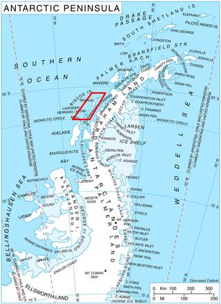
Renaud Island is an ice-covered island in the Biscoe Islands of Antarctica, 40 km (25 mi) long and from 6.4 to 16.1 km wide, lying between the Pitt Islands and Rabot Island. It is separated from the Pitt Islands to the northeast by Mraka Sound, and from Lavoisier Island to the southwest by Pendleton Strait.
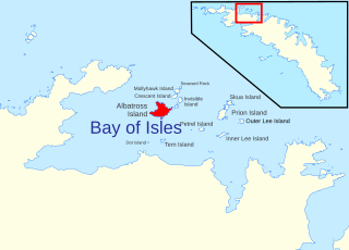
Albatross Island is an island 2 miles (3 km) southeast of Cape Buller, lying in the Bay of Isles, South Georgia. Charted in 1912–13 by Robert Cushman Murphy, American naturalist aboard the brig Daisy, who gave this name because he observed albatrosses there. The eastern headland of the island is called The Pricker, a name which first appeared on a 1931 British Admiralty chart.

King Haakon Bay, or King Haakon Sound, is an inlet on the southern coast of the island of South Georgia. The inlet is approximately 13 km long and 4 km wide. The inlet was named for King Haakon VII of Norway by Carl Anton Larsen, founder of Grytviken. Queen Maud Bay, named for his queen, is nearby. Shackleton Gap, a mountain pass, connects King Haakon Bay to Possession Bay.

The Willis Islands are a small archipelago to the west of South Georgia Island in the South Georgia Islands. They are 2 miles (3.2 km) west of Bird Island, separated by the Stewart Strait. They were discovered on 14 January 1775 by Captain James Cook and named for Cook's midshipman Thomas Willis, the crew member who first sighted them. The Willis Islands were charted in greater detail and individually named by Discovery Investigations (DI) personnel between 1926-1930.

Annenkov Island is to the west of the main island of South Georgia. The Pickersgill Islands are to its southeast. It is irregularly shaped and 4 miles (6.4 km) long and 650 m (2,130 ft) high, lying 8 miles (13 km) off the south-central coast of South Georgia.
Prion Island is an island 2.4 km (1.5 mi) north-northeast of Luck Point, lying in the Bay of Isles, South Georgia. It was charted in 1912-13 by Robert Cushman Murphy, American naturalist aboard the brig Daisy, and so named because he observed prions on the island.
Mollyhawk Island is a small, tussock-covered island lying between Seaward Rock and Crescent Island in the northern part of the Bay of Isles, South Georgia. It was charted in 1912–13 by Robert Cushman Murphy, an American naturalist aboard the brig Daisy. The island was surveyed in 1929–30 by Discovery Investigations personnel and named in association with Albatross Island, Prion Island and other natural history names in the Bay of Isles given by Murphy, "mollyhawk" being a name for a type of young gull.

The Bay of Isles is a bay 9 miles (14 km) wide and receding 3 miles (5 km), lying between Cape Buller and Cape Wilson along the north coast of South Georgia. It was discovered in 1775 by a British expedition under James Cook and so named by him because numerous islands lie in the bay. Of South Georgia's 31 breeding bird species, 17 are found here.
Gony Point is a high tussock-covered point 0.5 miles (0.8 km) southwest of Cardno Point, on the southeast side of Bird Island, South Georgia. It was surveyed by the South Georgia Survey in the period 1951–57, and named by the UK Antarctic Place-Names Committee in 1963. Gony is an old sailors' name for the wandering albatross, which breeds on Bird Island.
Skua Island is an island immediately northeast of Prion Island in the entrance to the Bay of Isles, South Georgia. Charted in 1912-13 by Robert Cushman Murphy, American naturalist aboard the brig Daisy. Surveyed in 1929-30 by DI personnel and named in association with Albatross Island, Prion Island and other natural history names given in the Bay of Isles by Murphy in 1912–13.

Larsen Harbour is a narrow 2.6 miles (4.2 km) long inlet of indenting volcanic rocks and sheeted dykes known as the Larsen Harbour Formation. It is a branch of Drygalski Fjord, entered 2.5 miles (4 km) west-northwest of Nattriss Head, at the southeast end of South Georgia Island. It was charted by the Second German Antarctic Expedition, 1911–12, under Filchner, who named it for Captain Carl Anton Larsen a Norwegian explorer, who made significant contributions to the exploration of Antarctica. The most significant of these was the first discovery of fossils on the continent, for which he received the Back Grant from the Royal Geographical Society. Larsen is also considered the founder of the Antarctic whaling industry and the settlement and whaling station of Grytviken, South Georgia.
Bogen Glacier is a small glacier on the north side of Drygalski Fjord between Trendall Crag and Hamilton Bay, at the southeast end of South Georgia. It was named by the UK Antarctic Place-Names Committee in 1979 after Arne Bogen, Norwegian sealer working in South Georgia after 1950; Master of the sealing vessel Albatross and Station Foreman, Grytviken.
Wanderer Valley is a valley in central Bird Island, South Georgia. The valley extends northeast for 0.5 nautical miles (0.9 km) from the head of Freshwater Inlet. It was named by the United Kingdom Antarctic Place-Names Committee (UK-APC) after the wandering albatross whose principal breeding grounds are nearby.
Pio Point is a point forming the north side of the entrance to Johnson Cove at the west end of Bird Island, South Georgia. Roughly charted by DI personnel on the Discovery in the period 1926-30 and surveyed by HMS Owen in 1960–61. Named by the United Kingdom Antarctic Place-Names Committee (UK-APC) in 1963. "Pio" is an old sailors' name for the light-mantled sooty albatross, a bird which breeds on Bird Island.
Molly Hill is a hill between Evermann Cove and Johnson Cove on western Bird Island, South Georgia, an island in the southern Atlantic Ocean. The name derives from the black-browed albatross or "mollymawk" which breeds on the hill in large numbers. According to the UK Antarctic Place-Names Committee, the name has been in local usage since at least 1963.
The Henkes Islands are a group of small islands and rocks 4 kilometres (2 nmi) in extent, lying 2 kilometres (1 nmi) southwest of Avian Island, close off the southern extremity of Adelaide Island, Antarctica. The islands were discovered by the French Antarctic Expedition, 1908–10, under Jean-Baptiste Charcot, and named by him for one of the Dutch directors of the Magellan Whaling Company at Punta Arenas. Charcot applied the name to the scattered rocks and islands between Cape Adriasola and Cape Alexandra, and the name was restricted to the group described by the UK Antarctic Place-Names Committee (UKAPC) following definitive mapping by the British Antarctic Survey (BAS) in 1961 and the British Royal Navy Hydrographic Survey (BRNHS) in 1963. All of the islands in the group were named by UKAPC.
