
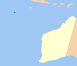
The Cocos (Keeling) Islands, officially the Territory of Cocos (Keeling) Islands, are an Australian external territory in the Indian Ocean, comprising a small archipelago approximately midway between Australia and Sri Lanka and relatively close to the Indonesian island of Sumatra. The territory's dual name reflects that the islands have historically been known as either the Cocos Islands or the Keeling Islands.

Cockatoo Island is a UNESCO World Heritage Site at the junction of the Parramatta and Lane Cove River in Sydney Harbour, New South Wales, Australia.

Emirau Island, also called Emira, is an island in the Bismarck Archipelago located at 1°38.5′S149°58.5′E. It is currently part of the New Ireland Province of Papua New Guinea. The local language is a dialect of the Mussau-Emira language. Emira is part of what on many maps are charted as the St Matthias Islands, also known as the Mussau Islands, a small group to the north-west of the main-island group of New Ireland. Early explorers named it Squally Island, a name still found in some early records.

Belmore is a suburb of Sydney, in the state of New South Wales, Australia. Belmore is located 11 kilometres south-west of the Sydney central business district, in the local government area of the City of Canterbury-Bankstown.

The Cockatoo Island Dockyard was a major dockyard in Sydney, Australia, based on Cockatoo Island. The dockyard was established in 1857 to maintain Royal Navy warships. It later built and repaired military and battle ships, and played a key role in sustaining the Royal Australian Navy. The dockyard was closed in 1991, and its remnants are heritage listed as the Cockatoo Island Industrial Conservation Area.
Direction Island may refer to:

The Australian Indian Ocean Territories is the name since 1995 of an administrative unit under the Australian Department of Infrastructure, Transport, Regional Development, Communications and the Arts, consisting of two island groups in the Indian Ocean under Australian sovereignty:
The Shire of Cocos (Keeling) Islands is a local government area which manages local affairs on the Australian external territory of Cocos (Keeling) Islands. The island is grouped with Western Australia but is administered by the Department of Infrastructure, Regional Development and Cities and an Administrator.
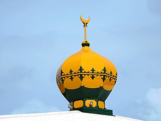
Islam in the Cocos (Keeling) Islands is the majority religion. As of the 2016 census, 75% of the population were Muslim.

West Island, part of the South Keeling Islands, is the capital of the Cocos (Keeling) Islands, an Australian external territory in the Indian Ocean. The population is roughly 120, making it the third smallest capital in the world, and consists mainly of Europeans. It is less populous than Home Island, the only other inhabited island.

North Keeling is a small, uninhabited coral atoll, approximately 1.2 square kilometres (0.46 sq mi) in area, about 25 kilometres (16 mi) north of Horsburgh Island. It is the northernmost atoll and island of the Australian territory of the Cocos (Keeling) Islands. It consists of just one C-shaped island, a nearly closed atoll ring with a small opening into the lagoon, about 50 metres (160 ft) wide, on the east side. The lagoon is about 0.5 square kilometres (0.19 sq mi) in area. The island is home to the only surviving population of the endemic, and endangered, Cocos buff-banded rail, as well as large breeding colonies of seabirds. Since 1995, North Keeling Island and the surrounding sea to 1.5 kilometres (0.93 mi) from shore have been within the Pulu Keeling National Park.

Horsburgh Island is one of the Cocos (Keeling) Islands. Its area is 1.04 square kilometres. There is a small lagoon in the interior of the island to the northeast.

Home Island, also known locally as Pulu Selma, is one of only two permanently inhabited islands of the 26 islands of the Southern Atoll of the Cocos (Keeling) Islands, an Australian external territory in the central-eastern Indian Ocean.

Careening Cove, is a bay on the northern side of Sydney Harbour, near Milsons Point. The cove lies in the traditional lands of the Cammeraygal people, who called it Wia Wia. It was later named for its use in the early days of European settlement in Australia, careening.

Cockatoo Island Industrial Conservation Area is a heritage-listed protected area relating to the former Cockatoo Island Dockyard at Cockatoo Island, Sydney Harbour, New South Wales, Australia. It was added to the Australian Commonwealth Heritage List on 22 June 2004.
The Home Island Industrial Precinct is a heritage-listed industrial area at Jalan Bunga Mawar, Home Island, Cocos (Keeling) Islands, Australia. It was added to the Australian Commonwealth Heritage List on 22 June 2004.
The Direction Island Slipway and Tank are heritage-listed industrial remnants at Direction Island, Cocos (Keeling) Islands, Australia. The site was added to the Australian Commonwealth Heritage List on 22 June 2004.
The Old Co-op Shop is a heritage-listed retail building at Jalan Bunga Mawar, Home Island, Cocos (Keeling) Islands, Australia. It was added to the Australian Commonwealth Heritage List on 22 June 2004.

Malay Kampong Group is a heritage-listed Malay precinct at Jalan Panyai, Flying Fish Cove in the Australian territory of Christmas Island. It was added to the Australian Commonwealth Heritage List on 22 June 2004.

Pulu Cocos Museum, also Home Island Visitor Centre & Museum, also Cocos Museum, is a tourism office, visitor centre and museum on Home Island in the Cocos (Keeling) Islands.
