The Trans-Canada Highway is a transcontinental federal–provincial highway system that travels through all ten provinces of Canada, from the Pacific Ocean on the west coast to the Atlantic Ocean on the east coast. The main route spans 7,476 km (4,645 mi) across the country, one of the longest routes of its type in the world. The highway system is recognizable by its distinctive white-on-green maple leaf route markers, although there are small variations in the markers in some provinces.
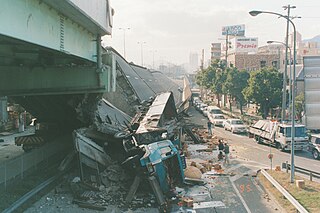
The Great Hanshin Earthquake occurred on January 17, 1995, at 05:46:53 JST in the southern part of Hyōgo Prefecture, Japan, including the region known as Hanshin. It measured 6.9 on the moment magnitude scale and had a maximum intensity of 7 on the JMA Seismic Intensity Scale. The tremors lasted for approximately 20 seconds. The focus of the earthquake was located 17 km beneath its epicenter, on the northern end of Awaji Island, 20 km away from the center of the city of Kobe.

Abbotsford is a city located in British Columbia, next to the Canada–United States border, Greater Vancouver and the Fraser River. With a census population of 153,569 people (2021), it is the largest municipality in the province outside metropolitan Vancouver. Abbotsford–Mission has the third-highest proportion of visible minorities among census metropolitan areas in Canada, after the Greater Toronto Area and the Greater Vancouver CMA. It is home to Tradex, the University of the Fraser Valley, and Abbotsford International Airport.

5-1-1 is a transportation and traffic information telephone hotline in some regions of the United States and Canada. Travelers can dial 511, a three-digit telephone number, on landlines and most mobile phones. The number has also extended to be the default name of many state and provincial transportation department road conditions Web sites, such as Wisconsin's site. It is an example of an N11 code, part of the North American Numbering Plan.
Highway 1 is a provincial highway in British Columbia, Canada, that carries the main route of the Trans-Canada Highway (TCH). The highway is 1,047 kilometres (651 mi) long and connects Vancouver Island, the Greater Vancouver region in the Lower Mainland, and the Interior. It is the westernmost portion of the main TCH to be numbered "Highway 1", which continues through Western Canada and extends to the Manitoba–Ontario boundary. The section of Highway 1 in the Lower Mainland is the second-busiest freeway in Canada, after Ontario Highway 401 in Toronto.
There are many roads in the southwestern part of British Columbia and Vancouver Island that were designated as Highway 1A. These roads were sections of the original 1941 route of Highway 1 before its various re-alignments, and are used today as service routes and frontage roads. The "B.C. Highway 1A" designations were removed from these sections by the province between 2005 and 2010, although signage remains along some of the route and the designation on some maps.
Highway 11, known locally as the Abbotsford-Mission Highway, is a 17 km (11 mi) long at-grade expressway that figuratively cuts the Fraser Valley in half. The highway was first given the '11' designation in 1958, and it originally followed South Fraser Way through Abbotsford, being re-routed onto the four-lane Sumas Way in the mid-1980s. Highway 11 originally entered Mission over the same bridge that carries a spur of the Canadian Pacific Railway across the Fraser River, but it was re-routed onto its own bridge, the Mission Bridge, in 1973.
Highway 5 is a 543 km (337 mi) north–south route in southern British Columbia, Canada. Highway 5 connects the southern Trans-Canada route with the northern Trans-Canada/Yellowhead route, providing the shortest land connection between Vancouver and Edmonton. Despite the entire route being signed as part of the Yellowhead Highway, the portion of Highway 5 south of Kamloops is also known as the Coquihalla Highway while the northern portion is known as the Southern Yellowhead Highway. The Coquihalla section was a toll road until 2008.
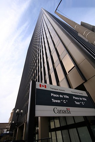
Transport Canada is the department within the Government of Canada responsible for developing regulations, policies and services of road, rail, marine and air transportation in Canada. It is part of the Transportation, Infrastructure and Communities (TIC) portfolio. The current Minister of Transport is Pablo Rodriguez. Transport Canada is headquartered in Ottawa, Ontario.

Alberta Provincial Highway No. 3, commonly referred to as Highway 3 and officially named the Crowsnest Highway, is a 324-kilometre (201 mi) highway that traverses southern Alberta, Canada, running from the Crowsnest Pass through Lethbridge to the Trans-Canada Highway in Medicine Hat. Together with British Columbia Highway 3 which begins in Hope, it forms an interprovincial route that serves as an alternate to the Trans-Canada from the Lower Mainland to the Canadian Prairies.

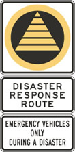
Disaster response refers to the actions taken directly before, during or in the immediate aftermath of a disaster. The objective is to save lives, ensure health and safety and to meet the subsistence needs of the people affected. This includes warning/evacuation, search and rescue, providing immediate assistance, assessing damage, continuing assistance and the immediate restoration or construction of infrastructure. The aim of emergency response is to provide immediate assistance to maintain life, improve health and support the morale of the affected population. Such assistance may range from providing specific but limited aid, such as assisting refugees with transport, temporary shelter, and food to establishing semi-permanent settlements in camps and other locations. It also may involve initial repairs to damage or diversion to infrastructure.

The British Columbia Ambulance Service (BCAS) is an ambulance service that provides emergency medical response for the province of British Columbia, Canada. BCAS is one of the largest providers of emergency medical services in North America. The fleet consists of more than 500 ground ambulances operating from 183 stations across the province along with 80 support vehicles. Additionally, BCAS provides inter-facility patient transfer services in circumstances where a patient needs to be moved between health care facilities for treatment. BCAS also operates a medical evacuation program that utilizes both fixed-wing and rotary aircraft.

MV Queen of the North was a roll-on/roll-off (RORO) ferry built by AG Weser of Germany and operated by BC Ferries, which ran along an 18-hour route along the British Columbia Coast of Canada between Port Hardy and Prince Rupert, British Columbia, a route also known as the Inside Passage. On March 22, 2006, with 101 people aboard, she failed to make a planned course change, ran aground and sank. Two passengers, whose bodies were never found, died in the incident. The ship had a gross register tonnage of 8,806, and an overall length of 125 metres (410 ft). She had a capacity of 700 passengers and 115 cars.
The Ministry of Emergency Management and Climate Readiness (EMCR), formerly Emergency Management BC (EMBC), is a provincial government department in the Canadian province of British Columbia. EMCR works with local governments and other provincial and federal agencies year round, providing coordination and support before, during and after emergencies. EMCR is administered under the Emergency Program Act.
The 400-series highways were a pair of controlled-access highways located in the southwestern portion of the Canadian province of British Columbia, forming a special subset of the provincial highway system. Modelled after the 400-Series Highways in Ontario, 400-series designations were introduced in 1964 in conjunction with the completion of the Trans-Canada Highway freeway between Vancouver and Clearbrook ; however, unlike their Ontario counterparts, both routes had signalized sections. The 400-series system never expanded beyond two freeways, and in 1973 Highways 401 and 499 were renumbered 1 and 99 respectively, while the former routes were assigned the 'A' suffix.
Road signs in Canada may conform to the Manual of Uniform Traffic Control Devices for Canada (MUTCDC) by the Transportation Association of Canada (TAC) for use by Canadian jurisdictions. Although it serves a similar role to the MUTCD from the US Federal Highway Administration, it has been independently developed and has a number of key differences with its American counterpart, most notably the inclusion of bilingual (English/French) signage for jurisdictions such as New Brunswick with significant anglophone and francophone population, and a heavier reliance on symbols rather than text legends.
The Office of U.S. Foreign Disaster Assistance (OFDA) was an organizational unit within the United States Agency for International Development (USAID) charged by the President of the United States with directing and coordinating international United States government disaster assistance. USAID merged the former offices of OFDA and Food for Peace (FFP) in 2020 to form the Bureau for Humanitarian Assistance (BHA).

Terminology related to road transport—the transport of passengers or goods on paved routes between places—is diverse, with variation between dialects of English. There may also be regional differences within a single country, and some terms differ based on the side of the road traffic drives on. This glossary is an alphabetical listing of road transport terms.
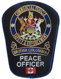
British Columbia Commercial Vehicle Safety & Enforcement is a provincial law enforcement agency that is responsible for the compliance and enforcement of the commercial transport sector, protection of the environment and transportation infrastructure of British Columbia, increasing road safety and protecting the motoring public.

The 2021 Pacific Northwest floods were a series of floods that affected British Columbia, Canada, and parts of neighboring Washington state in the United States. The flooding and numerous mass wasting events were caused by a Pineapple Express, a type of atmospheric river, which brought heavy rain to parts of southern British Columbia and northwestern United States. The natural disaster prompted a state of emergency for the province of British Columbia.