
Tunis is the capital and largest city of Tunisia. The greater metropolitan area of Tunis, often referred to as "Grand Tunis", has about 2,700,000 inhabitants. As of 2020, it is the third-largest city in the Maghreb region and the eleventh-largest in the Arab world.

The Battle of Kasserine Pass took place from 18-24 February 1943 at Kasserine Pass, a 2-mile-wide (3.2 km) gap in the Grand Dorsal chain of the Atlas Mountains in west central Tunisia. It was a part of the Tunisian campaign of World War II.

The Tunisian campaign was a series of battles that took place in Tunisia during the North African campaign of the Second World War, between Axis and Allied forces from 17 November 1942 to 13 May 1943. The Allies consisted of British Imperial Forces, including a Greek contingent, with American and French corps. The battle opened with initial success by the German and Italian forces but the massive supply interdiction efforts led to the decisive defeat of the Axis. Over 250,000 German and Italian troops were taken as prisoners of war, including most of the Afrika Korps.

The 334th Infantry Division was a German Army infantry division in World War II. Originally formed in November 1942, it surrendered to the Allies at the conclusion of the Tunisian Campaign in May 1943. The division was reconstituted on 3 June 1943 in France within the 1st Army, with the staff of the 80th Infantry Division as well as remnants of the old division and replacement units. It spent the remainder of the war serving on the Italian Front.

The Mareth Line was a system of fortifications built by France in southern Tunisia in the late 1930s. The line was intended to protect Tunisia against an Italian invasion from its colony in Libya. The line occupied a point where the routes into Tunisia from the south converged, leading toward Mareth, with the Mediterranean Sea to the east and mountains and a sand sea to the west.

Jebel ech Chambi is a mountain peak in Tunisia. It has an elevation of 1,544 m (5,066 ft) and is the highest mountain in the country. It stands above the city of Kasserine in western central Tunisia. The summit is covered by a pine forest and is part of Chambi National Park.

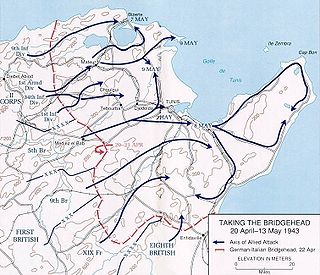
Operation Vulcan and Operation Strike were the final ground attacks by the Allied forces against the Italian and German forces in Tunis, Cape Bon, and Bizerte, the last Axis toeholds in North Africa, during the Tunisian campaign of the Second World War.
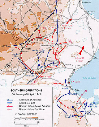
The Battle of Sidi Bou Zid(Unternehmen Frühlingswind/Operation Spring Breeze) took place during the Tunisia Campaign from 14–17 February 1943, in World War II. The battle was fought around Sidi Bou Zid, where a large number of US Army units were mauled by German and Italian forces. It resulted in the Axis forces recapturing the strategically important town of Sbeitla in central Tunisia.
Sedjenane is a town in northern Tunisia, on the railway line to Mateur and the port of Bizerta. The Battle of Sedjenane was fought during World War II between the Allies and Axis for control of a town in northern Tunisia, on the railway line to Mateur and the port of Bizerta. The battle was part of the Tunisia Campaign.

The following outline is provided as an overview of and topical guide to Tunisia:
Division von Broich was a German provisional infantry division active in 1942–43 in North Africa. It was created in November 1942 and named after its notable commander Friedrich von Broich. In February 1943, the division was renamed Division von Manteuffel after its new commander, Generalmajor Hasso von Manteuffel. Despite its makeshift nature, the unit proved itself as a capable force, taking part in numerous actions until forced to capitulate with the rest of Army Group Africa in May 1943.
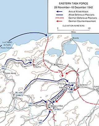
The Run for Tunis was part of the Tunisia Campaign which took place during November and December 1942 during the Second World War. Once French opposition to the Allied Operation Torch landings had ceased in mid-November, the Allies made a rapid advance by a division-sized force east from Algeria, to capture Tunis and forestall an Axis build up in Tunisia and narrowly failed. Some Allied troops were fewer than 20 miles (32 km) short of Tunis by late November but the defenders counter-attacked and pushed them back nearly 20 miles (32 km), to positions which had stabilised by the end of the year.

Jebel Boukornine, also spelled Djebel Bou Kornine or Mount Bou Kornine, is a 576-meter mountain in northern Tunisia, overlooking the Gulf of Tunis and Hammam Lif city.
The Battle of Wadi Akarit was an Allied attack from 6 to 7 April 1943, to dislodge Axis forces from positions along the Wadi Akarit in Tunisia during the Tunisia Campaign of the Second World War. The Gabès Gap, north of the towns of Gabès and El Hamma, is a passage between the sea and impassable salt marshes. The 51st (Highland) Infantry Division breached the defences and held a bridgehead, allowing the passage of their main force to roll up the Axis defences. After several determined counter-attacks, the Axis forces withdrew and the Eighth Army, under General Bernard Montgomery, pursued toward Tunis, until reaching Axis defensive positions at Enfidaville.
Tunisia, officially the Tunisian Republic, is the northernmost country in Africa. It is a Maghreb country and is bordered by Algeria to the west, Libya to the southeast, and the Mediterranean Sea to the north and east. Its area is almost 165,000 square kilometres (64,000 sq mi), with an estimated population of just over 10.4 million. Its name is derived from the capital Tunis located in the north-east.
The Battle of Hill 609 took place at Djebel Tahent in northwestern Tunisia during the Tunisian campaign of World War II. The battle was for control over the key strategic height Hill 609 and its surrounding area between the American forces of the U.S. II Corps and German units of the Afrika Korps. The battle proved a formative experience for the American forces - in their first clear-cut victory of the campaign, and has been called "the American Army's coming-of-age."

The 2nd Battle of Longstop Hill or the Capture of Longstop Hill took place in Tunisia during the Tunisia Campaign of World War II from 21 to 23 April 1943. The battle was fought for control over the heights of Djebel el Ahmera and Djebel Rhar, together known as Longstop Hill and vicinity, between the British forces of the First Army and German units of the 5th Panzer Army. The infantry of the 78th Battleaxe Division and Churchill tanks of the North Irish Horse captured Longstop Hill after bitter fighting, in which the tanks created a measure of tactical surprise by driving up the hill, a manoeuvre that only Churchill tanks could achieve. The attackers broke through the German defences, which were the last great natural barrier on the road to Tunis.

The Belezma Range, also transliterated as Belzma, is a prolongation of the Aurès Mountains, at the confluence of the Tell Atlas and the Saharan Atlas in northeastern Algeria. It is separated from the main Aurès Range by the Batna-El Kantara basin.

The Société du Djebel-Djérissa (SDD) is a Tunisian iron ore mining company founded in 1899 that began operations in 1907. It produced up to 700,000 tons per year of hematite ore in the years before World War II. Production dropped during the war. The company was nationalized in 1961. Today levels of output are around 200,000 tons annually.
The geology of Tunisia is defined by the tectonics of North Africa, with large highlands like the Atlas Mountains as well as basins such as the Tunisian Trough. Geologists have identified rock units in the country as much as a quarter-billion years old, although most units date to the Mesozoic and Cenozoic, in the past 250 million years. Tunisia has a small but active mining industry and a significant oil and natural gas sector.


