Lotus Island is a 0.2-mile-long (320 m) island in the Aleutian Islands chain of the U.S. state of Alaska. Located at 52°43′55″N174°03′55″E in the Semichi Islands group of the Near Islands, it is the least prominent of the two islands in Shemya Pass, which separates Nizki and Shemya islands. "Lotus" is also the name of an island in the Odyssey.

Wieck is a village in the administrative district of Gmina Czersk, within Chojnice County, Pomeranian Voivodeship, in northern Poland. It lies approximately 12 kilometres (7 mi) north-east of Czersk, 40 km (25 mi) north-east of Chojnice, and 66 km (41 mi) south-west of the regional capital Gdańsk.
Łosiny is a village in the administrative district of Gmina Tuchola, within Tuchola County, Kuyavian-Pomeranian Voivodeship, in north-central Poland. It lies approximately 17 kilometres (11 mi) north of Tuchola and 70 km (43 mi) north of Bydgoszcz.
Kępa-Kolonia is a village in the administrative district of Gmina Borzechów, within Lublin County, Lublin Voivodeship, in eastern Poland.
Podgórze is a settlement in the administrative district of Gmina Bakałarzewo, within Suwałki County, Podlaskie Voivodeship, in north-eastern Poland. It lies approximately 8 kilometres (5 mi) north-east of Bakałarzewo, 14 km (9 mi) west of Suwałki, and 116 km (72 mi) north of the regional capital Białystok.

Zəfəran is a village in Baku, Azerbaijan.
Cəmilli is a village in the Kalbajar Rayon of Azerbaijan.
Gąsocin is a village in the administrative district of Gmina Sońsk, within Ciechanów County, Masovian Voivodeship, in east-central Poland. It lies approximately 5 kilometres (3 mi) south of Sońsk, 15 km (9 mi) south of Ciechanów, and 62 km (39 mi) north of Warsaw.

Radonie is a village in the administrative district of Gmina Grodzisk Mazowiecki, within Grodzisk Mazowiecki County, Masovian Voivodeship, in east-central Poland. It lies approximately 6 kilometres (4 mi) south of Grodzisk Mazowiecki and 30 km (19 mi) south-west of Warsaw.
Czarnowąż is a village in the administrative district of Gmina Kotuń, within Siedlce County, Masovian Voivodeship, in east-central Poland.
Buda is a village in the administrative district of Gmina Stare Babice, within Warsaw West County, Masovian Voivodeship, in east-central Poland. It lies approximately 9 kilometres (6 mi) north-west of Stare Babice, 10 km (6 mi) north-west of Ożarów Mazowiecki, and 20 km (12 mi) north-west of Warsaw.
Okunino is a village in Gmina Miastko, Bytów County, Pomeranian Voivodeship, in northern Poland. It lies approximately 22 kilometres (14 mi) south-west of Bytów and 71 km (44 mi) south-west of Gdańsk.
Piławki is a settlement in the administrative district of Gmina Miłomłyn, within Ostróda County, Warmian-Masurian Voivodeship, in northern Poland. It lies approximately 6 kilometres (4 mi) south-east of Miłomłyn, 7 km (4 mi) north-west of Ostróda, and 40 km (25 mi) west of the regional capital Olsztyn.

Dřínov is a village and municipality in Kladno District in the Central Bohemian Region of the Czech Republic.
Semmelberg is a hill of Brandenburg, Germany.
Lõpi is a village in Saaremaa Parish, Saare County in western Estonia.
Gepatschspeicher is a lake of Tyrol, Austria.
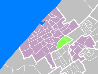
Laak is district of The Hague, Netherlands. With a population of 40,222 and an area of 4.3 square kilometres (1.7 sq mi), it is the smallest and least populous of the city's eight districts. The district is officially divided into three neighbourhoods: Laakkwartier, Spoorwijk and Binckhorst. The Hague University of Applied Sciences can be found in Laak.
Sakhvid Rural District is a rural district (dehestan) in Nir District, Taft County, Yazd Province, Iran. At the 2006 census, its population was 1,747, in 565 families. The rural district has 36 villages.
Chlewiska is a village in the administrative district of Gmina Kotuń, within Siedlce County, Masovian Voivodeship, in east-central Poland.


