Coqueiros do Sul is a municipality in the state of Rio Grande do Sul, Brazil.
Naivela is a town and union council of Dera Ismail Khan District in Khyber Pakhtunkhwa province of Pakistan. It is located at 31°37'52N 70°46'58E and has an altitude of 151 metres.
Teodorówka is a village in the administrative district of Gmina Biłgoraj, within Biłgoraj County, Lublin Voivodeship, in eastern Poland.

Stary Waliszew is a village in the administrative district of Gmina Bielawy, within Łowicz County, Łódź Voivodeship, in central Poland. It lies approximately 4 kilometres (2 mi) south of Bielawy, 22 km (14 mi) west of Łowicz, and 31 km (19 mi) north of the regional capital Łódź.

Ashagy Karashanly is a village in the Kalbajar Rayon of Azerbaijan.
Solquca is a village in the Qabala Rayon of Azerbaijan. The village is part of the municipality of Mıxlıqovaq.
Aşağı Oratağ is a village in the Tartar Rayon of Azerbaijan.

Dorotka is a village in the administrative district of Gmina Tarłów, within Opatów County, Świętokrzyskie Voivodeship, in south-central Poland. It lies approximately 5 kilometres (3 mi) east of Tarłów, 34 km (21 mi) north-east of Opatów, and 83 km (52 mi) east of the regional capital Kielce.
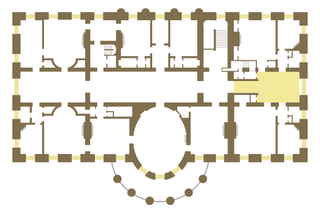
The East Sitting Hall is located on the second floor of the White House, home of the President of the United States. First used as a reception room for guests of the president, it is now a family parlor with access to the east rooms on the second floor.
Paulin is a settlement in the administrative district of Gmina Warka, within Grójec County, Masovian Voivodeship, in east-central Poland.
Murawskie-Czachy is a village in the administrative district of Gmina Boguty-Pianki, within Ostrów Mazowiecka County, Masovian Voivodeship, in east-central Poland. It lies approximately 6 kilometres (4 mi) north of Boguty-Pianki, 34 km (21 mi) east of Ostrów Mazowiecka, and 114 km (71 mi) north-east of Warsaw.
Zawisty-Dworaki is a village in the administrative district of Gmina Boguty-Pianki, within Ostrów Mazowiecka County, Masovian Voivodeship, in east-central Poland. It lies approximately 6 kilometres (4 mi) north of Boguty-Pianki, 36 km (22 mi) east of Ostrów Mazowiecka, and 115 km (71 mi) north-east of Warsaw.
Parzewnia is a settlement in the administrative district of Gmina Żerków, within Jarocin County, Greater Poland Voivodeship, in west-central Poland. It lies approximately 4 kilometres (2 mi) south-west of Żerków, 9 km (6 mi) north of Jarocin, and 59 km (37 mi) south-east of the regional capital Poznań.
Kokczyn Drugi is a village in the administrative district of Gmina Strzałkowo, within Słupca County, Greater Poland Voivodeship, in west-central Poland. It lies approximately 8 kilometres (5 mi) north of Strzałkowo, 10 km (6 mi) north-west of Słupca, and 59 km (37 mi) east of the regional capital Poznań.
Gozdów is a village in the administrative district of Gmina Tuliszków, within Turek County, Greater Poland Voivodeship, in west-central Poland. It lies approximately 7 kilometres (4 mi) south-east of Tuliszków, 10 km (6 mi) west of Turek, and 107 km (66 mi) east of the regional capital Poznań.
Gniewskie Pole is a village in the administrative district of Gmina Kwidzyn, within Kwidzyn County, Pomeranian Voivodeship, in northern Poland. It lies approximately 7 kilometres (4 mi) north-west of Kwidzyn and 67 km (42 mi) south of the regional capital Gdańsk.
Pękaninko is a village in the administrative district of Gmina Białogard, within Białogard County, West Pomeranian Voivodeship, in north-western Poland. It lies approximately 5 kilometres (3 mi) north of Białogard and 116 km (72 mi) north-east of the regional capital Szczecin.
Wierzchęcino is a settlement in the administrative district of Gmina Nowogard, within Goleniów County, West Pomeranian Voivodeship, in north-western Poland.
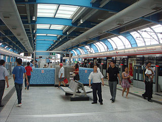
Qinghu station is the terminus station on Line 4 of the Shenzhen Metro and Lines 1 and 2 of the Shenzhen Tram. The station opened on 16 June 2011. It is located in Longhua Town, Shenzhen, Guangdong Province, China.


