Dodamarg Taluka is situated between latitudes 15° 37' N and 15° 60' north and longitudes 73° 19' E and 73° 40' east. It is bordered by the Goa state to the south and west, Karnataka to the southeast and Sahyadri range to the east with a total area of 45053 hectares. Dodamarg is the smallest taluka in Sindhudurg district. According to the census of 2001, the taluka has 53 villages. Both Marathi and Malwani are widely spoken. Marathi is, however, the official language of the Dodamarg. Sex ratio in Dodamarg is 1054 i.e. for each 1000 males, which is below national average of 940 as per census 2011. Literacy rate in Dodamarg is 76.3%. Population of Dodamarg taluka is 50,032 persons as per latest[when?] provisional figures released by directorate of census operation in Sindhudurg, which shows a decrease of 2.30 percent in 2011 compared to figures of 2001 census. Dodamarg is a hilly region broken by valleys and surrounded by mountains.
The main rivers flowing across the taluka is Tilari. Tilari dam is constructed on this river. Kalne river is one of the tributary of this river.
There is a village named Mangeli at the eastern end Dodamarg taluka as well as on the border of Karnataka state. There are viewing points at Unneyi Bandharam, inter-state project of Tilari Dam, Rock Garden, the fort of Pargad and Hunumant Gad, Tervan Medhe, Kasainath Hill, Devotional places of faith like Nagnath Temple and elsewhere. The interstate dam project taken up under the auspices of Irrigation Dept. of Goa and Maharashtra State Govt. The Dam is constructed on Tilari river in Dodamarg Taluka. There is a large lake or reservoir formed by the Tilari Dam. Now-a-days,[when?] a number of wild elephants take shelter in the surroundings of Tilari. The dam and the lake at the distance of 45km from Goa State, attract tourists as well as observers.[citation needed] The Wirdi fall in Dodamarg Taluka is so far an untouched site, at the distance of 20km from Dodamarg Taluka place.
For the last 10 to 15 years,[when?] people from Kerala have done deep study of land, water, and environment of this area and started plantation of Pineapples along with Banana. Now pineapple is one of the main products of taluka. Recent years elephants are also marking entry into Dodamarg taluka from Karnataka state through Khanapur jungle. This is the first time, elephants have found habitation in Maharashtra State. Tilari major irrigation project area (Dodamarg Taluka) is the main habitat. People of dodamarg Also planting the pineapple and banana and sell it to the Mumbai or local market including North Goa.
Places of interest
The Pargad Fort was built by Chatrapati Shivaji Maharaj in 1674 to 1676 AD, on adjoining borders of Kolhapur and Sindhudurg Districts. Structurally it looks like a conch-shell. The fort was suitable to keep watch on the movement of the enemy in Goa as well as Konkan.
Hingoli district is an administrative district in the state of Maharashtra in India. The district is headquartered at Hingoli. The district occupies an area of 4,526 km2 and has a population of 11,77,345 of which 15.60% were urban. Hingoli was actually known as the Nizams military base as it was bordered with Vidharbha. In that era military troops, hospitals, veterinary hospital were in operation from Hingoli. Being a military base the city was one of the important and famous places of the Hyderabad state. One of the twelve Jyotirlinga shrines, the Aundha Nagnath is located in Hingoli district about 25 km south-west from district headquarter.
Sindhudurg district is an administrative district of the Konkan division in India, which was carved out of the erstwhile Ratnagiri district. The district headquarters are located at Oros and the district occupies an area of approximately 5,207 km2 and has a population of 849,651, of which 12.59% were urban. As of 2011, it's the least populous district of Maharashtra.
Vengurla is a town in Sindhudurg district of Maharashtra, India just north of Goa. It is surrounded by a semicircular range of hills with lush green foliage mainly of cashew, mango, coconut, and different kinds of berry trees. The hills of Dabholi, Tulas, and Mochemad respectively lie in the north, the east, and the south of Vengurla, while the Arabian Sea is located on its west.
Kudal is a census town in Sindhudurg district, Maharashtra, India. It is situated on River Karli in southwest Maharashtara. Kudal is the fourth largest town in Sindhudurg after Sawantwadi, Malvan and Kankavli. As of 2011, the population is 16,015. Kudal supports one MIDC area in the Konkan division. The Kudal railway station is located on the Konkan Railway route and connects the town with Mumbai (Bombay) metro situated in the Bombay, Baroda and Central India Railway of the north, and Mangalore on the south. It is a major stop for the Konkan Railway with many trains having a halt. The Deccan Odyssey train also stops in Kudal. National Highway 66 passes through Kudal. Apart from that, it also has two bus stations, a new one and old one. The old one is situated in market while the new one is just adjacent to the NH-66. Kudal is situated in centre of the Sindhudurg district and also considered one of the fastest-growing towns in the Konkan region. The Desai's were the rulers of Kudal, who were tributaries of the Bijapur Sultanate, later the Marathas and then the Portuguese.
Kumbhoj is the name of an ancient town located in Kolhapur district in Maharashtra. The town is about eight kilometers from Hatkanangale, about twenty seven kilometers from Kolhapur and currently, also is the Taluka or Tehsil Headquarters. The famous Jain Tirtha known as Bahubali, is just two kilometers away from the Kumbhoj city.
Wai is a town in Satara district of Maharashtra state in India. Located on the Krishna River, Wai was a prominent town during the Peshwa era. Two important Maratha Brahmin from ruling families had their origins here: Rani Lakshmibai of Jhansi and Gopikabai, wife of Nanasaheb Peshwa.
Hingoli is a city and a municipal council in Hingoli district in the Indian state of Maharashtra with the population of 184,443.
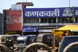
Kankavli is a city in Sindhudurg district in the Indian state of Maharashtra. It is an important city due to its central location in the Sindhudurg district. All talukas are at an equal distance from Kankavli city. There is a temple of Shri Bhalchandra Maharaj and Swyambhu Ravalnath. The Kankavli city is situated in between two west flowing rivers which carry roaring gushing waters on their rockbed to Arabian sea in monsoon. It is a culturally, educationally and socially rich and vibrant major city. A veteran Gandhian Shri Appasaheb Patwardhan founded Gopuri Ashram near Kankavli city with principles of Swadeshi, Swatchhata, Swawlamban and Sarvodaya in 1948. Kankavli is equally located from Kolhapur and Ratnagiri. This is one of the important railway stations on Konkan railway route and major towns on NH 66. Maharashtra's ex- Chief Minister Shri. Narayan Rane also hails from this area.
Gadhinglaj ([ɡəɖᵊɦiŋɡləd͡z]) is a city in India in the Kolhapur district in the southwest corner of the state of Maharashtra, India. It is located on the banks of the river Hiranyakeshi. It is the Taluka (Tehsil) headquarters of Gadhinglaj Taluka and a subdivision headquarters of the Gadhinglaj Subdivision of the Kolhapur District. It is governed by a municipal council. The rapidly growing city is the third largest in the Kolhapur District, with population of more than 50,000. Places to visit like Samagad fort, temples and beautiful weather. Info. By Vinay Gawali.
Devgad is a taluka in Sindhudurg district of Maharashtra India consisting of 98 villages. It is located on the Arabian Sea in the coastal Konkan region of Maharashtra, south of Mumbai. Devgad is known globally for its exports of locally grown Alphonso mangoes.
Chandgad is a Small city and tehsil headquarters of chandgad taluka, of Kolhapur district that is in the Indian state of Maharashtra.
Paargad Fort is situated to the south of Kolhapur in Maharashtra state in India, at a distance of around 28;km from Chandgad. One of the major attractions of this fort is its serene environment and lush green surroundings. Apart from this, it is also known for housing a wonderful bronze statue of Chatrapati Shivaji and a temple of Bhagawati Bhawani.
Asoli is a small village in Taluka Vengurla and district Sindhudurg of Maharashtra, India.
Hulsoor is a city and Taluka in the Bidar district in the Indian Southern state of Karnataka. In 2017 the village was declared a taluka.
Ajgaon is a village in the state of Maharashtra, India. It is located in the Sawantwadi taluk of Sindhudurg district in Maharashtra.
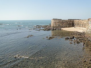
Aronda is a village in the Sindhudurg district, Maharashtra state, India. Aronda is famous for coconut cashew nuts, mangoes, jack fruit, Kokum, and rice. Aronda is a port on the boundary of Goa and Maharashtra. Aronda is next to Terekhol River, and has many ancient temples such as the Shri Sateri Bhadrakali Shri Ravalnath and Kulkar temple.
Parner taluka is a taluka in Ahmednagar district in the state of Maharashtra, India.
Shiroda is a small village in South Konkan in Vengurla taluka, Sindhudurg district, (Maharashtra), India, with a long stretch of beach. The village is famous for its pristine beaches, weekly market, clothing shops, salt pans, fish market, and jetties. Small hillocks surround the region, along with mango and cashew plantations.
Kadgaon is a town situated Gadhinglaj Taluka of Kolhapur district situated in the southwest corner of the state of Maharashtra, India. Kadgaon is about 4 km from Gadhinglaj, 79 km from Kolhapur. Kadgaon is situated on MH SH 134 and is about 15 km from National Highway 48 (NH48). It is managed by Town Council. It is in the phase of transforming from a small town to a bustling city. It is the second-largest city after Gadhinglaj in Gadhinglaj Taluka also second largest city in Gadhinglaj sub division which Include talukas of Gadhinglaj, Ajra, Bhudargad, Chandgad. As of 2012 it has a population of about 20,851. Kadgaon has amenities that are of the level of Municipal Council in India. Kadgaon has developed as an industrial hub in recent years. It has a strong agricultural sector and is known for its sugarcane, jaggery and red chili production. It is well connected to all of Kolhapur and Maharashtra. It has a very excellent civic amenities. Like in most of the case in the Maharashtra the primary Language spoken is Marathi with 20,851 speaking as their primary Language.
Mungurwadi is a town in Gadhinglaj Taluka of Kolhapur district in Maharashtra, India. In 2001 it had a population of 3,271, but as of 2011, it has a population of 12,199. It is a major market place and the tenth largest settlement in Gadhinglaj taluka. Mungurwadi is about 24 km from Gadhinglaj, 29 km from second-largest settlement Kadgaon and 12 km from National Highway 48 (NH48).
This page is based on this Wikipedia article Text is available under the CC BY-SA 4.0 license; additional terms may apply. Images, videos and audio are available under their respective licenses.