Dodge, Washington

Last updated
Dodge, Washington
USA Washington location map.svg
Red pog.svg
Dodge
Usa edcp location map.svg
Red pog.svg
Dodge
Coordinates: 46°31′29″N117°49′18″W / 46.52472°N 117.82167°W / 46.52472; -117.82167 Coordinates: 46°31′29″N117°49′18″W / 46.52472°N 117.82167°W / 46.52472; -117.82167
Country United States
State Washington
County Garfield
Elevation
[1]
1,273 ft (388 m)
Time zone UTC-8 (Pacific (PST))
  Summer (DST) UTC-7 (PDT)
ZIP code
99347
Area code(s) 509
GNIS feature ID 1530858

Dodge is an unincorporated community in Garfield County, in the Palouse region of southeastern Washington. It is located at the junction of U.S. Route 12 and State Route 127, northwest of Pomeroy. [2]

Related Research Articles

Churchill County, Nevada County in Nevada

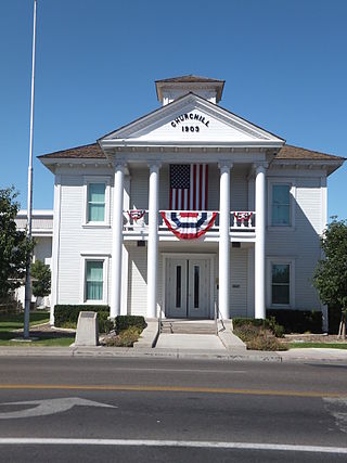
Churchill County is a county in the western U.S. state of Nevada. As of the 2010 census, the population was 24,877. Its county seat is Fallon. Named for Mexican–American War hero brevet Brigadier General Sylvester Churchill, the county was formed in 1861. It is not named after Sir Winston Churchill, born thirteen years after the county was formed and named.

Denton, Maryland Town in Maryland

Denton is a town in Caroline County, Maryland. The population of Denton was 4,418 as of the 2010 United States Census, and it is the county seat of Caroline County.

Washington Township, Armstrong County, Pennsylvania Township in Pennsylvania, United States

Washington Township is a township in Armstrong County, Pennsylvania, United States. The population was 923 at the 2010 census.

U.S. Route 197 (US 197) is a north–south United States Highway, of which all but 2.76 miles of its 69.93 miles are within the state of Oregon. The highway starts in rural Wasco County in Central Oregon at an intersection with US 97. US 197 travels north as a continuation of The Dalles-California Highway No. 4 through the cities of Maupin, Tygh Valley, and Dufur to The Dalles. Within The Dalles, the highway becomes concurrent with US 30 and intersects Interstate 84 (I-84) before it crosses over the Columbia River on The Dalles Bridge into Washington. The highway continues through the neighboring city of Dallesport in Klickitat County and terminates at a junction with State Route 14 (SR 14).

U.S. Route 195 (US 195) is a north–south United States Highway, of which all but 0.65 miles of its 94.42 miles are within the state of Washington. The highway starts in rural Idaho north of the city of Lewiston as a state highway in an interchange with US 95. As the road crosses into Washington it becomes a state highway that connects communities in the Palouse region of Eastern Washington. US 195 travels north, serving the cities of Pullman, Colfax and Rosalia in Whitman County before continuing into Spokane County to its terminus in the city of Spokane at an interchange with Interstate 90 (I-90).

Wenatchee Mountains Mountain in Washington, USA

The Wenatchee Mountains are a range of mountains in central Washington State, United States of America. A major subrange of the Cascade Range, extending east 50 miles (80 km) from the Cascade crest, the Wenatchee Mountains separate the drainage basins of the Yakima River from the Wenatchee River. The crest of the range forms part of the boundary between Chelan and Kittitas Counties.

Washington State Route 302 highway in Washington

State Route 302 (SR 302) is a 16.87-mile-long (27.15 km) state highway in the U.S. state of Washington, connecting the communities of Allyn-Grapeview and Purdy on the Kitsap Peninsula, located in Mason and Pierce counties. The highway travels southeast from SR 3 in Allyn-Grapeview along North Bay and turns east along Henderson Bay to Purdy. SR 302 intersects its spur route and turns south, ending at an interchange with SR 16 at the north end of Gig Harbor. The highway was created during the 1964 highway renumbering to replace Secondary State Highway 14A (SSH 14A) between Allyn and Purdy.

State Route 542 (SR 542) is a 57.24-mile-long (92.12 km) state highway in the U.S. state of Washington, serving Mount Baker in Whatcom County. SR 542 travels east as the Mount Baker Highway from an interchange with Interstate 5 (I-5) in Bellingham through the Nooksack River valley to the Mt. Baker Ski Area at Austin Pass. It serves as the main highway to Mount Baker and the communities of Deming, Kendall, and Maple Falls along the Nooksack River. The highway was constructed in 1893 by Whatcom County as a wagon road between Bellingham and Maple Falls and was added to the state highway system as a branch of State Road 1 in 1925. The branch was transferred to Primary State Highway 1 (PSH 1) during its creation in 1937 and became SR 542 during the 1964 highway renumbering.

Washington State Route 119 highway in Washington

State Route 119 (SR 119) is a 10.93-mile-long (17.59 km) state highway in the U.S. state of Washington, serving Lake Cushman in Mason County within Olympic National Forest. The highway, known locally as Lake Cushman Road, travels northwest into the Olympic Mountains from U.S. Route 101 (US 101) in Hoodsport to Lake Cushman and ends at a gravel road east of the entrance to Olympic National Park on Forest Highway 24 (FFH-24). A gravel road connecting Lake Cushman to the state highway system has existed since the late 1950s and was codified into the current state highway system in 1991, prior to being completely paved by 1999.

State Route 4 (SR 4) is a 62.27-mile-long (100.21 km) state highway, serving the southwestern region of the U.S. state of Washington. The highway, officially known as the Ocean Beach Highway, travels east along the Columbia River from U.S. Route 101 (US 101) at Johnston's Landing through Pacific, Wahkiakum and Cowlitz counties to an interchange with Interstate 5 (I-5) in Kelso. SR 4 is designated as part of the Lewis and Clark Trail Scenic Byway, a state scenic byway, as well as part of the National Highway System. The highway, along with I-5 and SR 14, forms the former route of US 830, which ran along the Columbia River from Johnston's Landing to Maryhill from the creation of the United States Numbered Highways in 1926 until 1968. US 830 was co-signed with Primary State Highway 12 (PSH 12) from Johnston's Landing to Kelso and was created in 1937 as the successor to various unsigned state highways.

Washington State Route 17 Highway in Washington

State Route 17 (SR 17) is a 136.67-mile-long (219.95 km) state highway serving the Columbia Plateau in the central region of the U.S. state of Washington. The highway travels through mostly rural areas of Franklin. Adams, Grant, Douglas, and Okanogan counties and is designated as part of the National Highway System between Mesa and Moses Lake and as the Coulee Corridor Scenic Byway between Othello and Coulee City for passing through the Grand Coulee. SR 17 begins in Mesa at an interchange with U.S. Route 395 (US 395) and travels north and intersects SR 26 near Othello before entering Moses Lake, where the highway intersects Interstate 90 (I-90) and travels as a partial expressway. SR 17 continues north, intersecting SR 28 in Soap Lake, through the Grand Coulee to a short concurrency with US 2 west of Coulee City. The highway turns northwest and crosses the Columbia River on the Columbia River Bridge at Bridgeport before ending at US 97 in Brewster at the southwestern edge of the Colville Indian Reservation.

Washington State Route 27 highway in Washington

State Route 27 (SR 27) is a 90-mile-long (145 km) state highway serving Whitman and Spokane counties, located in the eastern region of the U.S. state of Washington. The highway travels generally north from U.S. Route 195 (US 195) through Pullman, Palouse, Tekoa, and Spokane Valley to SR 290 north of an interchange with Interstate 90 (I-90). SR 27 serves the Palouse region as part of the Palouse Scenic Byway and travels between US 195 to the west and US 95 to the east in Idaho, with several auxiliary routes connecting to the two other highways. The highway has been part of the state highway system since 1913, as a part of the Second Division of the Eastern Route of the Inland Empire Highway between Pullman and Oakesdale that later became a branch of Primary State Highway 3 (PSH 3), as well as Secondary State Highway 3H (SSH 3H) in 1937. Both highways were combined to form SR 27 during the 1964 highway renumbering and the designation was extended south to the US 195 bypass of Pullman in 1975 and north to SR 290 in 1991.

Washington State Route 503 highway in Washington

State Route 503 (SR 503) is a 54.11-mile-long (87.08 km) state highway serving Clark and Cowlitz counties in the U.S. state of Washington. The highway travels north from a short concurrency with SR 500 in Orchards through Battle Ground, the eastern terminus of SR 502, and communities in rural Clark County before crossing the Lewis River on the Yale Bridge. SR 503 intersects its spur route and turns west to parallel the Lewis River downstream to Woodland, where the highway ends at an interchange with Interstate 5 (I-5). The highway was part of the Lewis River Road, signed as State Road 15, from 1909 until 1919. The current route of SR 503 was split between Secondary State Highway 1S (SSH 1) from Woodland to Battle Ground and SSH 1U from Battle Ground to Orchards in 1937, combined to form SR 503 during the 1964 highway renumbering. A spur route, established in 1991, travels northeast into the Gifford Pinchot National Forest along Yale Lake, serving the community of Cougar.

Washington State Route 516 highway in Washington

State Route 516 (SR 516) is a 16.49-mile-long (26.54 km) state highway in the U.S. state of Washington, serving communities in southern King County. The highway travels east as the Kent-Des Moines Road and the Kent-Kangley Road from a concurrency with SR 509 in Des Moines through Kent and Covington to an intersection with SR 169 in Maple Valley. SR 516, designated as part of the National Highway System within Kent, intersects three major freeways in the area: Interstate 5 (I-5) in western Kent, SR 167 in downtown Kent, and SR 18 in Covington. The roadway, built in the 1890s, was codified in 1937 as Secondary State Highway 1K (SSH 1K) from Des Moines to Kent and SSH 5A from Kent to Maple Valley. The two highways were combined during the 1964 highway renumbering to form SR 516 on its current route.

Washington State Route 127 highway in Washington

State Route 127 (SR 127) is a 27.05-mile-long (43.53 km) state highway serving the eastern region of the U.S. state of Washington. The highway, listed on the National Highway System, begins in rural Garfield County at U.S. Route 12 (US 12) and travels north across the Snake River on the Elmer Huntley Bridge. The roadway continues into Whitman County before it ends at SR 26 in Dusty. SR 127 formed a section of the Inland Empire Highway and Primary State Highway 3 (PSH 3) prior to becoming US 295 in 1926. US 295 was decommissioned in 1968 and replaced by a longer SR 127, traveling its full length from Dodge to Colfax from its establishment in 1970 until an extension of SR 26 to Colfax in 1979.

Washington State Route 116 highway in Washington

State Route 116 (SR 116) is a 9.83-mile-long (15.82 km) state highway in the U.S. state of Washington, serving Indian and Marrowstone islands in Jefferson County. The two-lane highway travels east from SR 19 in Port Hadlock-Irondale across the Portage Canal to Indian Island and Marrowstone Island, turning north and ending at the entrance to Fort Flagler State Park. SR 116 was created in 1991 and follows the route of Flagler Road, built and paved in the 1960s.

Washington State Route 173 highway in Washington

State Route 173 (SR 173) is an 11.86-mile-long (19.09 km) state highway serving Douglas and Okanogan counties in the U.S. state of Washington. The highway travels northwest along the Columbia River from SR 17 in Bridgeport to U.S. Route 97 (US 97) in Brewster. It serves as an alternate route to SR 17, which travels north of the Columbia River, and serves the Chief Joseph State Park and the Bridgeport Bar State Wildlife Recreation Area. SR 173 was established during the 1964 highway renumbering and codified in 1970, but it has been a part of the state highway system since 1931 as a branch of State Road 10, later Primary State Highway 10 (PSH 10). The highway crosses the Columbia River on the Brewster Bridge, which originally opened in 1928 and was destroyed in 1967 before being re-built a decade later.

Washington State Route 215 highway in Washington

State Route 215 (SR 215) is a 6.24-mile long (10.04 km) state highway serving Okanogan County in the U.S. state of Washington. The highway travels northeast parallel to the Okanogan River from SR 20 in Okanogan to SR 155 Spur in Downtown Omak. SR 215 turns east to end at an intersection with SR 20 and U.S. Route 97 (US 97) in North Omak. The highway was previously part of State Road 10 and Primary State Highway 10 (PSH 10), concurrent with US 97, until a bypass of Omak was built in the 1960s. SR 20 was routed onto the highway after the 1964 highway renumbering, but was moved to the bypass and replaced by SR 215 in 1973.

Washington State Route 272 highway in Washington

State Route 272 (SR 272) is a 19.22-mile (30.93 km) long state highway serving Whitman County in the U.S. state of Washington. The highway travels from U.S. Route 195 (US 195) in Colfax to a short concurrency with parent route SR 27 in Palouse before ending at the Idaho state line and becoming Idaho State Highway 6 (SH-6). Prior to 1964, the highway was split between Secondary State Highway 3F (SSH 3F) from Colfax to Palouse and a branch of Primary State Highway 3 (PSH 3) from Palouse to the Idaho state line.

Washington Township, Fremont County, Iowa Township in Iowa, United States

Washington Township is one of thirteen townships in Fremont County, Iowa, United States. As of the 2010 census, its population was 350 and it contained 155 housing units.

References

  1. "US Board on Geographic Names". United States Geological Survey. October 25, 2007. Retrieved August 23, 2018.
  2. "Dodge, Washington". Geographic Names Information System . United States Geological Survey . Retrieved August 23, 2018.