
Bryce Canyon National Park is an American national park located in southwestern Utah. The major feature of the park is Bryce Canyon, which despite its name, is not a canyon, but a collection of giant natural amphitheaters along the eastern side of the Paunsaugunt Plateau. Bryce is distinctive due to geological structures called hoodoos, formed by frost weathering and stream erosion of the river and lake bed sedimentary rocks. The red, orange, and white colors of the rocks provide spectacular views for park visitors. Bryce Canyon National Park is much smaller, and sits at a much higher elevation than nearby Zion National Park. The rim at Bryce varies from 8,000 to 9,000 feet.
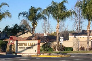
Canyon Lake is a city and gated community on Canyon Lake reservoir, located in the Inland Empire, Riverside County, California, United States.

The Texas Panhandle is a region of the U.S. state of Texas consisting of the northernmost 26 counties in the state. The panhandle is a rectangular area bordered by New Mexico to the west and Oklahoma to the north and east. The Handbook of Texas defines the southern border of Swisher County as the southern boundary of the Texas Panhandle region.

The Wasatch Range is a mountain range that stretches approximately 160 miles (260 km) from the Utah-Idaho border, south through central Utah in the western United States. It is the western edge of the greater Rocky Mountains, and the eastern edge of the Great Basin region. The northern extension of the Wasatch Range, the Bear River Mountains, extends just into Idaho, constituting all of the Wasatch Range in that state.

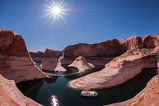
Lake Powell is a reservoir on the Colorado River, straddling the border between Utah and Arizona, United States. Most of Lake Powell, along with Rainbow Bridge National Monument, is located in Utah. It is a major vacation spot that around two million people visit every year. It is the second largest man-made reservoir by maximum water capacity in the United States behind Lake Mead, storing 24,322,000 acre feet (3.0001×10¹⁰ m3) of water when full. However, due to high water withdrawals for human and agricultural consumption, and because of subsequent droughts in the area, Lake Mead has fallen below Lake Powell in size several times during the 21st century in terms of volume of water, depth and surface area.
Glen Canyon National Recreation Area is a recreation and conservation unit of the National Park Service (USA) that encompasses the area around Lake Powell and lower Cataract Canyon in Utah and Arizona, covering 1,254,429 acres (5,076 km2) of mostly desert. The recreation area borders Capitol Reef National Park and Canyonlands National Park on the north, Grand Staircase-Escalante National Monument on the west, Vermilion Cliffs National Monument and the northeasternmost reaches of Grand Canyon National Park on the southwest, and the Navajo Nation on the southeast.

Coquihalla Canyon Provincial Park, popularly called the Othello Tunnels is a provincial park located near Hope, British Columbia focused on the canyon of the Coquihalla River and a decommissioned railway grade, now a walking trail, leading eventually to Coquihalla Pass. Originally part of the Kettle Valley Railway, five tunnels and a series of bridges follow a relatively straight line through the gorge, which is lined with sheer, flat rock cliffs.

The Shulaps Range is a subrange of the Chilcotin Ranges subset of the Pacific Ranges of the Coast Mountains in southwest-central British Columbia. The range is 55 km NW–SE and 15 km SW–NE and 2,970 km² (1150 mi²) in area.

Kanopolis State Park contains a reservoir, desert plants such as yucca, a prairie dog town, and scenic sandstone canyons. It is located in the Smoky Hills region of the U.S. state of Kansas. The park is located southwest of the city of Salina, just south of I-70.

The Secwépemc, known in English as the Shuswap people, are a First Nations people residing in the Canadian province of British Columbia. Secwepemcúĺecw, their country, ranges from the eastern Chilcotin Plateau and the Cariboo Plateau southeast through the Thompson Country to Kamloops and the Shuswap Country, and spans the Selkirk Mountains and Big Bend of the Columbia River to include the northern part of the Columbia Valley region. The country's traditional territory covers approximately 145,000 square kilometres. They relied heavily on hunting, trading and fishing to support their communities. The Secwepemc are perhaps the most numerous of the Interior Salish peoples of British Columbia if based upon the numbers who speak their language.

The Okanagan Trail was an inland route to the Fraser Canyon Gold Rush from the Lower Columbia region of the Washington and Oregon Territories in 1858-1859. The route was essentially the same as that used by the Hudson's Bay Company fur brigades, following the Columbia River to the confluence of the Okanogan River, and then up that river's watercourse via Osoyoos, Skaha (Dog) and Okanagan Lakes, then using a pass via Monte Creek to Fort Kamloops, at the confluence of the North and South Thompson Rivers. The route then went west from there down the Thompson River either to the lower gold-bearing bars of the Fraser River between what is now Lytton, British Columbia and Yale, British Columbia, or via Hat Creek and Marble Canyon to the upper Fraser goldfields around present-day Lillooet, British Columbia. A shorter branch-route to the lower Thompson and lower Fraser Canyon diverged from the main route at the confluence of the Similkameen River and the Okanogan. Cayoosh and The Fountains are today's Lillooet, British Columbia and environs.

Prairie Dog Town Fork Red River is a sandy-braided stream about 120 mi (193 km) long, formed at the confluence of Palo Duro Creek and Tierra Blanca Creek, about 1.8 mi (2.9 km) northeast of Canyon in Randall County, Texas, and flowing east-southeastward to the Red River about 1 mi (2 km) east of the 100th meridian, 8 mi (13 km) south-southwest of Hollis, Oklahoma.

Oliver Lee Memorial State Park is a state park of New Mexico, United States, whose two tracts preserve a canyon in the Sacramento Mountains and Oliver Lee's historic 19th-century ranch house. The 640-acre (260 ha) park is located in Otero County at an elevation of 4,363 feet (1,330 m). It is situated at the base of Dog Canyon and provides opportunities for camping, hiking, picnicking, wildlife viewing, a nature trail, and guided tours of the ranch house.

The Canoe Creek Band/Dog Creek Indian Band, also known as the Canoe Creek First Nation and/or Dog Creek First Nation is a First Nations government of the Secwepemc (Shuswap) Nation, located in the Fraser Canyon-Cariboo region of the Central Interior of the Canadian province of British Columbia. It was created when the government of the then-Colony of British Columbia established an Indian Reserve system in the 1860s. It is a member government of the Northern Shuswap Tribal Council.
Millcreek Canyon is a canyon in the Wasatch Mountains and part of Millcreek City on the east side of the Salt Lake Valley, Utah. It is a popular recreation area both in the summer and in the winter. It was named after all the mills that were once located in the densely forested canyon. It is home to two restaurants and six Boy Scout Day Camps.

The East Desert Range is a mountain range in Lincoln County, Nevada.

Big Cottonwood Creek is one of the largest streams entering Salt Lake Valley from the east from the Wasatch Mountains. The creek flows through the Big Cottonwood Canyon in a westerly direction until it emerges into Salt Lake Valley about eighteen miles (29 km) from its highest source. Thence its course is northwesterly through Cottonwood Heights, Holladay, and Murray, Utah until it empties into the Jordan River about five miles (8.0 km) south of Salt Lake City. In the summer its waters are all used for irrigation purposes. From its source to its original outlet into the Jordan River is a distance of about twenty six miles.

