
Phungling Municipality is a municipality located in Taplejung District in the Province No. 1 of Nepal. The municipality was formed merging the then two Village Development Committees of Phungling and Dokhu in May 2014. At the time of the 2011 Nepal census it had a population of 19,085 people and 4,480 individual households.

Myanglung is a municipality and the district headquarters of Terhathum District of Province No. 1 in eastern Nepal. The municipality is situated at an elevation of about 1500 metres above sea level. Myanglung was converted into a municipality from a village development committee on 18 May 2014, merging the existing village development committees of Myanglung, Piple, Jirikhimti, Ambung, Sabla and Tamphula. According to the census of 2011 the total population of Myanglung is 19,659 including five VDCs.

Nijgadh is a town and municipality in Bara District in the Narayani Zone, Province no. 2 of south-eastern Nepal. The existing Nijgadh VDC was merged with the existing Ratnapuri VDC and Bharatganj Singaul VDC in May 2014.
Dullu is an urban Municipality in Dailekh District of Karnali Pradesh in Nepal.
Jyamrukot is a market center in Beni Municipality in Myagdi District in the Dhaulagiri Zone of western-central Nepal. The former village development committee was annexed to form the new municipality on May 18, 2014. At the time of the 1991 Nepal census it had a population of 2825 people living in 578 individual households.
Dandagaun, Rapti is market center in Sharada Municipality in Salyan District in the Rapti Zone of western-central Nepal. The place formerly existing as Village Development Committee was annexed to form a new municipality since 18 May 2014. At the time of the 1991 Nepal census it had a population of 4198 people living in 740 individual households.
Hiwalcha is market center in Sharada Municipality in Salyan District in the Rapti Zone of western-central Nepal. The place formerly existing as Village Development Committee was annexed to form a new municipality since 18 May 2014. At the time of the 1991 Nepal census it had a population of 3533 people living in 658 individual households.
Kajeri is market center in Sharada Municipality in Salyan District in the Rapti Zone of western-central Nepal. The place formerly existing as Village Development Committee was annexed to form a new municipality since 18 May 2014. At the time of the 1991 Nepal census it had a population of 3998 people living in 669 individual households.
Khalanga is market center in Sharada Municipality in Salyan District of Karnali Province of Nepal. The place formerly existing as Village Development Committee was annexed to form a new municipality since 18 May 2014. It is the district headquarter of Salyan District. At the time of the 1991 Nepal census it had a population of 6380.
Marke is market center in Sharada Municipality in Salyan District in the Rapti Zone of western-central Nepal. The place formerly existing as Village Development Committee was annexed to form a new municipality since 18 May 2014. At the time of the 1991 Nepal census it had a population of 4189 people living in 770 individual households.
Katari is a Municipality in Udayapur District in the Province No. 1 of south-eastern Nepal.It lies by the Tawa river having the bridge of length 123.5m. This was established by merging two existing village development committees i.e. Triveni and Katari on 18 May 2014. At the time of the 1991 Nepal census it had a population of 7230 people living in 1410 individual households. Thirty years later, Katari had undergone rapid growth, achieving a population of 56,146 people by the 2011 census.
Chainpur is a municipality in Sankhuwasabha District in the Kosi Zone of north-eastern Nepal. It was formed by merging five villages i.e. Chainpur, Siddhakali, Siddhapokhari, Baneshwar and Kharang. The municipality was implemented on 18 May 2014. At the time of the 1991 Nepal census it had a population of 4933 people in 948 households.
Khokling is a village development committee in the Himalayas of Taplejung District in the Province No. 1 of north-eastern Nepal. At the time of the 2011 Nepal census it had a population of 3,376 people living in 693 individual households. There were 1,614 males and 1,762 females at the time of census.
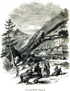
Olangchung Gola is a village in ward no. 7 of Phaktanglung rural municipality of Taplejung District of Province No. 1 in Nepal. Olangchung is surrounded by Lelep village to the east and Tibet to the north, Sankhuwasabha District to west and Mikkwakhola rural municipality to south. It is located to the north of Tamor River in the mountainous area in the northwest of Taplejung District bordering Tibet, China. Lately the river flowing next to the village is gradually expanding towards the village posing a serious threat of submerging the village.
Ghailadubba is a small town and ancient market place in Kankai Municipality in Jhapa District in the Province No. 1 of south-eastern Nepal. At the time of the 1991 Nepal census it had a population of 11,185.
Chokmagu is a market center of Phidim Municipality in Panchthar District in the Province No. 1 in eastern Nepal. It was annexed to Phidim on 18 May 2014 to form the municipality. At the time of the 1991 Nepal census it had a population of 5698 people living in 835 individual households.

Phidim Municipality is the headquarters of the Panchthar District in the Province No. 1 of eastern Nepal. Phidim was upgraded to a 'municipality' from a 'village', when a development committee merged with other VDCs - including the Phidim, Chokmagu and Siwa villages - on May 18, 2014. It offers a route for trekkers and locals, who travel to and from the Taplejung district bordering with the Tibetan Autonomous Region of China. It is also a commercial hub for the rural surroundings.
Kaseni कसेनी is a town center under Belbari Municipality in Morang District in the Kosi Zone of south-eastern Nepal. Kaseni was merged into Belbari Municipality in May 2014.
Pathari Shanishchare (पथरी-शनिश्चरे) is a Municipality in Morang District in the Koshi Zone of south-eastern Nepal. It was formed by merging three existing village development committees i.e. Hasandaha, Pathari and Sanischare in May 2014.
Sundar Haraicha is a municipality in Morang District of Province No. 1 in Nepal that was established on 10 March 2017 by merging the former municipalities Sundar Dulari and Koshi Haraicha. At the time of the 2011 Nepal census, the localities formed had a joint population of 80,518 people living in 18,610 individual households.
