| Dolenje Kronovo | |
|---|---|
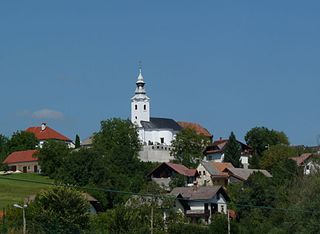
Postcard of Dolenje Kronovo | |
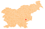
 Dolenje Kronovo Location in Slovenia | |
| Coordinates: 45°51′16.12″N15°15′24.79″E / 45.8544778°N 15.2568861°E Coordinates: 45°51′16.12″N15°15′24.79″E / 45.8544778°N 15.2568861°E | |
| Country | |
| Traditional region | Lower Carniola |
| Statistical region | Southeast Slovenia |
| Municipality | Šmarješke Toplice |
| Area | |
| • Total | 1.87 km2 (0.72 sq mi) |
| Elevation | 158.1 m (518.7 ft) |
| Population (2002) | |
| • Total | 135 |
| [1] | |

Dolenje Kronovo (pronounced [dɔˈleːnjɛ ˈkɾoːnɔʋɔ] ) is a village in the Municipality of Šmarješke Toplice in southeastern Slovenia. The area is part of the historical region of Lower Carniola. The municipality is now included in the Southeast Slovenia Statistical Region. [2]

The Municipality of Šmarješke Toplice is a municipality in the traditional region of Lower Carniola in southeastern Slovenia. The seat of the municipality is the town of Šmarješke Toplice. The municipality is now included in the Southeast Slovenia Statistical Region.

Slovenia, officially the Republic of Slovenia, is a sovereign state located in southern Central Europe at a crossroads of important European cultural and trade routes. It is bordered by Italy to the west, Austria to the north, Hungary to the northeast, Croatia to the southeast, and the Adriatic Sea to the southwest. It covers 20,273 square kilometers (7,827 sq mi) and has a population of 2.07 million. One of the successor states of the former Yugoslavia, Slovenia is a parliamentary republic and a member of the United Nations, of the European Union, and of NATO. The capital and largest city is Ljubljana.

Lower Carniola is a traditional region in Slovenia, the southeastern part of the historical Carniola region.
The local church is dedicated to Saint Nicholas and belongs to the Parish of Bela Cerkev. It is a medieval church that was restyled in the Baroque in 1739. [3]

A church building or church house, often simply called a church, is a building used for Christian religious activities, particularly for Christian worship services. The term is often used by Christians to refer to the physical buildings where they worship, but it is sometimes used to refer to buildings of other religions. In traditional Christian architecture, the church is often arranged in the shape of a Christian cross. When viewed from plan view the longest part of a cross is represented by the aisle and the junction of the cross is located at the altar area.

Saint Nicholas of Myra, also known as Nicholas of Bari, was an early Christian bishop of the ancient Greek maritime city of Myra in Asia Minor during the time of the Roman Empire. He is revered by many Christians as a saint. Because of the many miracles attributed to his intercession, he is also known as Nicholas the Wonderworker. Saint Nicholas is the patron saint of sailors, merchants, archers, repentant thieves, children, brewers, pawnbrokers, and students in various cities and countries around Europe. His reputation evolved among the faithful, as was common for early Christian saints, and his legendary habit of secret gift-giving gave rise to the traditional model of Santa Claus through Sinterklaas.
A parish is a territorial entity in many Christian denominations, constituting a division within a diocese. A parish is under the pastoral care and clerical jurisdiction of a parish priest, who might be assisted by one or more curates, and who operates from a parish church. Historically, a parish often covered the same geographical area as a manor. Its association with the parish church remains paramount.