Gmina Łączna is a rural gmina in Skarżysko County, Świętokrzyskie Voivodeship, in south-central Poland. Its seat is the village of Łączna, which lies approximately 17 kilometres (11 mi) south-west of Skarżysko-Kamienna and 18 km (11 mi) north-east of the regional capital Kielce.

Kamieniec is a village in the administrative district of Gmina Bodzentyn, within Kielce County, Świętokrzyskie Voivodeship, in south-central Poland. It lies approximately 5 kilometres (3 mi) north-west of Bodzentyn and 22 km (14 mi) north-east of the regional capital Kielce.
Ściegnia is a village in the administrative district of Gmina Bodzentyn, within Kielce County, Świętokrzyskie Voivodeship, in south-central Poland. It lies approximately 6 kilometres (4 mi) north-west of Bodzentyn and 23 km (14 mi) north-east of the regional capital Kielce.
Ameliówka is a village in the administrative district of Gmina Masłów, within Kielce County, Świętokrzyskie Voivodeship, in south-central Poland.
Barcza is a village in the administrative district of Gmina Masłów, within Kielce County, Świętokrzyskie Voivodeship in south-central Poland.
Brzezinki is a village in the administrative district of Gmina Masłów, within Kielce County, Świętokrzyskie Voivodeship, in south-central Poland. It lies approximately 4 kilometres (2 mi) north-east of Masłów and 12 km (7 mi) north-east of the regional capital Kielce.
Ciekoty is a village in the administrative district of Gmina Masłów, within Kielce County, Świętokrzyskie Voivodeship, in south-central Poland. It lies approximately 6 kilometres (4 mi) east of Masłów and 14 km (9 mi) east of the regional capital Kielce. Geographically, it lies near the base of Mount Radostowa in the Łysogóry range of the Świętokrzyskie Mountains.
Dąbrowa is a village in the administrative district of Gmina Masłów, within Kielce County, Świętokrzyskie Voivodeship, in south-central Poland. It lies approximately 3 kilometres (2 mi) west of Masłów and 6 km (4 mi) north-east of the regional capital Kielce.
Mąchocice Kapitulne is a village in the administrative district of Gmina Masłów, within Kielce County, Świętokrzyskie Voivodeship, in south-central Poland. It lies approximately 3 kilometres (2 mi) east of Masłów and 10 km (6 mi) east of the regional capital Kielce.
Mąchocice-Scholasteria is a village in the administrative district of Gmina Masłów, within Kielce County, Świętokrzyskie Voivodeship, in south-central Poland. It lies approximately 4 kilometres (2 mi) east of Masłów and 13 km (8 mi) east of the regional capital Kielce.
Masłów Drugi is a village in the administrative district of Gmina Masłów, within Kielce County, Świętokrzyskie Voivodeship, in south-central Poland. It lies approximately 2 kilometres (1 mi) north-east of Masłów and 9 km (6 mi) north-east of the regional capital Kielce.
Wiśniówka is a village in the administrative district of Gmina Masłów, within Kielce County, Świętokrzyskie Voivodeship, in south-central Poland. It lies approximately 5 kilometres (3 mi) north-west of Masłów and 7 km (4 mi) north-east of the regional capital Kielce.
Wola Kopcowa is a village in the administrative district of Gmina Masłów, within Kielce County, Świętokrzyskie Voivodeship, in south-central Poland. It lies approximately 4 kilometres (2 mi) south of Masłów and 7 km (4 mi) east of the regional capital Kielce.

Samsonów is a village in the administrative district of Gmina Zagnańsk, within Kielce County, Świętokrzyskie Voivodeship, in south-central Poland. It lies approximately 4 kilometres (2 mi) north-west of Zagnańsk and 12 km (7 mi) north of the regional capital Kielce.
Boleszyn is a village in the administrative district of Gmina Waśniów, within Ostrowiec County, Świętokrzyskie Voivodeship, in south-central Poland. It lies approximately 5 kilometres (3 mi) north-west of Waśniów, 16 km (10 mi) west of Ostrowiec Świętokrzyski, and 40 km (25 mi) east of the regional capital Kielce.
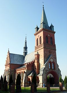
Masłów is a village in Kielce County, Świętokrzyskie Voivodeship, in south-central Poland. It is the seat of the gmina called Gmina Masłów. It lies approximately 9 km (6 mi) east of the regional capital Kielce. In the local church there is a monumental Altar of Transfiguration of Jesus and also Stations of the Cross designed by Józef Gosławski.
Jasieniec is a village in the administrative district of Gmina Pilica, within Zawiercie County, Silesian Voivodeship, in southern Poland. It lies approximately 11 kilometres (7 mi) north-east of Pilica, 24 km (15 mi) east of Zawiercie, and 62 km (39 mi) north-east of the regional capital Katowice.
Zielony Dół is a settlement in the administrative district of Gmina Krokowa, within Puck County, Pomeranian Voivodeship, in northern Poland. It lies approximately 6 kilometres (4 mi) south of Krokowa, 14 km (9 mi) west of Puck, and 50 km (31 mi) north-west of the regional capital Gdańsk.
Zofijówka is a settlement in the administrative district of Gmina Stawiguda, within Olsztyn County, Warmian-Masurian Voivodeship, in northern Poland. It lies approximately 9 kilometres (6 mi) north of Stawiguda and 9 km (6 mi) south-west of the regional capital Olsztyn.


