Gmina Łączna is a rural gmina in Skarżysko County, Świętokrzyskie Voivodeship, in south-central Poland. Its seat is the village of Łączna, which lies approximately 17 kilometres (11 mi) south-west of Skarżysko-Kamienna and 18 km (11 mi) north-east of the regional capital Kielce.

Partyzancka Kolonia is a village in the administrative district of Gmina Wojsławice, within Chełm County, Lublin Voivodeship, in eastern Poland. It lies approximately 3 kilometres (2 mi) east of Wojsławice, 28 km (17 mi) south of Chełm, and 80 km (50 mi) south-east of the regional capital Lublin.
Stara Wieś is a village in the administrative district of Gmina Biała Rawska, within Rawa County, Łódź Voivodeship, in central Poland. It lies approximately 3 kilometres (2 mi) south-east of Biała Rawska, 19 km (12 mi) east of Rawa Mazowiecka, and 72 km (45 mi) east of the regional capital Łódź.
Ameliówka is a village in the administrative district of Gmina Masłów, within Kielce County, Świętokrzyskie Voivodeship, in south-central Poland.
Barcza is a village in the administrative district of Gmina Masłów, within Kielce County, Świętokrzyskie Voivodeship in south-central Poland.
Brzezinki is a village in the administrative district of Gmina Masłów, within Kielce County, Świętokrzyskie Voivodeship, in south-central Poland. It lies approximately 4 kilometres (2 mi) north-east of Masłów and 12 km (7 mi) north-east of the regional capital Kielce.
Ciekoty is a village in the administrative district of Gmina Masłów, within Kielce County, Świętokrzyskie Voivodeship, in south-central Poland. It lies approximately 6 kilometres (4 mi) east of Masłów and 14 km (9 mi) east of the regional capital Kielce. Geographically, it lies near the base of Mount Radostowa in the Łysogóry range of the Świętokrzyskie Mountains.
Dąbrowa is a village in the administrative district of Gmina Masłów, within Kielce County, Świętokrzyskie Voivodeship, in south-central Poland. It lies approximately 3 kilometres (2 mi) west of Masłów and 6 km (4 mi) north-east of the regional capital Kielce.
Dolina Marczakowa is a village in the administrative district of Gmina Masłów, within Kielce County, Świętokrzyskie Voivodeship, in south-central Poland. It lies approximately 3 kilometres (2 mi) north of Masłów and 10 km (6 mi) north-east of the regional capital Kielce.

Domaszowice is a village in the administrative district of Gmina Masłów, within Kielce County, Świętokrzyskie Voivodeship, in south-central Poland. It lies approximately 6 kilometres (4 mi) south-west of Masłów and 6 km (4 mi) south-east of the regional capital Kielce.
Mąchocice Kapitulne is a village in the administrative district of Gmina Masłów, within Kielce County, Świętokrzyskie Voivodeship, in south-central Poland. It lies approximately 3 kilometres (2 mi) east of Masłów and 10 km (6 mi) east of the regional capital Kielce.
Masłów Drugi is a village in the administrative district of Gmina Masłów, within Kielce County, Świętokrzyskie Voivodeship, in south-central Poland. It lies approximately 2 kilometres (1 mi) north-east of Masłów and 9 km (6 mi) north-east of the regional capital Kielce.
Wiśniówka is a village in the administrative district of Gmina Masłów, within Kielce County, Świętokrzyskie Voivodeship, in south-central Poland. It lies approximately 5 kilometres (3 mi) north-west of Masłów and 7 km (4 mi) north-east of the regional capital Kielce.
Wola Kopcowa is a village in the administrative district of Gmina Masłów, within Kielce County, Świętokrzyskie Voivodeship, in south-central Poland. It lies approximately 4 kilometres (2 mi) south of Masłów and 7 km (4 mi) east of the regional capital Kielce.
Bilcza is a village in the administrative district of Gmina Morawica, within Kielce County, Świętokrzyskie Voivodeship, in south-central Poland. It lies approximately 5 kilometres (3 mi) north of Morawica and 12 km (7 mi) south of the regional capital Kielce.
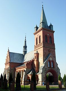
Masłów is a village in Kielce County, Świętokrzyskie Voivodeship, in south-central Poland. It is the seat of the gmina called Gmina Masłów. It lies approximately 9 km (6 mi) east of the regional capital Kielce. In the local church there is a monumental Altar of Transfiguration of Jesus and also Stations of the Cross designed by Józef Gosławski.
Morawy-Wicherki is a village in the administrative district of Gmina Gołymin-Ośrodek, within Ciechanów County, Masovian Voivodeship, in east-central Poland.
Marianów is a village in the administrative district of Gmina Solec nad Wisłą, within Lipsko County, Masovian Voivodeship, in east-central Poland. It lies approximately 7 kilometres (4 mi) south of Solec nad Wisłą, 13 km (8 mi) south-east of Lipsko, and 138 km (86 mi) south-east of Warsaw.
Borowo is a village in the administrative district of Gmina Kalisz Pomorski, within Drawsko County, West Pomeranian Voivodeship, in north-western Poland. It lies approximately 11 kilometres (7 mi) north-west of Kalisz Pomorski, 21 km (13 mi) south of Drawsko Pomorskie, and 80 km (50 mi) east of the regional capital Szczecin.


