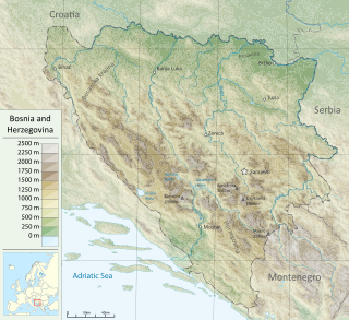
Bosnia and Herzegovina is located in Southeastern Europe. Situated in the western Balkans, it has a 932 km (579 mi) border with Croatia to the north and southwest, a 357 km (222 mi) border with Serbia to the east, and a 249 km (155 mi) border with Montenegro to the southeast. It borders the Adriatic Sea along its 20 km (12 mi) coastline.

The Herzegovina-Neretva Canton is one of 10 cantons of the Federation of Bosnia and Herzegovina in Bosnia and Herzegovina.

The Bosna is the third longest river in Bosnia and Herzegovina, and is considered one of the country's three major internal rivers, along with the Neretva and the Vrbas. The other three major rivers of Bosnia and Herzegovina are the Una, to the northwest; the Sava, to the north, and the Drina, to the east. This river is the namesake of Bosnia. The river Bosna flows for 282 kilometers (175 mi).

The Neretva, also known as Narenta, is one of the largest rivers of the eastern part of the Adriatic basin. Four hydroelectric power plants with large dams provide flood protection, electicity and water storage. The Neretva is recognized for its natural environment and diverse landscapes.

The Una is a border river between Bosnia and Herzegovina and Croatia and a right tributary of the Sava river. It is part of the Black Sea drainage basin, and its watershed has a size of 10,200 km2 (3,900 sq mi), of which 8,080 km2 (3,120 sq mi) belongs to Bosnia and Herzegovina, and 2,120 km2 (820 sq mi) to Croatia. The total length of the river is 212 km (132 mi). The source of the river is located near the village of Donja Suvaja in Croatia, and its mouth is located near the village of Jasenovac, on the border with Bosnia. The largest right tributaries are the Krka, Unac, Krušnica and Sana rivers, and the largest left tributary is the Klokot river. Its longest headwater is the Unac river. The largest and most important city located on the river is Bihać. Other, important cities and towns are Bosanska Krupa, Bosanski Novi and Bosanska Kostajnica. The river is characterized by a multitude of waterfalls, rapids, karst springs and relatively untouched nature. A large part of the upper river is part of the Una National Park.
The Trebišnjica is a river in Bosnia and Herzegovina, and the right tributary of the Neretva. Before it was utilized for hydro exploitation via various hydrotechnical interventions and systems with different purposes, Trebišnjica used to be a sinking river, rising and sinking through its course before resurfacing at various places from the Neretva river below the Čapljina to the Adriatic coast, and along the coast from the Neretva Delta to Sutorina.

Blidinje plateau is a karst plateau in Bosnia and Herzegovina, situated at the heart of Dinaric Alps, between major mountains of the range, Čvrsnica, Čabulja and Vran, with characteristic karstic features such as Dugo Polje field, Blidinje Lake, Grabovica and Drežnica valleys, and others. It represents important natural, hydrogeological reservation in karst of Bosnia and Herzegovina, with significant cultural and historical heritage, and Dinarides in general.

Salmo dentex is a variety of trout, a freshwater fish in the family Salmonidae, found in the western Balkans. Until recently the identity, biological distinctness and species status of the dentex trout were not properly clarified, but genetic data now suggest it is not a monophyletic unit that could be distinguished from other salmonids as a separate species.

The Drina is a 346 km (215 mi) long river in the Balkans, which forms a large portion of the border between Bosnia and Herzegovina and Serbia. It is the longest tributary of the Sava River and the longest karst river in the Dinaric Alps which belongs to the Danube River drainage basin. Its name is derived from the Roman name of the river which in turn is derived from Greek.

Konjic is a City and a town located in the Herzegovina-Neretva Canton of the Federation of Bosnia and Herzegovina, one of two entities that make up Bosnia and Herzegovina. It is located in northern Herzegovina, around 60 kilometres (37 mi) southwest of Sarajevo, in a mountainous, heavily wooded area, and is 268 m (879 ft) above sea level. The municipality extends on both sides of the Neretva River. According to the 2013 census, the city of Konjic has a population of 10,732 inhabitants, whereas the municipality has 25,148.

Rakitnica is the main tributary of the first section of the Neretva river, also called Upper Neretva (Bosnian: Gornja Neretva). It meets Neretva from the right, flowing from north to south, between Bjelašnica and Visočica mountains.

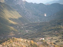
Glavatičevo is a small village in Konjic Municipality, Bosnia and Herzegovina, which is a central village to a group of villages of a wider Glavatičevo, positioned 30 km southeast of Konjic, within a wide Župa Valley straddling the Neretva river. The village and its wider areal, with surrounding villages and the valley, is also referred to as Župa Glavatičevo, or Komska Župa, or simply Župa (transl. parish).

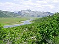
Upper Neretva, is the upper course of the Neretva river, including vast mountainous area surrounding the Neretva, with numerous human settlements, peaks and forests, numerous streams and well-springs, three major glacial lakes near the river and even more scattered across the mountains of Treskavica and Zelengora, in a wider area of the Upper Neretva with its flora and fauna.
The fish fauna of the Neretva river basin in the western Balkans is representative of the Dinaric karst region and characterized by several endemic and endangered species.

The environment of Bosnia and Herzegovina consists of diverse climates, flora and fauna, natural landmarks and landscapes. The climate ranges from continental, oceanic, subtropical and Mediterranean throughout different regions of the country. Most of the Dinaric Alps are located in Bosnia and Herzegovina, the highest elevation point is the mountain Maglic at 2,386 (7,828 ft), while the lowest point of elevation is the Adriatic Sea in the South of the country. 42.8% of the land is covered in thick forests. The country is rich in water resources, and in certain places, rivers and springs may be used without previous filtration. Significant rivers are the Drina, Neretva, Sava, Bosna and Una. Important national parks include Kozara National Park, Sutjeska National Park, and Una National Park, all nationally protected areas.
Dianthus freynii, or Freyn's carnation, in Bosnian Freynov karanfil or Freynov klinčić, is a plant that is endemic of Herzegovina karst, Bosnia and Herzegovina. It belongs to the family Caryophyllaceae (carnations).

The Zalomka is a karstic river in the southern part of Bosnia and Herzegovina, and as part of the Neretva river system it is one of the largest sinking rivers in the country and Dinarides. It rises under the Morine plateau, near Brajićevići village in Gacko municipality, but also collects its upper course waters from Gatačko Polje.

Ljuta, also called Dindolka, is one of the main tributaries of the first section of the Neretva river, also called Upper Neretva (Bosnian: Gornja Neretva). It meets Neretva from the right, flowing from north to south, between Treskavica and Visočica mountains.

The Ribnik is a river in western Bosnia and Herzegovina. It is a headwater tributary of the Sana, which it meat at Strane and Velije hamlets of the Gornji Ribnik village, 17 km below the Sana's own source springs, bringing in a large amounts of water to the still young Sana. It is among shortest of the Sana tributaries but at the same time among largest by the volume it discharges into the receiving Sana. The Ribnik is well known as a prime fly fishing fishery and is popular among anglers throughout the world.
Veliki Movran or simply Movran, is a waterfall in Bosnia and Herzegovina. The waterfall falls from the cliffs of Čvrsnica into the Drežnica Valley, through which runs a small mountain river of Drežanka, a right tributary of the Neretva. It appears intermittently, in the late winter and during spring in the season of snow melting, or during heavy and prolonged rainfall, usually in late autumn, winter and early spring.