
Lovech Province is one of the 28 provinces of Bulgaria, lying at the northern centre of the country. It is named after its main city: Lovech. As of December 2009, the population of the area was151,153.

Razgrad Province is a province in Northeastern Bulgaria, geographically part of the Ludogorie region. It is named after its administrative and industrial centre: the town of Razgrad. As of December 2009, the Province had a total population of 132,740, on a territory of 2,639.7 km2 (1,019.2 sq mi) that is divided into seven municipalities.
Gurgulyat is a village in Slivnitsa Municipality, Sofia Province, located in western Bulgaria approximately 10 km south of the town of Slivnitsa.

Novo Selo is a village in northwesternmost Bulgaria, part of Vidin Province. It lies on the right (south) bank of the Danube and is the administrative centre of a municipality with the same name.
Drežnik is a village located in the Užice municipality of Serbia. In the 2002 census, the village had a population of 761.
Batkachny Island is an island in the Caspian Sea. It is located right off the mouths of the Volga in an area where there are many delta islands.

Sungurlare is a town in southeastern Bulgaria, part of Burgas Province. It is the administrative centre of Sungurlare municipality, which lies in the northwestern part of Burgas Province.
Gramada is a town in northwestern Bulgaria, part of Vidin Province. It is the administrative centre of the homonymous Gramada Municipality, which lies in the central part of Vidin Province. It is located in the western Danubian Plain, 30 kilometres (19 mi) from the provincial capital Vidin and 200 kilometres (120 mi) from Sofia. As of December 2009, the town had a population of 1,647.
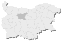
11th Multi-member Constituency – Lovech is a constituency whose borders are the same as Lovech Province in Bulgaria.

The 18th Multi-member Constituency – Razgrad is a constituency whose borders are the same as Razgrad Province in Bulgaria.

The 28th Multi-member Constituency – Targovishte is a constituency whose borders are the same as Targovishte Province in Bulgaria.
Sredogriv is a village in the municipality of Chuprene, in Vidin Province, in northwestern Bulgaria.
Zementsi is a village in the municipality of Krushari, in Dobrich Province, in northeastern Bulgaria.
Benkovski is a village in the Avren Municipality in Varna Province in Northeast Bulgaria. The village is home to over 650 permanent residents, with roughly 40 temporary or seasonal residents. There are 2 grocery shops, and 2 hardware stores. There is a Kinder garden and 2 playgrounds. This small village is named after Georgi Benkovski.
Sibnica is a village situated in Kraljevo municipality in Serbia.
Vitkovac is a village situated in Kraljevo municipality in Serbia.
Pravoševo is a village in the municipality of Prijepolje, Serbia. According to the 2002 census, the village has a population of 85 people.
Portitovtsi is a village in Boychinovtsi Municipality, Montana Province, north-western Bulgaria.

Kozloduy Municipality is a municipality in Vratsa Province, Bulgaria.