
Delicate Arch is a 52-foot-tall (16 m) freestanding natural arch located in Arches National Park, near Moab in Grand County, Utah, United States. The arch is the most widely recognized landmark in Arches National Park and is depicted on Utah license plates and a postage stamp commemorating Utah's centennial anniversary of admission to the Union in 1886. The Olympic torch relay for the 2002 Winter Olympics passed through the arch.

Utah is a landlocked state in the Mountain West subregion of the Western United States. It borders Colorado to its east, Wyoming to its northeast, Idaho to its north, Arizona to its south, and Nevada to its west. Utah also touches a corner of New Mexico in the southeast. In comparison to all the U.S. states and territories, Utah, with a population of just over three million, is the 13th largest by area, the 30th most populous, and the 11th least densely populated. Urban development is mostly concentrated in two regions: the Wasatch Front in the north-central part of the state, which includes the state capital, Salt Lake City, and is home to roughly two-thirds of the population; and Washington County in the southwest, which has somewhat more than 180,000 residents. Most of the western half of Utah lies in the Great Basin.

Bryce Canyon National Park is an American national park located in southwestern Utah. The major feature of the park is Bryce Canyon, which despite its name, is not a canyon, but a collection of giant natural amphitheaters along the eastern side of the Paunsaugunt Plateau. Bryce is distinctive due to geological structures called hoodoos, formed by frost weathering and stream erosion of the river and lake bed sedimentary rock. The red, orange, and white colors of the rocks provide spectacular views for park visitors. Bryce Canyon National Park is much smaller and sits at a much higher elevation than nearby Zion National Park. The rim at Bryce varies from 8,000 to 9,000 feet.

Hawaii is the largest island in the United States, located in the eponymous state of Hawaii. It is the southeasternmost of the Hawaiian Islands, a chain of volcanic islands in the North Pacific Ocean. With an area of 4,028 square miles (10,430 km2), it has 63% of the Hawaiian archipelago's combined landmass. However, it has only 13% of the archipelago's population. The island of Hawaiʻi is the third largest island in Polynesia, behind the north and south islands of New Zealand.

A natural arch, natural bridge, or rock arch is a natural landform where an arch has formed with an opening underneath. Natural arches commonly form where inland cliffs, coastal cliffs, fins or stacks are subject to erosion from the sea, rivers or weathering.
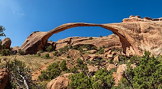
Landscape Arch is a natural arch in Arches National Park, Utah, United States. It is among the longest natural rock arches in the world.
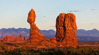
Balanced Rock is one of the most popular features of Arches National Park, situated in Grand County, Utah, United States. Balanced Rock is located next to the park's main road, at about 9.2 miles (14.8 km) from the park entrance. It is one of only a few prominent features clearly visible from the road. The total height of Balanced Rock is 128 feet, with the balancing rock rising 55 feet above the base. This rock is the largest of its kind in the park, weighing approximately 3,577 tons.

The Southwestern United States, also known as the American Southwest or simply the Southwest, is a geographic and cultural region of the United States that includes Arizona and New Mexico, along with adjacent portions of California, Colorado, Nevada, Oklahoma, Texas, and Utah. The largest cities by metropolitan area are Phoenix, Las Vegas, El Paso, Albuquerque, and Tucson. Before 1848, in the historical region of Santa Fe de Nuevo México as well as parts of Alta California and Coahuila y Tejas, settlement was almost non-existent outside of Nuevo México's Pueblos and Spanish or Mexican municipalities. Much of the area had been a part of New Spain and Mexico until the United States acquired the area through the Treaty of Guadalupe Hidalgo in 1848 and the smaller Gadsden Purchase in 1854.

Kodachrome Basin is a state park of Utah, United States. It is situated 5,800 feet (1,767.8 m) above sea level, 12 miles (19 km) south of Utah Route 12, and 20 miles (32 km) southeast of Bryce Canyon National Park. It is accessible from the north from Cannonville by a paved road and from the south by Road 400, a dirt road from the Page, Arizona area to Cannonville, passable for most vehicles in dry conditions. A longer but paved route to Tropic from the south is also available via US-89 and SR-12.

Double Arch is a close-set pair of natural arches in Arches National Park in southern Grand County, Utah, United States, that is one of the better known features of the park.

Interstate 70 (I-70) is a mainline route of the Interstate Highway System in the United States connecting Utah and Maryland. The Utah section runs east–west for approximately 232 miles (373 km) across the central part of the state. Richfield is the largest Utah city served by the freeway, which does not serve or connect any urban areas in the state. The freeway was built as part of a system of highways connecting Los Angeles and the Northeastern United States. I-70 was the second attempt to connect southern California to the east coast of the United States via central Utah, the first being a failed attempt to construct a transcontinental railroad. Parts of that effort were reused in the laying out of the route of I-70.

Devils Garden is an area of Arches National Park, located near Moab, Utah, United States, that features a series of rock fins and arches formed by erosion. The Devils Garden Trail, including more primitive sections and spurs, meanders through the area for 7.2 mi (11.6 km). The trailhead leads directly to Landscape Arch after a 0.8 mi (1.3 km) outbound hike, while Tunnel Arch and Pine Tree Arch can be seen on spur trails on the way to Landscape Arch. Several other arches, including Partition, Navajo, Double O, and Private Arch, as well as the Dark Angel monolith and Fin Canyon, are accessed via the primitive loop trail and its spurs.
The landlocked U.S. state of Utah is known for its natural diversity and is home to features ranging from arid deserts with sand dunes to thriving pine forests in mountain valleys. It is a rugged and geographically diverse state at the convergence of three distinct geological regions: the Rocky Mountains, the Great Basin, and the Colorado Plateau.

Wall Arch was a natural sandstone arch in Arches National Park in southeastern Utah, United States. Before its collapse in 2008, it was ranked 12th in size among the park's over 2,000 arches. At its largest, the opening underneath the span was 71 feet (22 m) wide by 33.5 feet (10 m) high. It consisted of Entrada Sandstone, specifically the member known as Slick Rock. Wall Arch was first reported and named in 1948 by Lewis T. McKinney.
Arches National Park is a national park in eastern Utah, United States. The park is adjacent to the Colorado River, 4 mi (6 km) north of Moab, Utah. The park contains more than 2,000 natural sandstone arches, including the well-known Delicate Arch, which constitute the highest density of natural arches in the world. It also contains a variety of other unique geological resources and formations. The national park lies above an underground evaporite layer or salt bed, which is the main cause of the formation of the arches, spires, balanced rocks, sandstone fins, and eroded monoliths in the area.

The Devils Garden of the Grand Staircase–Escalante National Monument (GSENM) in south central Utah, United States, is a protected area featuring hoodoos, natural arches and other sandstone formations. The area is also known as the Devils Garden Outstanding Natural Area within the National Landscape Conservation System.

Turret Arch is a natural free standing arch in the Windows area of Arches National Park, Utah, United States.

Pine Tree Arch is a large natural sandstone arch located in the Devil's Garden area of Arches National Park near Moab, Utah. The arch measures 149 feet in span.

Dark Angel is a natural sandstone rock formation in Arches National Park, Utah. The formation rises 150 feet above the salt valley and was named after the dark colored sandstone that makes up the pillar.

