Delicate Arch is a 52-foot-tall (16 m) freestanding natural arch located in Arches National Park, near Moab in Grand County, Utah, United States. The arch is the most widely recognized landmark in Arches National Park and is depicted on Utah license plates and a postage stamp commemorating Utah's centennial anniversary of admission to the Union in 1896. The Olympic torch relay for the 2002 Winter Olympics passed through the arch.

A natural arch, natural bridge, or rock arch is a natural landform where an arch has formed with an opening underneath. Natural arches commonly form where inland cliffs, coastal cliffs, fins or stacks are subject to erosion from the sea, rivers or weathering.
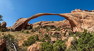
Landscape Arch is a natural arch in Arches National Park, Utah, United States. It is among the longest natural rock arches in the world.
Kolob Arch is a natural arch in Zion National Park, Utah, United States. According to the Natural Arch and Bridge Society (NABS), it is the sixth-longest natural arch in the world. In 2006, the Society measured the span at 287.4 ± 2 feet, which is slightly shorter than Landscape Arch in Arches National Park. Differences in measuring technique or definitions could produce slightly different results and change this ranking.

Natural Bridges National Monument is a U.S. National Monument located about 50 miles (80 km) northwest of the Four Corners boundary of southeast Utah, in the western United States, at the junction of White Canyon and Armstrong Canyon, part of the Colorado River drainage. It features the thirteenth largest natural bridge in the world, carved from the white Permian sandstone of the Cedar Mesa Formation that gives White Canyon its name.
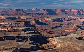
Canyonlands National Park is a national park of the United States located in southeastern Utah near the town of Moab. The park preserves a colorful landscape eroded into numerous canyons, mesas, and buttes by the Colorado River, the Green River, and their respective tributaries. Legislation creating the park was signed into law by President Lyndon B. Johnson on September 12, 1964.

Rainbow Bridge is a natural arch in southern Utah, United States. With a span of 275 feet (84 m), as reported in 1974 by the Bureau of Reclamation, and height of 290 feet (88 m), it is one of the largest natural arches in the world. At the top it is 42 feet (13 m) thick and 33 feet (10 m) wide. The bridge, which is of cultural importance to a number of area Native American tribes, has been designated a Traditional Cultural Property by the National Park Service. Rainbow Bridge National Monument was protected in 1910, and it is administered by Glen Canyon National Recreation Area.

Capitol Reef National Park is a national park of the United States in south-central Utah. The park is approximately 60 miles (100 km) long on its north–south axis and just 6 miles (10 km) wide on average. The park was established in 1971 to preserve 241,904 acres of desert landscape and is open all year, with May through September being the highest visitation months.

Wrather Arch is a cave type natural arch in the Paria Canyon-Vermilion Cliffs Wilderness, in Coconino County, northern Arizona. The sandstone arch is located in the eponymous Wrather Canyon, a short side canyon of Paria Canyon. The Paria River is a tributary of the Colorado River, at its confluence down−canyon at Lee's Ferry. Wrather Arch was first spotted by a local pilot from Page, Arizona, Royce K Knight, as he flew over a remote gorge west of Glen Canyon. Reaching the arch by helicopter in 1963, Knight and National Geographic staff man Walter M Edwards calculated its height as 165 feet and about 250 feet across. A news bulletin from National Geographic dated February 4, 1966 states, "Tall as a 15 story building, Wrather Arch ... The Taj Mahal would fit comfortably into the arch..."

Aloba Arch is a natural arch located in Chad. Large natural arches are somewhat rare outside the southern and western regions of China and the Colorado Plateau of the southwest United States. Chad's Ennedi Plateau, located within the Sahara Desert in the northeast part of the country near Libya and Sudan has a geology similar to the Colorado Plateau and has produced a number of natural arches and similar landforms, although only Aloba can claim to be on the top ten list of longest arches in the world.

Sipapu Bridge is a natural bridge or arch located in the Natural Bridges National Monument in central San Juan County, Utah, United States. The bridge spans White Canyon.

Horseshoe Bend is a horseshoe-shaped incised meander of the Colorado River located near the town of Page, Arizona, United States. It is also referred to as the "east rim of the Grand Canyon."

Devils Garden is an area of Arches National Park, located near Moab, Utah, United States, that features a series of rock fins and arches formed by erosion. The Devils Garden Trail, including more primitive sections and spurs, meanders through the area for 7.2 mi (11.6 km). The trailhead leads directly to Landscape Arch after a 0.8 mi (1.3 km) outbound hike, while Tunnel Arch and Pine Tree Arch can be seen on spur trails on the way to Landscape Arch. Several other arches, including Partition, Navajo, Double O, and Private Arch, as well as the Dark Angel monolith and Fin Canyon, are accessed via the primitive loop trail and its spurs.

Wall Arch was a natural sandstone arch in Arches National Park in southeastern Utah, United States. Before its collapse in 2008, it was ranked 12th in size among the park's over 2,000 arches. At its largest, the opening underneath the span was 71 feet (22 m) wide by 33.5 feet (10 m) high. It consisted of Entrada Sandstone, specifically the member known as Slick Rock. Wall Arch was first reported and named in 1948 by Lewis T. McKinney.
Arches National Park is a national park of the United States in eastern Utah. The park is adjacent to the Colorado River, 4 mi (6 km) north of Moab, Utah. The park contains more than 2,000 natural sandstone arches, including the well-known Delicate Arch, which constitute the highest density of natural arches in the world. It also contains a variety of other unique geological resources and formations. The national park lies above an underground evaporite layer or salt bed, which is the main cause of the formation of the arches, spires, balanced rocks, sandstone fins, and eroded monoliths in the area.

Zion National Park is a national park of the United States located in southwestern Utah near the town of Springdale. Located at the junction of the Colorado Plateau, Great Basin, and Mojave Desert regions, the park has a unique geography and a variety of life zones that allow for unusual plant and animal diversity. Numerous plant species as well as 289 species of birds, 75 mammals, and 32 reptiles inhabit the park's four life zones: desert, riparian, woodland, and coniferous forest. Zion National Park includes mountains, canyons, buttes, mesas, monoliths, rivers, slot canyons, and natural arches. The lowest point in the park is 3,666 ft (1,117 m) at Coalpits Wash and the highest peak is 8,726 ft (2,660 m) at Horse Ranch Mountain. A prominent feature of the 229-square-mile (590 km2) park is Zion Canyon, which is 15 miles (24 km) long and up to 2,640 ft (800 m) deep. The canyon walls are reddish and tan-colored Navajo Sandstone eroded by the North Fork of the Virgin River. The park attracted 5 million visitors in 2023.
Blackwater Natural Bridge is a natural arch in Shoshone National Forest, Wyoming. The arch is located along a ridge at an elevation of 10,777 feet (3,285 m) and is a little over .50 mi (0.80 km) southwest of Coxcomb Mountain. Blackwater Natural Bridge is to the east of the headwaters of Blackwater Creek, which flows north to the North Fork Shoshone River. No official determination of the height or span of the arch has been completed and the estimated size of the arch varies greatly. The non-profit Natural Arch and Bridge Society states that the arch is anywhere from 70 to 100 feet while other sources claim that it may be one of the largest in the world, with a span of 240 ft (73 m), a height of 280 ft (85 m) and with rock thickness of the arch at 32 ft (9.8 m).

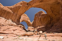
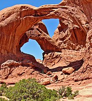
Elephant Butte is a 5,653-foot (1,723 m) summit in Grand County, Utah. It is located within Arches National Park, and is the highest point in the park. Like many of the rock formations in the park, Elephant Butte is composed of Entrada Sandstone. Elephant Butte is a flat-topped cap surrounded by numerous towers and fins including Parade of Elephants. Double Arch is also a natural feature of Elephant Butte and was used as a backdrop for the opening scene of Indiana Jones and the Last Crusade. Precipitation runoff from Elephant Butte drains east into the nearby Colorado River. The first ascent was made September 8, 1953, by Alex Cresswell and Fred Ayres.

Turret Arch is a natural free standing arch in the Windows area of Arches National Park, Utah, United States.