
The Lossos are an ethnic and linguistic group of people living in the Doufelgou District (Préfecture) of the Kara Region in Northern Togo, West Africa. The district capital is Niamtougou which is also an important regional market town. The Lossos live on a plateau in the Togo Mountains between two mountain ranges: the Kabiyé Mountains to the South and the Défalé Chain to the North. They occupy the communities of Niamtougou, Koka, Baga, Ténéga, Siou, Djogrergou, Sioudouga, Kpadeba, Hago, Koukou, and Kounfaga. The Doufelgou District is bordered by the Kozah District to the South, by the Binah District to the East, by the Bassar District to the West, by the Kéran District to the North, and by the international border with Bénin to the Northeast.

Niamtougou is a market town in and district capital of Doufelgou District (Préfecture), in the Kara Region of Togo. It is located 28 km (17 mi) north of Kara on the nation's main north–south road, national road. Niamtougou market is the one of largest in the region and is held every Sunday.

Kara is one of Togo's five regions. Kara is the regional capital.

Rampachodavaram is a census town in East Godavari district of the Indian state of Andhra Pradesh. It is located in Rampachodavaram mandal of Rampachodavaram revenue division. Rampachodavaram is known for its dense jungle and waterfalls which can be accessed by road transport only.

Kara is a city in northern Togo, situated in Kara Region, 413 km north of the capital Lomé. Kara is the capital of the Kara region and, according to the 2010 census, had a population of 94,878. The Kara River flows through the city and is its main resource of water. The city developed from the 1970s onwards from the village originally known as Lama-Kara. Its growth was largely due to the influence of the previous Togolese head of state Gnassingbé Eyadéma who was born in the nearby village of Pya and understood Kara's strategic position at a crossroads of two trade routes.
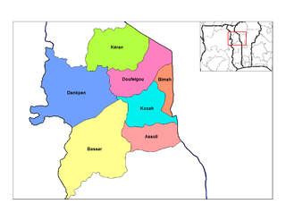
Kéran is a prefecture located in the Kara Region of Togo. The capital city is Kandé. The cantons of Kéran include Kantè, Atalotè, Pessidè, Tamberma-Est (Koutougou), Tamberma-Ouest (Nadoba), Hélota, Warengo, Akponté, Ossacré.
Bassar Prefecture is one of the prefectures of Togo and is located in Kara Region in Togo. The cantons of Bassar include Bassar, Kabou, Bitchabé, Dimouri, Sanda-Kagbanda, Bangéli, Baghan, Sanda-Afowou, Manga, and Kalanga.
The Lambas are an ethnic and linguistic group of people living in the Kéran and Doufelgou Districts (Préfecture) of the Kara Region in Northern Togo and in the Atakora and Donga Departments of Bénin, West Africa. The capital of the Kéran District is Kanté and the capital of the Doufelgou District is Niamtougou.

Boungbale is a town in the Bassar Prefecture in the Kara Region of Togo. Nearby towns and villages include Bongbon, Lidialabo (1.6 km [1.0 mi]), Demon (3.2 km [2.0 mi]), Diabirdo (3.2 km [2.0 mi]), and Tipakpane (3.5 km [2.2 mi]).
Agbande is a village in the Doufelgou Prefecture in the Kara Region of north-eastern Togo.
Tchitchide is a village in the Doufelgou Prefecture in the Kara Region of north-eastern Togo. The village has an elevation of 356 m and is 23 km near with Niamtuu.
Kocia Górka is a village in the administrative district of Gmina Lubanie, within Włocławek County, Kuyavian-Pomeranian Voivodeship, in north-central Poland. Located in the Beskidy Mountains.
Niamtougou International Airport is an airport serving the north of Togo near Niamtougou. It is an international airport and Togo's second largest after Lomé-Tokoin Airport. The airport is located in Baga, 4 km (2.5 mi) north of Niamtougou.

Guzów is a village in the administrative district of Gmina Jasień, within Żary County, Lubusz Voivodeship, in western Poland. It lies approximately 6 kilometres (4 mi) east of Jasień, 15 km (9 mi) north of Żary, and 34 km (21 mi) south-west of Zielona Góra.
Bartniki is a village in the administrative district of Gmina Kiwity, within Lidzbark County, Warmian-Masurian Voivodeship, in northern Poland.

Orenburg Governorate was an administrative division of the Russian Empire with the center in the city of Orenburg.
Nawdm is a Gur language of Togo and Ghana. There are about 8000 of the speakers in Ghana and 200 000 speakers in Togo.
Bimah or Binah is a prefecture located in the Kara Region of Togo. The prefecture seat is located in Pagouda.

Khanuy-Gol is a volcanic field in Mongolia. Khanuy-Gol is located in the northern Hangai range, north of the settlement of Bulgan.

Dows Creek is a locality in the Mackay Region, Queensland, Australia.
