
The Royal Borough of Kensington and Chelsea is an Inner London borough with royal status. It is the smallest borough in London and the second smallest district in England; it is one of the most densely populated administrative regions in the United Kingdom. It includes affluent areas such as Notting Hill, Kensington, South Kensington, Chelsea, and Knightsbridge.

Fulham is an area of the London Borough of Hammersmith & Fulham in West London, England, 3.6 miles (5.8 km) southwest of Charing Cross. It lies on the north bank of the River Thames, bordering Hammersmith, Kensington and Chelsea. The area faces Wandsworth, Putney, Barn Elms and the London Wetland Centre in Barnes. on the far side of the river.
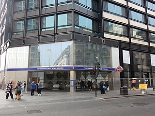
Tottenham Court Road is a London Underground and Elizabeth line station in St Giles in the West End of London. The station is served by the Central line, the Elizabeth line and the Charing Cross branch of the Northern line. The station is located at St Giles Circus, the junction of Tottenham Court Road, Oxford Street, New Oxford Street and Charing Cross Road and is in Travelcard Zone 1, with a second entrance at Dean Street.

Crossrail is a completed railway project centred around London. It provides a high-frequency hybrid commuter rail and rapid transit system, known as the Elizabeth line, that crosses the capital from suburbs on the west to east and connects two major railway lines terminating in London: the Great Western Main Line and the Great Eastern Main Line. The project was approved in 2007, and construction began in 2009 on the central section and connections to existing lines that became part of the route, which has been named the Elizabeth line in honour of Queen Elizabeth II who opened the line on 17 May 2022 during her Platinum Jubilee. The central section of the line between Paddington and Abbey Wood opened on 24 May 2022, with 12 trains per hour running in each direction through the core section in Central London.

Chelsea is an affluent area in West London, England, due south-west of Charing Cross by approximately 2.5 miles. It lies on the north bank of the River Thames and for postal purposes is part of the south-western postal area.

The Metropolitan Borough of Chelsea was a metropolitan borough of the County of London between 1900 and 1965. It was created by the London Government Act 1899 from most of the ancient parish of Chelsea. Following the London Government Act 1963, it was amalgamated with the Royal Borough of Kensington in 1965 to form the Royal Borough of Kensington and Chelsea.
King's Road or Kings Road is a major street stretching through Chelsea and Fulham, both in west London, England. It is associated with 1960s style and with fashion figures such as Mary Quant and Vivienne Westwood. Sir Oswald Mosley's Blackshirt movement had a barracks on the street in the 1930s.

Ladbroke Grove is an area and a road in North Kensington in the Royal Borough of Kensington and Chelsea, passing through Kensal Green and Notting Hill, running north–south between Harrow Road and Holland Park Avenue.
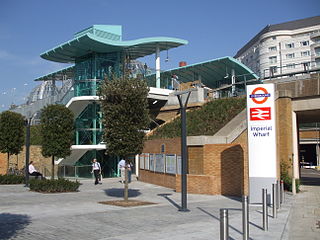
Imperial Wharf is a station located in Sands End in West London for London Overground and National Rail services.
Abbey Wood is an area in southeast London, England, straddling the border between the Royal Borough of Greenwich and the London Borough of Bexley. It is located 10.6 miles (17 km) east of Charing Cross. According to the 2021 census, Abbey Wood has a population of 17,700.

North Kensington is an area of west London. It is north of Notting Hill and south of Kensal Green and in the Royal Borough of Kensington and Chelsea. The names North Kensington and Ladbroke Grove describe the same area.

Crossrail 2 is a suspended proposal for a hybrid commuter rail and rapid transit route in South East England, running from nine stations in Surrey to three in Hertfordshire, providing a new North–South rail link across Greater London. It would connect the South West Main Line to the West Anglia Main Line, via Victoria and King's Cross St Pancras. The intent was to alleviate severe overcrowding that would otherwise occur on commuter rail routes into Central London. When first proposed, the hope was for construction to start around 2023, with the new line opening from the early 2030s. The project's cost has been estimated at £31.2 billion.

Charterhouse Square is a garden square, a pentagonal space, in Farringdon, in the London Borough of Islington, and close to the former Smithfield Meat Market. The square is the largest courtyard or yard associated with the London Charterhouse, mostly formed of Tudor and Stuart architecture restored after the London Blitz. The square adjoins other buildings including a small school. It lies between Charterhouse Street, Carthusian Street and the main Charterhouse complex of buildings south of Clerkenwell Road. The complex includes a Chapel, Tudor Great Hall, Great Chamber, the Barts and The London School of Medicine and Dentistry and a 40-resident almshouse.

Queen Charlotte's and Chelsea Hospital is one of the oldest maternity hospitals in Europe, founded in 1739 in London. Until October 2000, it occupied a site at 339–351 Goldhawk Road, Hammersmith, but is now located between East Acton and White City, adjacent to the Hammersmith Hospital. It is managed by the Imperial College Healthcare NHS Trust.

Walham Green is the historic name of an English village, now part of inner London, in the parish of Fulham in the County of Middlesex. It was located between the hamlet of North End to the north, and Parsons Green to the south. To the east it was bounded by Counter's Creek, the historical boundary with the parish of Chelsea, and to the south-east is Sands End.

King's Road Chelsea railway station is a proposed station on Crossrail 2, a planned underground railway line through London in the United Kingdom. If constructed, the station would serve the King's Road area of Chelsea.
Ladbroke Grove is a proposed railway station in London, England on the Crossrail Route between Old Oak Common and Paddington. This is not part of the internal route and would be added at a later stage. Locals want the station to be called Portobello Central to serve the nearby Portobello Market. It was originally called Kensal.

Chelsea Fire Station is located at 264 King's Road, London.
Auriens is a retirement complex in Chelsea, London, in Dovehouse Street, overlooking Dovehouse Green and the King's Road.

Cale Street is a street in Chelsea, London. It runs between Dovehouse Street in the west and the junction of Elystan Street and Elystan Place in the east. It originally formed the southern boundary of Chelsea Common. The street was laid out in 1836, and was called Bond Street at the western end and College Place at the eastern but was later renamed Cale Street in honour of Judith Cale, a benefactor to the parish.


