Cale Street

Last updated

Cale Street
London Chelsea Cale Street geograph-3064292-by-Ben-Brooksbank.jpg
Cale Street from Dovehouse Street, 1955
Kensington and Chelsea London UK location map.svg
Red pog.svg
Former name(s)Bond Street (west) College Place (east)
AreaChelsea
Location Royal Borough of Kensington and Chelsea, London, UK
Coordinates 51°29′25″N0°10′08″W / 51.4904°N 0.1690°W / 51.4904; -0.1690
Construction
CompletionBy 1836
Other
Known forLocation of distillery where Beefeater Gin first made

Cale Street is a street in Chelsea, London. It runs between Dovehouse Street in the west and the junction of Elystan Street and Elystan Place in the east. It originally formed the southern boundary of Chelsea Common. The street was laid out in 1836, and was called Bond Street at the western end and College Place at the eastern but was later renamed Cale Street in honour of Judith Cale, a benefactor to the parish.

Contents

Location

Cale Street is in the Chelsea district of London's Royal Borough of Kensington and Chelsea in England. It runs between Dovehouse Street (formerly Arthur Street) in the west and the junction of Elystan Street and Elystan Place in the east and is joined on its north side by Guthrie Street, Stewart's Grove, Bury Walk, Ixworth Place, and Whitehead's Grove. It is crossed by Sydney Street (formerly Robert Terrace) and joined on its south side by St Luke's Street, Astell Street, Danube Street, Godfrey Street, and Jubilee Place. [1] [2] Crooked Usage once joined Cale Street to Britten Street in the south. [2]

History

Cale Street on an 1869-1880 Ordnance Survey map Cale Street on Sheet 053, Ordnance Survey, 1869-1880.png
Cale Street on an 1869–1880 Ordnance Survey map
Beefeater Gin, first distilled in Cale Street Beefeater Gin.jpg
Beefeater Gin, first distilled in Cale Street

Cale Street originally formed the southern boundary of the 37-acre (15 ha) Chelsea Common, with a pond and gravel pits, but over time the land was all developed for housing. [3] A new street was laid out in 1836, and was called Bond Street at the western end and College Place at the eastern. [3] The street was later renamed Cale Street in honour of Judith Cale, who died in 1717 and left a legacy for the benefit of six poor widows of Chelsea, the interest on which was distributed to them each Christmas Day. [4] [5]

In 1820, the Chelsea Distillery, a gin manufacturer in what became Cale Street, was opened by the Taylor family, and in 1863, was purchased for £400 by James Burrough, a pharmacist and the founder of Beefeater Gin, which was first produced there, and distilled there until 1908, when it moved to the Cale Street Distillery in Hutton Road in Lambeth. [6] [7] [8]

The Japanese watercolour artist and writer Yoshio Markino painted Gale Street, Chelsea, in Snow in 1907, and this is thought to be a misrendering of Cale Street, which he would have seen from a window of his then lodgings in Sydney Street. [9]

Buildings

Two blocks of Sutton Dwellings between Cale Street and Ixworth Place, 2009 William Sutton Estate - geograph.org.uk - 1181894.jpg
Two blocks of Sutton Dwellings between Cale Street and Ixworth Place, 2009

St Wilfred's Convent once stood in gardens on the north side at the western end, opposite where the Royal Brompton Hospital is now on the south side. [10]

Also on the south side is St Luke's Church and gardens on the site of the former burial ground for Chelsea Old Church which is located further south near the Chelsea Embankment. The burial ground was consecrated in 1812 and had a 9-foot-high (2.7 m) wall and railings to protect against grave robbers. [11] St Luke's was built between 1820 and 1824, over the vaults used by Chelsea Old Church, when the old church was felt to be too small for the population of the area. [12] Its grounds were used for burials until 1857 [11] before in 1881 they were converted to gardens. A new boundary for the church and part of the gardens was created using the gravestones from the burial ground. Today, the area to the north of the church adjacent to Cale Street is a recreation ground while the area to the south of the church adjacent to Britten Street is formal gardens. [12]

Sutton Dwellings, an estate of housing association properties built in 1913 [13] is on the north side of Cale Street, and was threatened with redevelopment, until the local council declared it a Conservation Area. [14]

In the 1960s the fashion boutique Hung On You was at No. 22, run by the designer Michael Rainey [15] and whose customers included the Beatles. The shop moved to Chelsea's King's Road in 1967. [4]

Tom's Kitchen was a restaurant at No. 27 run by Tom Aikens from November 2006 [16] to January 2020. [17]

Related Research Articles

<span class="mw-page-title-main">Cheam</span> London suburb

Cheam is a suburb of London, England, 10.9 miles (17.5 km) southwest of Charing Cross. It is divided into North Cheam, Cheam Village and South Cheam. Cheam Village contains the listed buildings Lumley Chapel and the 16th-century Whitehall. It is adjacent to two large parks, Nonsuch Park and Cheam Park. Nonsuch Park contains the listed Nonsuch Mansion. Parts of Cheam Park and Cheam Village are in a conservation area. Cheam is bordered by Worcester Park to the northwest, Morden to the northeast, Sutton to the east, Epsom, Ewell and Stoneleigh to the west and Banstead and Belmont to the south.

<span class="mw-page-title-main">Royal Borough of Kensington and Chelsea</span> Place in United Kingdom

The Royal Borough of Kensington and Chelsea is an Inner London borough with royal status. It is the smallest borough in London and the second smallest district in England; it is one of the most densely populated administrative regions in the United Kingdom. It includes affluent areas such as Notting Hill, Kensington, South Kensington, Chelsea, and Knightsbridge.

<span class="mw-page-title-main">Pimlico</span> Human settlement in England

Pimlico is an area of Central London in the City of Westminster, built as a southern extension to neighbouring Belgravia. It is known for its garden squares and distinctive Regency architecture. Pimlico is demarcated to the north by Victoria Station, by the River Thames to the south, Vauxhall Bridge Road to the east and the former Grosvenor Canal to the west. At its heart is a grid of residential streets laid down by the planner Thomas Cubitt, beginning in 1825 and now protected as the Pimlico Conservation Area. The most prestigious are those on garden squares, with buildings decreasing in grandeur away from St George's Square, Warwick Square, Eccleston Square and the main thoroughfares of Belgrave Road and St. George's Drive. Additions have included the pre–World War II Dolphin Square and the Churchill Gardens and Lillington and Longmoore Gardens estates, now conservation areas in their own right. The area has over 350 Grade II listed buildings and several Grade II* listed churches. At the western edge of Pimlico, on the borders of Chelsea, Pimlico Road has become known in recent years for its interiors and design stores.

<span class="mw-page-title-main">West Norwood</span> Suburb of London

West Norwood is a largely residential area of south London within the London Borough of Lambeth, located 5.4 miles (8.7 km) south south-east of Charing Cross. The centre of West Norwood sits in a bowl surrounded by hillsides on its east, west and south sides. From many parts of the area, distant views can be seen, of places such as the City of London, Canary Wharf and Crystal Palace.

<span class="mw-page-title-main">Brookwood Cemetery</span> Burial ground in Surrey, England

Brookwood Cemetery, also known as the London Necropolis, is a burial ground in Brookwood, Surrey, England. It is the largest cemetery in the United Kingdom and one of the largest in Europe. The cemetery is listed a Grade I site in the Register of Historic Parks and Gardens.

<span class="mw-page-title-main">Chelsea, London</span> District in west London, England

Chelsea is an affluent area in West London, England, due south-west of Charing Cross by approximately 2.5 miles. It lies on the north bank of the River Thames and for postal purposes is part of the south-western postal area.

<span class="mw-page-title-main">Wincanton</span> Human settlement in England

Wincanton is a town and electoral ward in South Somerset, southwest England. The town lies off the A303 road, a main route between London and South West England, and has some light industry. In the 2021 census the civil parish had a population of 6,568.

<span class="mw-page-title-main">Beefeater Gin</span> Brand of gin

Beefeater Gin is a brand of gin owned by Pernod Ricard and bottled and distributed in the United Kingdom. Beefeater remained in the control of its founding Burrough family until 1987. The Beefeater distillery is one of 24 in London.

<span class="mw-page-title-main">Old Church Street</span> Street in London, England

Old Church Street is a street in London, England in the Royal Borough of Kensington and Chelsea.

<span class="mw-page-title-main">Yoshio Markino</span>

Yoshio Markino was a Japanese artist and author who from 1897 – 1942 was based in London.

<span class="mw-page-title-main">St Marylebone Parish Church</span> Church in London, England

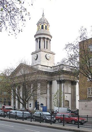
St Marylebone Parish Church is an Anglican church on the Marylebone Road in London. It was built to the designs of Thomas Hardwick in 1813–17. The present site is the third used by the parish for its church. The first was further south, near Oxford Street. The church there was demolished in 1400 and a new one erected further north. This was completely rebuilt in 1740–42, and converted into a chapel-of-ease when Hardwick's church was constructed. The Marylebone area takes its name from the church. Located behind the church is St Marylebone School, a Church of England school for girls.

<span class="mw-page-title-main">St Olave's Church, Silver Street</span> Church in London, England

St Olave's Church, Silver Street was a church on the south side of Silver Street, off Wood Street in the Aldersgate ward of the City of London. It was dedicated to St Olaf, a Norwegian Christian ally of the English king Ethelred II. The church was destroyed by the Great Fire of London in 1666 and not rebuilt.

<span class="mw-page-title-main">St Katherine Coleman</span> Former church-site in London

St Katherine Coleman was a parish church in the City of London, situated in St Katherine's Row, on the south side of Fenchurch Street, in Aldgate Ward. Of medieval origin, it narrowly escaped destruction in the Great Fire of London in 1666, but was rebuilt in the eighteenth century. The church closed in November 1926 and was demolished soon afterwards.

<span class="mw-page-title-main">St Luke's Church, West Norwood</span> Church

St Luke's Church in West Norwood is an Anglican church that worships in a Grade II* listed building. It stands on a prominent triangular site at the south end of Norwood Road, where the highway forks to become Knights Hill and Norwood High Street.

<span class="mw-page-title-main">King's Road Chelsea railway station</span> Proposed Crossrail 2 stop

King's Road Chelsea railway station is a proposed station on Crossrail 2, a planned underground railway line through London in the United Kingdom. If constructed, the station would serve the King's Road area of Chelsea.
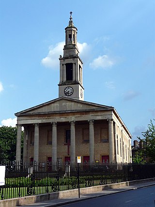
<span class="mw-page-title-main">Sutton Dwellings</span> Residential buildings in London, England

Sutton Dwellings, also known as the Sutton Estate, are a series of 14 residential buildings in Chelsea, London, U.K.

<span class="mw-page-title-main">Dovehouse Street</span> Street in London, England

Dovehouse Street is a street in Chelsea, London. It runs roughly north to south from Fulham Road to King's Road, having junctions with Cale Street and Britten Street, among others.

Philip Howard is a South African-British chef, chef patron, and restaurateur. He gained cooking skills while working under Marco Pierre White at Harveys and Simon Hopkinson at Bibendum. Howard and White's then-business partner Nigel Platts-Martin opened London restaurant The Square in December 1991, despite both of their inexperience in operating a restaurant at the time.

<span class="mw-page-title-main">Elystan Street</span> Restaurant in London, England

Elystan Street is a London restaurant co-owned by chef patron Phil Howard and Rebecca Mascarenhas. Howard and Mascarenhas established the restaurant on 27 September 2016, six months after Howard sold and left his previous restaurant The Square. Elystan Street earned its first Michelin star in October 2017 and has retained it since.

<span class="mw-page-title-main">Chelsea Square</span> Garden square in London, England

Chelsea Square is a garden square in Chelsea, London.

References

  1. Greater London Street Atlas. Geographia, London, August 1986 edition. Map page 3. ISBN   0092027903
  2. 1 2 3 Sheet 53, Ordnance Survey, 1869–1880.
  3. 1 2 "Settlement and building: From 1680 to 1865, Chelsea Park to Blacklands". British History Online. Retrieved 9 June 2020.
  4. 1 2 "Cale Street" in Christopher Hibbert; Ben Weinreb; John Keay; Julia Keay (2008). The London Encyclopaedia (3rd ed.). London: Macmillan. p. 120. ISBN   978-0-230-73878-2.
  5. Reports from the Commissioners &c. Vol. XII. 1826. p. 196.
  6. "Our History". Beefeater Gin. Archived from the original on 26 September 2020. Retrieved 10 June 2020. Retrieved 9 June 2020.
  7. "Great drinks of Europe: Beefeater gin", The New European, 4 October 2017. Retrieved 9 June 2020.
  8. Stephenson, Tristan (2016). The Curious Bartender's Gin Palace. London: Ryland Peters & Small. p. 204. ISBN   978-1-84975-701-0.
  9. Rodner, William S. (2012). Edwardian London through Japanese Eyes: The Art and Writings of Yoshio Markino, 1897–1915. Leiden: BRILL. p. 45. ISBN   978-90-04-24946-2.
  10. OpenStreetMap. Retrieved 8 June 2020.
  11. 1 2 History of St Luke's Gardens. Royal Borough of Kensington and Chelsea. Retrieved 11 June 2020.
  12. 1 2 Historic England. "St Luke's Garden (1000834)". National Heritage List for England . Retrieved 12 June 2020.
  13. The Sutton Dwellings, Chelsea, London SW7. George P. Landow, Victorian Web, 22 January 2011. Retrieved 10 June 2020.
  14. Save The Historic Sutton Estate, Retrieved 9 June 2020.
  15. Lunch With ... Michael Rainey. The Tapas Lunch Co. Retrieved 9 June 2020.
  16. "Matthew Norman reviews Tom's Kitchen, Cale Street, London SW3". The Guardian. 18 November 2006. Retrieved 9 June 2020. (subscription required)
  17. McAllister, James (22 January 2020). "Tom Aikens closes final Tom's Kitchen site". bighospitality.co.uk. Retrieved 8 June 2020.