
Greenford is a suburb in the London Borough of Ealing in Greater London, England, lying 11 miles (18 km) west from Charing Cross in Central London. It was an ancient parish in the historic county of Middlesex. It has a population of 46,787 inhabitants, or 62,126 with the inclusion of Perivale.
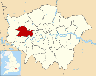
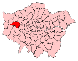
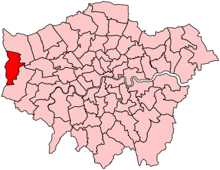
The London Borough of Ealing is a London borough in West London. It comprises seven major towns: Acton (W3), Ealing, Greenford (UB6), Hanwell (W7), Northolt (UB5), Perivale (UB6) and Southall.
Northolt is an area in the London Borough of Ealing, London, England, and is 11 miles (17.7 km) west-northwest of Charing Cross.

South Norwood Country Park is a park in South Norwood, close to Elmers End and Birkbeck train stations. The historic Kent-Surrey border runs through the site, and since 1965 it has been located wholly in the London Borough of Croydon. It is a 47 hectare green space which opened in 1989. The park is a mix of countryside and parkland, and land formerly used for sewage farms serving the growing London population.

Berryhill Fields is an area of grassland in the heart of Stoke-on-Trent in England, between the housing estates of Bentilee and Berryhill and the town of Fenton. It is a local nature reserve, owned and managed by Stoke-on-Trent City Council. Its area is 63.31 hectares.
Archdeacon Newton is a hamlet and rural parish of several farms in the borough of Darlington and the ceremonial county of County Durham, in England. The population taken at the 2011 Census was less than 100. Details are maintained in the parish of Walworth. It is associated with an abandoned village site under pasture and farm buildings, and situated a short distance to the north-west of Darlington. The lost settlement was in existence by the early 15th century, and remained inhabited at least until the 1890s. There was a moated manor house at the southern end, part of which remains as the Old Hall, now a barn. At the north end of the site was the chapel, and in the middle were tofts and enclosures, with a ridge and furrow field and a trackway leading to the south-east. The site of the abandoned village is now a scheduled monument and the Old Hall is a listed building.
Ealing North is a constituency, created in 1950. Since the 2019 general election, it has been represented in the House of Commons of the UK Parliament by James Murray of the Labour Co-operative party.
Uxbridge was a seat returning one Member of Parliament (MP) of the House of Commons of the UK Parliament from 1885 to 2010. Its MPs elected were: Conservative Party candidates for 107 years and Labour Party candidates for 18 years. The closing 40 years of the seat's history saw Conservative victory — in 1997 on a very marginal majority in relative terms.

Wyberton is a village in Lincolnshire, England. It lies just south-west of Boston, and on the B1397 – the former A16 London Road – between Boston and Kirton. The A16 along the former East Lincolnshire railway line bisects the village. The population of the civil parish at the 2011 census was 3,747.
Ealing was a local government district from 1863 to 1965 around the town of Ealing which formed part of the built up area of London until 1965, where it became part of Greater London.
Barrs Court is an urban residential area in the unitary authority of South Gloucestershire to the East of the City & County of Bristol, England,

Gunnersbury Park is a park in the London Borough of Hounslow between Acton, Brentford, Chiswick and Ealing, West London, England. Purchased for the nation from the Rothschild family, it was opened to the public by Neville Chamberlain, then Minister of Health, on 21 May 1926. The park is currently jointly managed by Hounslow and Ealing borough councils. A major restoration project funded by the Heritage Lottery Fund was completed in 2018. The park and garden is Grade II listed.
Headstone Manor is a 14th century Grade I listed moated manor house in Harrow, England, and today a part of the Headstone Manor and Museum. Headstone Manor & Museum is a museum of the site itself as well as Harrow more generally. It also hosts a programme of talks, tours, events and family activities for visitors. Headstone Manor & Museum is open Tuesday to Sunday, all year round. Entry to the site and the museum is free.

The Harrow Museum, known as the Headstone Manor & Museum, is the local history museum for the London Borough of Harrow in northwest London, England.

Great Ealing School was situated on St Mary's Road, Ealing W5 London and was founded in 1698. In its heyday of the 19th century, it was as famous as Eton or Harrow, being considered "the best private school in England".

Northala Fields is a park located in Northolt, Greater London. It was opened in 2008 and consists of four artificial hills standing next to the A40 Western Avenue, as well as several fishing lakes, a large field area a children's play area and adjacent café. The hills were constructed using rubble from the demolition of the original Wembley Stadium, which was closed in 2000 and demolished in 2003. The park was created as part of the Northolt and Greenford Country Park project, and backs onto the older Rectory Park.

Manor Farm is a 22-acre (8.9 ha) historic site in Ruislip, Greater London. It incorporates a medieval farm complex, with a main old barn dating from the 13th century and a farm house from the 16th. Nearby are the remains of a motte-and-bailey castle believed to date from shortly after the Norman conquest of England. Original groundwork on the site has been dated to the 9th century.

Harmondsworth Great Barn is a medieval barn on the former Manor Farm in the village of Harmondsworth, in the London Borough of Hillingdon, England in the historic county of Middlesex). It is north-west of fields and the A4 next to Heathrow Airport. Built in the early 15th century by Winchester College, it is the largest timber-framed building in England and is regarded as an outstanding example of medieval carpentry. It was described by the English poet John Betjeman as the "Cathedral of Middlesex". A similar though smaller barn is part of the Manor Farm complex in Ruislip.

Northolt Manor is a 1.8 hectare Scheduled Ancient Monument, Local Nature Reserve and Site of Borough Importance for Nature Conservation, Grade II, in Northolt in the London Borough of Ealing. It is owned and managed by Ealing Council.
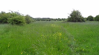
Islip Manor Meadows is a 23.75 hectare Local Nature Reserve and Site of Metropolitan Importance for Nature Conservation in Northolt in the London Borough of Ealing. It is owned and managed by Ealing Council.
