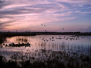
Strumpshaw Fen is a nature reserve managed by the Royal Society for the Protection of Birds (RSPB). It is situated at Strumpshaw on the River Yare in the English county of Norfolk around 6 miles (9.7 km) east of Norwich. The Buckenham Marshes RSPB reserve borders the reserve to the east.

Ouse Washes is a linear 2,513.6-hectare (6,211-acre) biological Site of Special Scientific Interest stretching from near St Ives in Cambridgeshire to Downham Market in Norfolk. It is also a Ramsar internationally important wetland site, a Special Protection Area for birds, a Special Area of Conservation and a Nature Conservation Review site, Grade I. An area of 186 hectares between March and Ely is managed by the Wildlife Trust for Bedfordshire, Cambridgeshire and Northamptonshire and another area near Chatteris is managed by the Royal Society for the Protection of Birds. The Wildfowl & Wetlands Trust manages another area near Welney.

The Cotswold Water Park is the United Kingdom's largest marl lake system, straddling the Wiltshire–Gloucestershire border, north-west of Cricklade and south of Cirencester. There are 180 lakes, spread over 42 square miles (110 km2).

Loynton Moss is a nature reserve of the Staffordshire Wildlife Trust, near the village of Woodseaves, in Staffordshire, England. It is adjacent to the Shropshire Union Canal, as it runs from nearby Norbury to High Offley.

RSPB Dearne Valley Old Moor is an 89-hectare (220-acre) wetlands nature reserve in the Dearne Valley near Barnsley, South Yorkshire, run by the Royal Society for the Protection of Birds (RSPB). It lies on the junction of the A633 and A6195 roads and is bordered by the Trans Pennine Trail long-distance path. Following the end of coal mining locally, the Dearne Valley had become a derelict post-industrial area, and the removal of soil to cover an adjacent polluted site enabled the creation of the wetlands at Old Moor.

Coombe Hill Canal lies in the Vale of Gloucester, south west England, north of Leigh and runs west 2.75 miles (4.43 km) from Coombe Hill Basin to the River Severn near Wainlode Hill. It opened in 1796 and closed 80 years later in 1876, after the only lock was damaged by flooding. The Gloucestershire Wildlife Trust purchased the Coombe Hill Canal nature reserve in 1985 and the area is managed by the trust. Adjacent to the Coombe Hill Canal is a large area of wet meadowland situated midway between Gloucester and Tewkesbury to the west of the A38, which was purchased by the trust in 1999. There is a north and a south meadow. This land and the canal itself often flood in winter, which attracts hundreds of wildfowl.

Lawrence Weston is a post-war housing estate in northwest Bristol, England, between Henbury and Shirehampton. The estate is bounded in the east by the Blaise Castle estate and woods. It is at the edge of the Severn flood plain, directly beneath the wooded Kingsweston Hill. The industrial complex and port of Avonmouth is a mile or so west, across the flood plain. Lawrence Weston forms part of the electoral ward of Avonmouth and Lawrence Weston.

Brandon Marsh is a Site of Special Scientific Interest (SSSI) and nature reserve in Warwickshire, England. It is situated adjacent to the River Avon, near the village of Brandon, a few miles east of Coventry.

Burham Marsh nature reserve is an 11 hectare tidal Reed bed on the River Medway 5 miles northwest of Maidstone. It is just east of Snodland but being on the east bank of the river it is accessed via Burham. It is part the Holborough to Wouldham Marshes Site of Special Scientific Interest.

Ashleworth Ham is a 104.73-hectare (258.8-acre) biological Site of Special Scientific Interest. It is a large area of grassland on the Severn floodplain, north of Ashleworth in Gloucestershire, England. It is registered as a Site of Special Scientific Interest and was notified in 1974 and renotified in 1985. Ashleworth Ham received this designation because it is one of three sites in the Severn Vale where migratory waterfowl winter.

Croxall Lakes is a nature reserve located between the villages of Croxall and Alrewas, Staffordshire, in the United Kingdom. The nature reserve comprises two lakes and grassland between them. The lakes were formed through the quarrying of sand and gravel deposits, these excavations subsequently flooded and were then restored to create the nature reserve. The site is managed by Staffordshire Wildlife Trust and owned by the National Forest Company. The reserve is an important stop off point for a wide variety of migrating birds due to its location at the meeting point of three rivers, the Trent, Tame and Mease.
The San Luis National Wildlife Refuge Complex is located in the northern San Joaquin Valley, within Merced County and Stanislaus County of California. The complex, with four federal National Wildlife Refuges, is managed by the U.S Fish & Wildlife Service.
Gwent Wildlife Trust (GWT) is a wildlife trust covering the area between the lower Wye and Rhymney rivers which forms the vice county of Monmouthshire in south-east Wales. It is a registered charity and a member of the Wildlife Trusts Partnership.

Sweetbriar Road Meadows is a 9.7-hectare (24-acre) biological Site of Special Scientific Interest in Norwich in Norfolk.
Gosforth Nature Reserve is a wildlife haven in Tyne and Wear, England. It includes extensive woodland and wetland habitats and is managed by the Natural History Society of Northumbria. Access to the reserve is restricted to NHSN members and those in possession of a valid day pass. Dog walking and other recreational activities are not permitted on site. The reserve is part of Gosforth Park, the old estate of Gosforth House.
Chaceley Meadow is a 1.8-hectare (4.4-acre) biological Site of Special Scientific Interest in Gloucestershire, notified in 1954 and renotified in 1993. It lies on the eastern edge of Chaceley village and is about half a mile west of the River Severn.

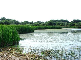
Magor Marsh is a 36-hectare (90-acre) wetland reserve, located on the Welsh side of the Severn Estuary. It is managed by the Gwent Wildlife Trust. It has a great variety of habitats, including damp hay meadows, sedge fen, reed bed, scrub and wet woodland. There are also numerous reens and a large pond.

Long Herdon Meadow is a 4.5-hectare (11-acre) biological Site of Special Scientific Interest south of Marsh Gibbon in Buckinghamshire. It is part of Upper Ray Meadows nature reserve, which is managed by the Berkshire, Buckinghamshire and Oxfordshire Wildlife Trust.
Astonfields Balancing Lakes is a local nature reserve on the north-eastern edge of Stafford, in Staffordshire, England.
Dunsdon National Nature Reserve is a nature reserve of the Devon Wildlife Trust, near Dunsdon and about 3.5 miles (5.6 km) north-west of Holsworthy, in Devon, England. The habitat is culm grassland.


